

Pacific Trade Winds Biome
379
search for studies pertaining to ARCH suggests that some regional investigators have not
clearly differentiated shelf and deep-water conditions.
So, for those reasons, the ARCH province as used here comprises the deep basins of
the South China Sea, of the centrally grouped Sulu, Celebes, Molucca, Flores, and Banda
Seas, and, further to the east within the arcs of the Bismarck, Solomon, and Vanuatu
Islands, of the Bismarck, Solomon, and Coral Seas. The last of these is by far the largest
and could easily be considered separately as a unique province: it is bounded from the
Pacific by the Solomon and New Hebrides and from the Tasman by the eastward passage
across the north of that sea of the retroflected East Australian Current (see TASM). It
therefore has a very large latitudinal extent, from about 22
N, south of Taiwan, to about
32–35
S just beyond Norfolk Island, a convenient marker for the southern border of the
Coral Sea being the chlorophyll enhancement associated with the reflected flow.
Continental Shelf Topography and Tidal and Shelf-Edge Fronts
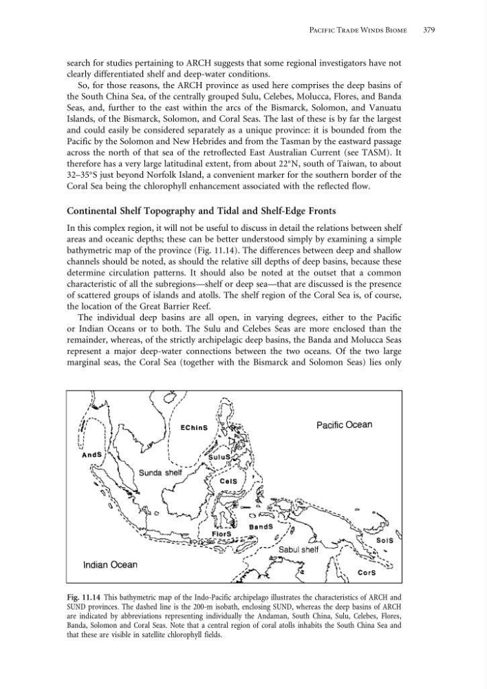
In this complex region, it will not be useful to discuss in detail the relations between shelf
areas and oceanic depths; these can be better understood simply by examining a simple
bathymetric map of the province (Fig. 11.14). The differences between deep and shallow
channels should be noted, as should the relative sill depths of deep basins, because these
determine circulation patterns. It should also be noted at the outset that a common
characteristic of all the subregions—shelf or deep sea—that are discussed is the presence
of scattered groups of islands and atolls. The shelf region of the Coral Sea is, of course,
the location of the Great Barrier Reef.
The individual deep basins are all open, in varying degrees, either to the Pacific
or Indian Oceans or to both. The Sulu and Celebes Seas are more enclosed than the
remainder, whereas, of the strictly archipelagic deep basins, the Banda and Molucca Seas
represent a major deep-water connections between the two oceans. Of the two large
marginal seas, the Coral Sea (together with the Bismarck and Solomon Seas) lies only
Fig. 11.14 This bathymetric map of the Indo-Pacific archipelago illustrates the characteristics of ARCH and
SUND provinces. The dashed line is the 200-m isobath, enclosing SUND, whereas the deep basins of ARCH
are indicated by abbreviations representing individually the Andaman, South China, Sulu, Celebes, Flores,
Banda, Solomon and Coral Seas. Note that a central region of coral atolls inhabits the South China Sea and
that these are visible in satellite chlorophyll fields.
379
search for studies pertaining to ARCH suggests that some regional investigators have not
clearly differentiated shelf and deep-water conditions.
So, for those reasons, the ARCH province as used here comprises the deep basins of
the South China Sea, of the centrally grouped Sulu, Celebes, Molucca, Flores, and Banda
Seas, and, further to the east within the arcs of the Bismarck, Solomon, and Vanuatu
Islands, of the Bismarck, Solomon, and Coral Seas. The last of these is by far the largest
and could easily be considered separately as a unique province: it is bounded from the
Pacific by the Solomon and New Hebrides and from the Tasman by the eastward passage
across the north of that sea of the retroflected East Australian Current (see TASM). It
therefore has a very large latitudinal extent, from about 22
N, south of Taiwan, to about
32–35
S just beyond Norfolk Island, a convenient marker for the southern border of the
Coral Sea being the chlorophyll enhancement associated with the reflected flow.
Continental Shelf Topography and Tidal and Shelf-Edge Fronts
In this complex region, it will not be useful to discuss in detail the relations between shelf
areas and oceanic depths; these can be better understood simply by examining a simple
bathymetric map of the province (Fig. 11.14). The differences between deep and shallow
channels should be noted, as should the relative sill depths of deep basins, because these
determine circulation patterns. It should also be noted at the outset that a common
characteristic of all the subregions—shelf or deep sea—that are discussed is the presence
of scattered groups of islands and atolls. The shelf region of the Coral Sea is, of course,
the location of the Great Barrier Reef.
The individual deep basins are all open, in varying degrees, either to the Pacific
or Indian Oceans or to both. The Sulu and Celebes Seas are more enclosed than the
remainder, whereas, of the strictly archipelagic deep basins, the Banda and Molucca Seas
represent a major deep-water connections between the two oceans. Of the two large
marginal seas, the Coral Sea (together with the Bismarck and Solomon Seas) lies only
Fig. 11.14 This bathymetric map of the Indo-Pacific archipelago illustrates the characteristics of ARCH and
SUND provinces. The dashed line is the 200-m isobath, enclosing SUND, whereas the deep basins of ARCH
are indicated by abbreviations representing individually the Andaman, South China, Sulu, Celebes, Flores,
Banda, Solomon and Coral Seas. Note that a central region of coral atolls inhabits the South China Sea and
that these are visible in satellite chlorophyll fields.