

344
Chapter 11: The Pacific Ocean
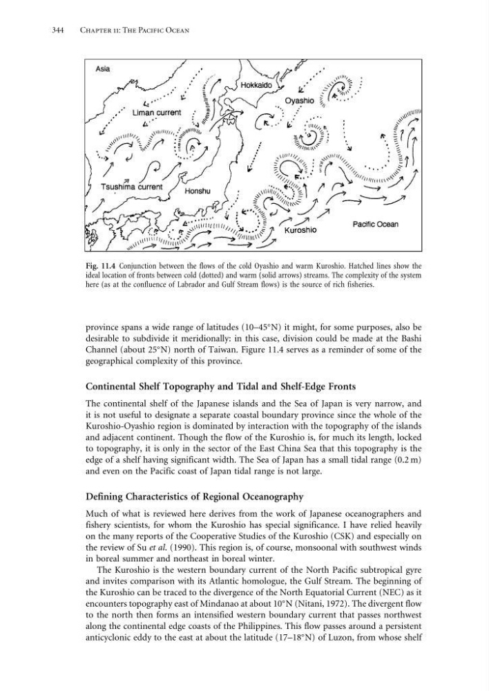
Fig. 11.4 Conjunction between the flows of the cold Oyashio and warm Kuroshio. Hatched lines show the
ideal location of fronts between cold (dotted) and warm (solid arrows) streams. The complexity of the system
here (as at the confluence of Labrador and Gulf Stream flows) is the source of rich fisheries.
province spans a wide range of latitudes (10–45
N) it might, for some purposes, also be
desirable to subdivide it meridionally: in this case, division could be made at the Bashi
Channel (about 25
N) north of Taiwan. Figure 11.4 serves as a reminder of some of the
geographical complexity of this province.
Continental Shelf Topography and Tidal and Shelf-Edge Fronts
The continental shelf of the Japanese islands and the Sea of Japan is very narrow, and
it is not useful to designate a separate coastal boundary province since the whole of the
Kuroshio-Oyashio region is dominated by interaction with the topography of the islands
and adjacent continent. Though the flow of the Kuroshio is, for much its length, locked
to topography, it is only in the sector of the East China Sea that this topography is the
edge of a shelf having significant width. The Sea of Japan has a small tidal range (0.2 m)
and even on the Pacific coast of Japan tidal range is not large.
Defining Characteristics of Regional Oceanography
Much of what is reviewed here derives from the work of Japanese oceanographers and
fishery scientists, for whom the Kuroshio has special significance. I have relied heavily
on the many reports of the Cooperative Studies of the Kuroshio (CSK) and especially on
the review of Su et al. (1990). This region is, of course, monsoonal with southwest winds
in boreal summer and northeast in boreal winter.
The Kuroshio is the western boundary current of the North Pacific subtropical gyre
and invites comparison with its Atlantic homologue, the Gulf Stream. The beginning of
the Kuroshio can be traced to the divergence of the North Equatorial Current (NEC) as it
encounters topography east of Mindanao at about 10
N (Nitani, 1972). The divergent flow
to the north then forms an intensified western boundary current that passes northwest
along the continental edge coasts of the Philippines. This flow passes around a persistent
anticyclonic eddy to the east at about the latitude (17–18
N) of Luzon, from whose shelf
Chapter 11: The Pacific Ocean
Fig. 11.4 Conjunction between the flows of the cold Oyashio and warm Kuroshio. Hatched lines show the
ideal location of fronts between cold (dotted) and warm (solid arrows) streams. The complexity of the system
here (as at the confluence of Labrador and Gulf Stream flows) is the source of rich fisheries.
province spans a wide range of latitudes (10–45
N) it might, for some purposes, also be
desirable to subdivide it meridionally: in this case, division could be made at the Bashi
Channel (about 25
N) north of Taiwan. Figure 11.4 serves as a reminder of some of the
geographical complexity of this province.
Continental Shelf Topography and Tidal and Shelf-Edge Fronts
The continental shelf of the Japanese islands and the Sea of Japan is very narrow, and
it is not useful to designate a separate coastal boundary province since the whole of the
Kuroshio-Oyashio region is dominated by interaction with the topography of the islands
and adjacent continent. Though the flow of the Kuroshio is, for much its length, locked
to topography, it is only in the sector of the East China Sea that this topography is the
edge of a shelf having significant width. The Sea of Japan has a small tidal range (0.2 m)
and even on the Pacific coast of Japan tidal range is not large.
Defining Characteristics of Regional Oceanography
Much of what is reviewed here derives from the work of Japanese oceanographers and
fishery scientists, for whom the Kuroshio has special significance. I have relied heavily
on the many reports of the Cooperative Studies of the Kuroshio (CSK) and especially on
the review of Su et al. (1990). This region is, of course, monsoonal with southwest winds
in boreal summer and northeast in boreal winter.
The Kuroshio is the western boundary current of the North Pacific subtropical gyre
and invites comparison with its Atlantic homologue, the Gulf Stream. The beginning of
the Kuroshio can be traced to the divergence of the North Equatorial Current (NEC) as it
encounters topography east of Mindanao at about 10
N (Nitani, 1972). The divergent flow
to the north then forms an intensified western boundary current that passes northwest
along the continental edge coasts of the Philippines. This flow passes around a persistent
anticyclonic eddy to the east at about the latitude (17–18
N) of Luzon, from whose shelf