

Pacific Westerly Winds Biome
343
0.00
0.22
0.44
0.66
0.88
1.10
0.00
0.20
0.40
0.60
0.80
SeaWiFS (PSAE): September 1997 - January 2002
Surface Chl (mg m -3
)
Pt d
-1
Chl m
-3
Pt (gC m
-2
d
-1
)
1998
1999
2000
2001
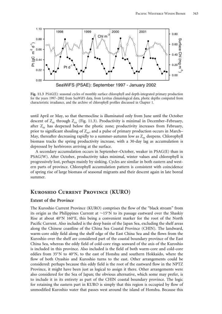
Fig. 11.3 PSAG(E): seasonal cycles of monthly surface chlorophyll and depth-integrated primary production
for the years 1997–2002 from SeaWiFS data, from Levitus climatological data, photic depths computed from
characteristic irradiance, and the archive of chlorophyll profiles discussed in Chapter 1.
until April or May, so that thermocline is illuminated only from June until the October
descent of Z m through Z eu (Fig. 11.3). Productivity is minimal in December–February,
after Z m has deepened below the photic zone; productivity increases from February,
prior to significant shoaling of Z m , and a pulse of primary production occurs in March–
May, thereafter decreasing rapidly to a summer-autumn low as Z m deepens. Chlorophyll
biomass tracks the spring productivity increase, with a 30-day lag as accumulation is
depressed by herbivores arriving at the surface.
A secondary accumulation occurs in September–October, weaker in PSAG(E) than in
PSAG(W). After October, productivity takes minimal, winter values and chlorophyll is
progressively lost, perhaps mainly by sinking. Cycles are similar in both eastern and western parts of province. Chlorophyll accumulation pattern is consistent with coincidence
of spring rise of large biomass of seasonal migrants and their descent again in late boreal
summer.
Kuroshio Current Province (KURO)
Extent of the Province
The Kuroshio Current Province (KURO) comprises the flow of the “black stream” from
its origin as the Philippines Current at ∼15
N to its passage eastward over the Shaskiy
Rise at about 40
N 160
E, this being a convenient marker for the root of the North
Pacific Current. Also included is the deep basin of the Japan Sea, excluding the shelf areas
along the Chinese coastline of the China Sea Coastal Province (CHIN). The landward,
warm-core eddy field along the shelf edge of the East China Sea and the flows from the
Kuroshio over the shelf are considered part of the coastal boundary province of the East
China Sea, whereas the eddy field of cold-core rings seaward of the axis of the Kuroshio
is included in this province. Also included is the field of both warm-core and cold-core
eddies from 35
N to 40
N, to the east of Honshu and southern Hokkaido, where the
flow of both Oyashio and Kuroshio turns to the east. Other arrangements could be
considered: perhaps because this eddy field is the root of the eastward flow in the NPTZ
Province, it might have been just as logical to assign it there. Other arrangements were
also considered for the Sea of Japan; the obvious alternative, which some may prefer, is
to include it in its entirety as part of the CHIN coastal boundary province. The logic
for retaining the eastern part in KURO is simply that this region is occupied by flow of
unmodified Kuroshio water that passes west around the island of Honshu. Because this
343
0.00
0.22
0.44
0.66
0.88
1.10
0.00
0.20
0.40
0.60
0.80
SeaWiFS (PSAE): September 1997 - January 2002
Surface Chl (mg m -3
)
Pt d
-1
Chl m
-3
Pt (gC m
-2
d
-1
)
1998
1999
2000
2001
Fig. 11.3 PSAG(E): seasonal cycles of monthly surface chlorophyll and depth-integrated primary production
for the years 1997–2002 from SeaWiFS data, from Levitus climatological data, photic depths computed from
characteristic irradiance, and the archive of chlorophyll profiles discussed in Chapter 1.
until April or May, so that thermocline is illuminated only from June until the October
descent of Z m through Z eu (Fig. 11.3). Productivity is minimal in December–February,
after Z m has deepened below the photic zone; productivity increases from February,
prior to significant shoaling of Z m , and a pulse of primary production occurs in March–
May, thereafter decreasing rapidly to a summer-autumn low as Z m deepens. Chlorophyll
biomass tracks the spring productivity increase, with a 30-day lag as accumulation is
depressed by herbivores arriving at the surface.
A secondary accumulation occurs in September–October, weaker in PSAG(E) than in
PSAG(W). After October, productivity takes minimal, winter values and chlorophyll is
progressively lost, perhaps mainly by sinking. Cycles are similar in both eastern and western parts of province. Chlorophyll accumulation pattern is consistent with coincidence
of spring rise of large biomass of seasonal migrants and their descent again in late boreal
summer.
Kuroshio Current Province (KURO)
Extent of the Province
The Kuroshio Current Province (KURO) comprises the flow of the “black stream” from
its origin as the Philippines Current at ∼15
N to its passage eastward over the Shaskiy
Rise at about 40
N 160
E, this being a convenient marker for the root of the North
Pacific Current. Also included is the deep basin of the Japan Sea, excluding the shelf areas
along the Chinese coastline of the China Sea Coastal Province (CHIN). The landward,
warm-core eddy field along the shelf edge of the East China Sea and the flows from the
Kuroshio over the shelf are considered part of the coastal boundary province of the East
China Sea, whereas the eddy field of cold-core rings seaward of the axis of the Kuroshio
is included in this province. Also included is the field of both warm-core and cold-core
eddies from 35
N to 40
N, to the east of Honshu and southern Hokkaido, where the
flow of both Oyashio and Kuroshio turns to the east. Other arrangements could be
considered: perhaps because this eddy field is the root of the eastward flow in the NPTZ
Province, it might have been just as logical to assign it there. Other arrangements were
also considered for the Sea of Japan; the obvious alternative, which some may prefer, is
to include it in its entirety as part of the CHIN coastal boundary province. The logic
for retaining the eastern part in KURO is simply that this region is occupied by flow of
unmodified Kuroshio water that passes west around the island of Honshu. Because this