

324
Chapter 10: The Indian Ocean
neritic forms that are recruited to the region of the Java Dome by being drawn through the
interisland passages by the South Equatorial Current that flows strongly westward during
the Southeast Monsoon (see earlier discussion). The typically neritic genera that are
thus transported include Acartia, Eucalanus, Undinula, and Euchaeta. On the Australian
coast, in the southward transport of the coastal segment of the Leeuwin Current, the
tropical-subtropical element of the zooplankton community is progressively eliminated.
Regional Benthic and Demersal Ecology
The Sahul shelf was surveyed in great detail by Okera (1982), who reported on the species
associations of demersal fish but also on the surficial geology. This shelf has complex
topography with sandy ridges at mid-depth, with silty basins between them, and near
the shelf break there are numerous steep-sided banks; shoaler than 40 m, sandy deposits
dominate. Using recurrent group analysis, he identified six assemblages of demersal
species, associating each with its typical depth stratum and deposit type. Because these
statistical groups are common to both the Sahul Shelf and the Gulf of Carpentaria on
the north coast of Australia, I propose to discuss these only in relation to that location
(see SUND province).
Tranter and Leech (1987) suggest that the unusual conditions of the Sahul Shelf
discussed earlier would be expected to lead to an unusually direct utilization of the
primary production by benthic organisms and, hence, by demersal fish. Filter-feeding
benthos of the outer shelf deeper than 40 m, they point out, must have direct and
0
20
40
60
80
100
0
5
10
15
20
25
Climatology (years)
Depth (m)
Production at DCM (%)
Zm (sigma)
Zeu
Pt (at DCM)
0.23
0.35
0.46
0.58
0.70
0.16
0.24
0.32
0.40
0.48
SeaWiFS (AUSW): September 1997 - January 2002
Surface Chl (mg m -3
)
Pt (gC m
-2
d
-1
)
Pt d
-1
Chl m
-3
1998
1999
2000
2001
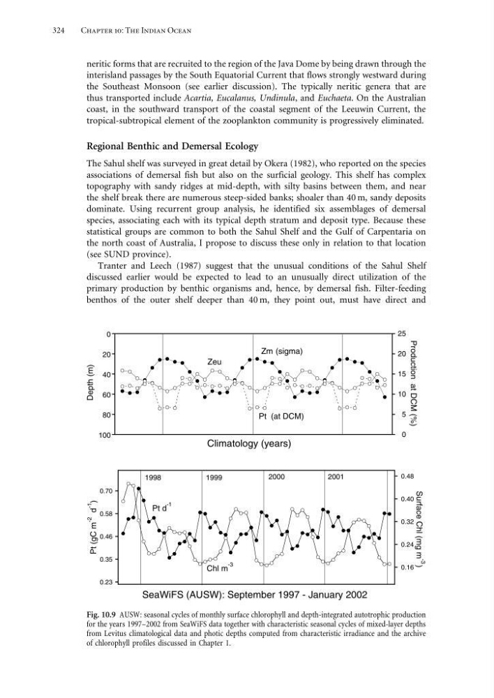
Fig. 10.9 AUSW: seasonal cycles of monthly surface chlorophyll and depth-integrated autotrophic production
for the years 1997–2002 from SeaWiFS data together with characteristic seasonal cycles of mixed-layer depths
from Levitus climatological data and photic depths computed from characteristic irradiance and the archive
of chlorophyll profiles discussed in Chapter 1.
Chapter 10: The Indian Ocean
neritic forms that are recruited to the region of the Java Dome by being drawn through the
interisland passages by the South Equatorial Current that flows strongly westward during
the Southeast Monsoon (see earlier discussion). The typically neritic genera that are
thus transported include Acartia, Eucalanus, Undinula, and Euchaeta. On the Australian
coast, in the southward transport of the coastal segment of the Leeuwin Current, the
tropical-subtropical element of the zooplankton community is progressively eliminated.
Regional Benthic and Demersal Ecology
The Sahul shelf was surveyed in great detail by Okera (1982), who reported on the species
associations of demersal fish but also on the surficial geology. This shelf has complex
topography with sandy ridges at mid-depth, with silty basins between them, and near
the shelf break there are numerous steep-sided banks; shoaler than 40 m, sandy deposits
dominate. Using recurrent group analysis, he identified six assemblages of demersal
species, associating each with its typical depth stratum and deposit type. Because these
statistical groups are common to both the Sahul Shelf and the Gulf of Carpentaria on
the north coast of Australia, I propose to discuss these only in relation to that location
(see SUND province).
Tranter and Leech (1987) suggest that the unusual conditions of the Sahul Shelf
discussed earlier would be expected to lead to an unusually direct utilization of the
primary production by benthic organisms and, hence, by demersal fish. Filter-feeding
benthos of the outer shelf deeper than 40 m, they point out, must have direct and
0
20
40
60
80
100
0
5
10
15
20
25
Climatology (years)
Depth (m)
Production at DCM (%)
Zm (sigma)
Zeu
Pt (at DCM)
0.23
0.35
0.46
0.58
0.70
0.16
0.24
0.32
0.40
0.48
SeaWiFS (AUSW): September 1997 - January 2002
Surface Chl (mg m -3
)
Pt (gC m
-2
d
-1
)
Pt d
-1
Chl m
-3
1998
1999
2000
2001
Fig. 10.9 AUSW: seasonal cycles of monthly surface chlorophyll and depth-integrated autotrophic production
for the years 1997–2002 from SeaWiFS data together with characteristic seasonal cycles of mixed-layer depths
from Levitus climatological data and photic depths computed from characteristic irradiance and the archive
of chlorophyll profiles discussed in Chapter 1.