

268
Chapter 9: The Atlantic Ocean
0
20
40
60
80
100
0
5
10
15
20
Climatology (years)
Depth (m)
Production at DCM (%)
Zm (sigma)
Zeu
Pt (at DCM)
0.30
0.45
0.60
0.75
0.90
0.00
0.30
0.60
0.90
1.20
1.50
SeaWiFS (BRAZ): September 1997 - January 2002
Surface Chl (mg m -3
)
Pt (gC m
-2
d
-1
)
Pt d
-1
Chl m
-3
1998
1999
2000
2001
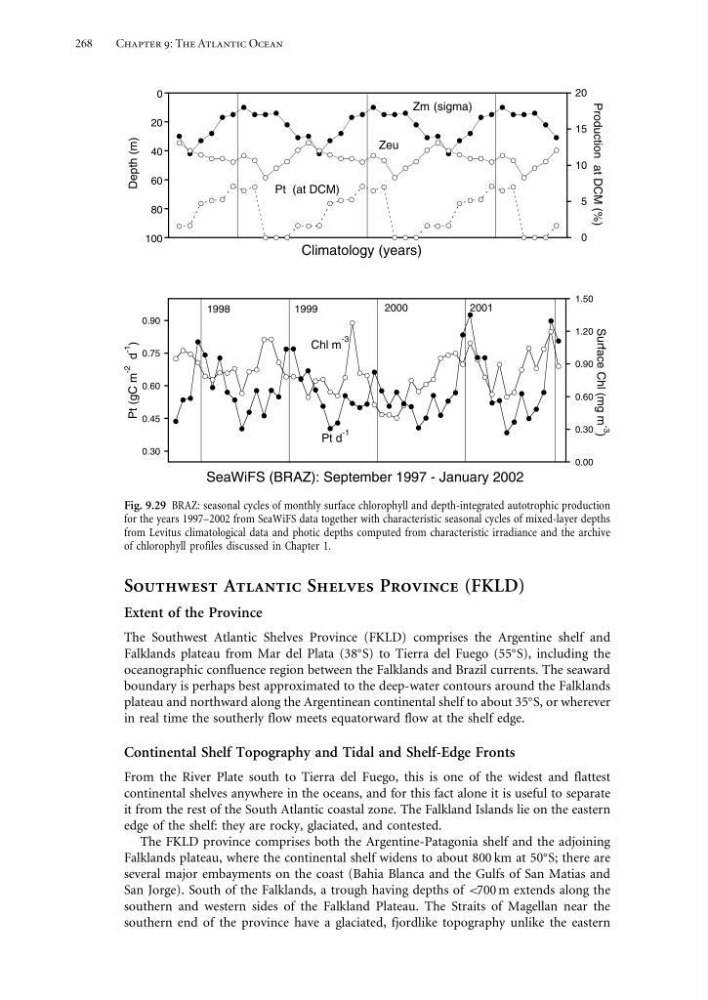
Fig. 9.29 BRAZ: seasonal cycles of monthly surface chlorophyll and depth-integrated autotrophic production
for the years 1997–2002 from SeaWiFS data together with characteristic seasonal cycles of mixed-layer depths
from Levitus climatological data and photic depths computed from characteristic irradiance and the archive
of chlorophyll profiles discussed in Chapter 1.
Southwest Atlantic Shelves Province (FKLD)
Extent of the Province
The Southwest Atlantic Shelves Province (FKLD) comprises the Argentine shelf and
Falklands plateau from Mar del Plata (38
S) to Tierra del Fuego (55
S), including the
oceanographic confluence region between the Falklands and Brazil currents. The seaward
boundary is perhaps best approximated to the deep-water contours around the Falklands
plateau and northward along the Argentinean continental shelf to about 35
S, or wherever
in real time the southerly flow meets equatorward flow at the shelf edge.
Continental Shelf Topography and Tidal and Shelf-Edge Fronts
From the River Plate south to Tierra del Fuego, this is one of the widest and flattest
continental shelves anywhere in the oceans, and for this fact alone it is useful to separate
it from the rest of the South Atlantic coastal zone. The Falkland Islands lie on the eastern
edge of the shelf: they are rocky, glaciated, and contested.
The FKLD province comprises both the Argentine-Patagonia shelf and the adjoining
Falklands plateau, where the continental shelf widens to about 800 km at 50
S; there are
several major embayments on the coast (Bahia Blanca and the Gulfs of San Matias and
San Jorge). South of the Falklands, a trough having depths of <700 m extends along the
southern and western sides of the Falkland Plateau. The Straits of Magellan near the
southern end of the province have a glaciated, fjordlike topography unlike the eastern
Chapter 9: The Atlantic Ocean
0
20
40
60
80
100
0
5
10
15
20
Climatology (years)
Depth (m)
Production at DCM (%)
Zm (sigma)
Zeu
Pt (at DCM)
0.30
0.45
0.60
0.75
0.90
0.00
0.30
0.60
0.90
1.20
1.50
SeaWiFS (BRAZ): September 1997 - January 2002
Surface Chl (mg m -3
)
Pt (gC m
-2
d
-1
)
Pt d
-1
Chl m
-3
1998
1999
2000
2001
Fig. 9.29 BRAZ: seasonal cycles of monthly surface chlorophyll and depth-integrated autotrophic production
for the years 1997–2002 from SeaWiFS data together with characteristic seasonal cycles of mixed-layer depths
from Levitus climatological data and photic depths computed from characteristic irradiance and the archive
of chlorophyll profiles discussed in Chapter 1.
Southwest Atlantic Shelves Province (FKLD)
Extent of the Province
The Southwest Atlantic Shelves Province (FKLD) comprises the Argentine shelf and
Falklands plateau from Mar del Plata (38
S) to Tierra del Fuego (55
S), including the
oceanographic confluence region between the Falklands and Brazil currents. The seaward
boundary is perhaps best approximated to the deep-water contours around the Falklands
plateau and northward along the Argentinean continental shelf to about 35
S, or wherever
in real time the southerly flow meets equatorward flow at the shelf edge.
Continental Shelf Topography and Tidal and Shelf-Edge Fronts
From the River Plate south to Tierra del Fuego, this is one of the widest and flattest
continental shelves anywhere in the oceans, and for this fact alone it is useful to separate
it from the rest of the South Atlantic coastal zone. The Falkland Islands lie on the eastern
edge of the shelf: they are rocky, glaciated, and contested.
The FKLD province comprises both the Argentine-Patagonia shelf and the adjoining
Falklands plateau, where the continental shelf widens to about 800 km at 50
S; there are
several major embayments on the coast (Bahia Blanca and the Gulfs of San Matias and
San Jorge). South of the Falklands, a trough having depths of <700 m extends along the
southern and western sides of the Falkland Plateau. The Straits of Magellan near the
southern end of the province have a glaciated, fjordlike topography unlike the eastern