

57
How Can Data Be Georeferenced?
the unreferenced data to the source data, they have to be placed in the
same location in both sets of data, and real-world coordinates for these
points will be required. By finding these same locations on the source (that
has real-world coordinates) and on the unreferenced data (without them),
we can start to match the two datasets together. Thus, places where you
can clearly find the same spot in the unreferenced data and the source data
will be good choices for the placement of control points in that location.
For instance, the intersections of roads or the corners of buildings are welldefined areas that can be found on both sets of data and would make good
control point locations. These are also locations that aren’t likely to change
over time, so even if the unreferenced data and the source aren’t from the
same time period, they would still be valid as control point selections. Poor
locations for control point selection spots are those that can’t be accurately
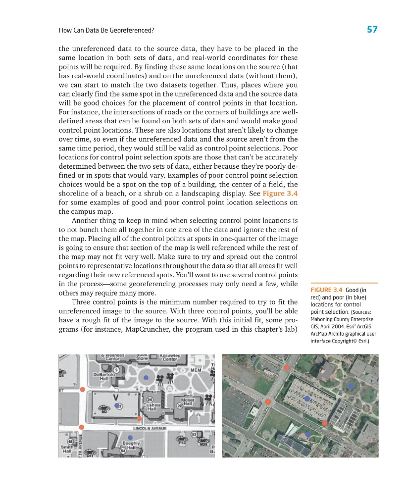
determined between the two sets of data, either because they’re poorly defined or in spots that would vary. Examples of poor control point selection
choices would be a spot on the top of a building, the center of a field, the
shoreline of a beach, or a shrub on a landscaping display. See Figure 3.4
for some examples of good and poor control point location selections on
the campus map.
Another thing to keep in mind when selecting control point locations is
to not bunch them all together in one area of the data and ignore the rest of
the map. Placing all of the control points at spots in one-quarter of the image
is going to ensure that section of the map is well referenced while the rest of
the map may not fit very well. Make sure to try and spread out the control
points to representative locations throughout the data so that all areas fit well
regarding their new referenced spots. You’ll want to use several control points
in the process—some georeferencing processes may only need a few, while
others may require many more.
Three control points is the minimum number required to try to fit the
unreferenced image to the source. With three control points, you’ll be able
have a rough fit of the image to the source. With this initial fit, some programs (for instance, MapCruncher, the program used in this chapter’s lab)
FIGURE 3.4 Good (in
red) and poor (in blue)
locations for control
point selection. (Sources:
Mahoning County Enterprise
GIS, April 2004. Esri
® ArcGIS
ArcMap ArcInfo graphical user
interface Copyright© Esri.)
How Can Data Be Georeferenced?
the unreferenced data to the source data, they have to be placed in the
same location in both sets of data, and real-world coordinates for these
points will be required. By finding these same locations on the source (that
has real-world coordinates) and on the unreferenced data (without them),
we can start to match the two datasets together. Thus, places where you
can clearly find the same spot in the unreferenced data and the source data
will be good choices for the placement of control points in that location.
For instance, the intersections of roads or the corners of buildings are welldefined areas that can be found on both sets of data and would make good
control point locations. These are also locations that aren’t likely to change
over time, so even if the unreferenced data and the source aren’t from the
same time period, they would still be valid as control point selections. Poor
locations for control point selection spots are those that can’t be accurately
determined between the two sets of data, either because they’re poorly defined or in spots that would vary. Examples of poor control point selection
choices would be a spot on the top of a building, the center of a field, the
shoreline of a beach, or a shrub on a landscaping display. See Figure 3.4
for some examples of good and poor control point location selections on
the campus map.
Another thing to keep in mind when selecting control point locations is
to not bunch them all together in one area of the data and ignore the rest of
the map. Placing all of the control points at spots in one-quarter of the image
is going to ensure that section of the map is well referenced while the rest of
the map may not fit very well. Make sure to try and spread out the control
points to representative locations throughout the data so that all areas fit well
regarding their new referenced spots. You’ll want to use several control points
in the process—some georeferencing processes may only need a few, while
others may require many more.
Three control points is the minimum number required to try to fit the
unreferenced image to the source. With three control points, you’ll be able
have a rough fit of the image to the source. With this initial fit, some programs (for instance, MapCruncher, the program used in this chapter’s lab)
FIGURE 3.4 Good (in
red) and poor (in blue)
locations for control
point selection. (Sources:
Mahoning County Enterprise
GIS, April 2004. Esri
® ArcGIS
ArcMap ArcInfo graphical user
interface Copyright© Esri.)