

49
Coordinates and Position Measurements
distance between two sets of lat/long coordinates (and also between two
cities) in DMS format.
15. Use your answer to Question 2.1 as the Degrees, Minutes, and Seconds
for the Latitude and Longitude of Point one (you are using North
latitude and West longitude).
16. Use your answer to Question 2.4 as the Degrees, Minutes, and Seconds
for the Latitude and Longitude of Point two (you are again using North
latitude and West longitude).
17. Click the Distance Between button. The surface distance between the
two points will be computed in kilometers, miles, and nautical miles.
Answer Question 2.7. Your answers to Questions 2.5 and 2.7 should be
relatively similar given how they were both computed—if they’re really
way off, re-do your Question 2.5 measurement and make sure you’re
inputting the correct numbers for Question 2.7.
Question 2.7 According to this Website measurement, what is the
computed surface distance (in miles) between the White House and
Buckingham Palace?
2.2 Using UTM Coordinates and Measurements
in Google Earth
Universal Transverse Mercator (UTM) is a projected coordinate system and
GE can track coordinates using this UTM system as well as lat/long.
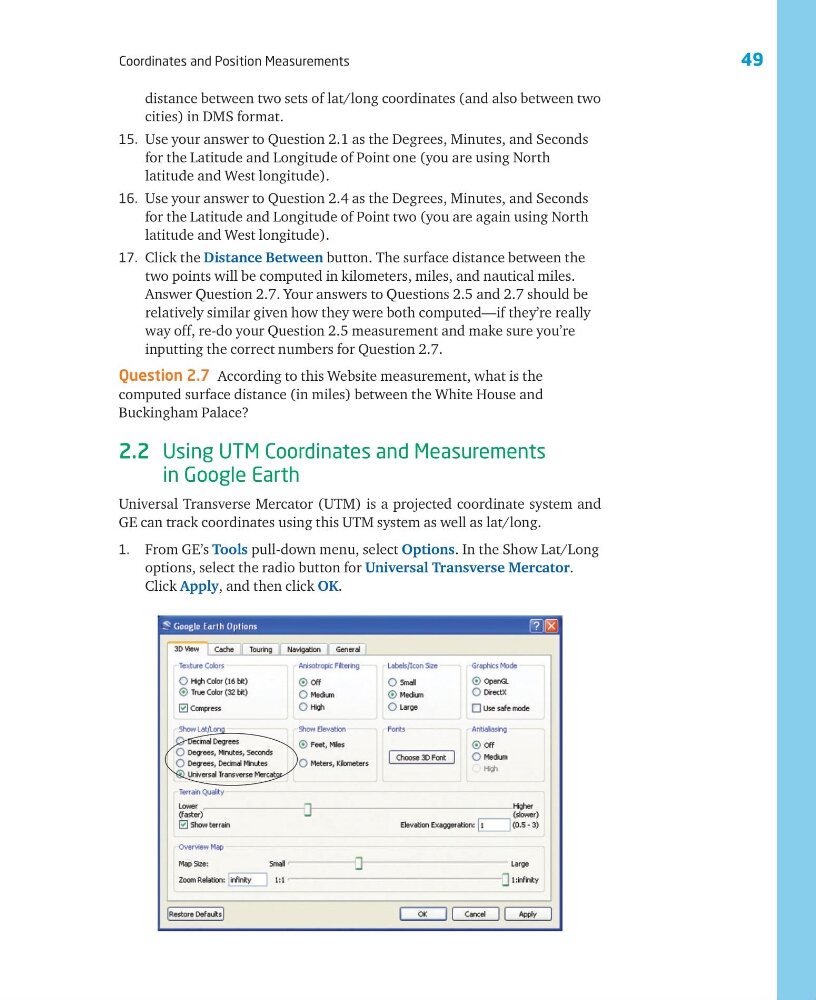
1. From GE’s Tools pull-down menu, select Options. In the Show Lat/Long
options, select the radio button for Universal Transverse Mercator.
Click Apply, and then click OK.
Coordinates and Position Measurements
distance between two sets of lat/long coordinates (and also between two
cities) in DMS format.
15. Use your answer to Question 2.1 as the Degrees, Minutes, and Seconds
for the Latitude and Longitude of Point one (you are using North
latitude and West longitude).
16. Use your answer to Question 2.4 as the Degrees, Minutes, and Seconds
for the Latitude and Longitude of Point two (you are again using North
latitude and West longitude).
17. Click the Distance Between button. The surface distance between the
two points will be computed in kilometers, miles, and nautical miles.
Answer Question 2.7. Your answers to Questions 2.5 and 2.7 should be
relatively similar given how they were both computed—if they’re really
way off, re-do your Question 2.5 measurement and make sure you’re
inputting the correct numbers for Question 2.7.
Question 2.7 According to this Website measurement, what is the
computed surface distance (in miles) between the White House and
Buckingham Palace?
2.2 Using UTM Coordinates and Measurements
in Google Earth
Universal Transverse Mercator (UTM) is a projected coordinate system and
GE can track coordinates using this UTM system as well as lat/long.
1. From GE’s Tools pull-down menu, select Options. In the Show Lat/Long
options, select the radio button for Universal Transverse Mercator.
Click Apply, and then click OK.