

32
Chapter 2 Where in the Geospatial World Are You?
the Equator being numbers read as south latitude. Lines of longitude (also
called meridians) run north-to-south from the North Pole to the South Pole.
The Prime Meridian (the line of longitude that runs through Greenwich,
England) serves as the starting point of zero. Measurements made east of
the Prime Meridian are numbers read as east longitude, while measurements
made west of the Prime Meridian are numbers read as west longitude. The
breaking point between east and west longitude is the 180th meridian, also
referred to as the International Date Line.
Using this system (where measurements are made north or south of the
Equator and east or west of the Prime Meridian), any point on the globe can
be located. GCS measurements are not made in feet or meters or miles, but
rather they are in degrees, minutes, and seconds (DMS). A degree is a unit
of measurement that can be broken into 60 subsections (each one referred to
as a minute of distance). A minute can be subsequently broken down into 60
subsections (each one referred to as a second of distance). A single minute of
latitude is equivalent to roughly one nautical mile (or about 1.15 miles). However, the distance between degrees of longitude varies across the globe as lines
of longitude are closer together at the poles and further apart at the Equator.
When GCS coordinates are being written for a location, they are in terms
of how far the distance (that is, in terms of degrees, minutes, and seconds)
is from the Equator and the Prime Meridian. Latitude values run from 0 to
90 degrees north and south of the Equator, while longitude values run from
0 to 180 east and west of the Prime Meridian. For example, the GCS coordinates of a spot at the Mount Rushmore National Monument are 43 degrees,
52 minutes, 53.38 seconds north of the Equator (43°52′53.38″ N latitude)
longitude imaginary
lines on a globe east
and west of the
Prime Meridian that
serve as a basis of
measurement in GCS.
Prime Meridian the
line of longitude
that runs through
Greenwich, England, and
serves as the 0 degree
line of longitude to base
measurements from.
International Date
Line a line of longitude
that follows a similar
path as the 180th
meridian (but changes
away from a straight
line to accommodate
geography).
degrees, minutes, and
seconds (DMS) the
measurement system
used in GCS.
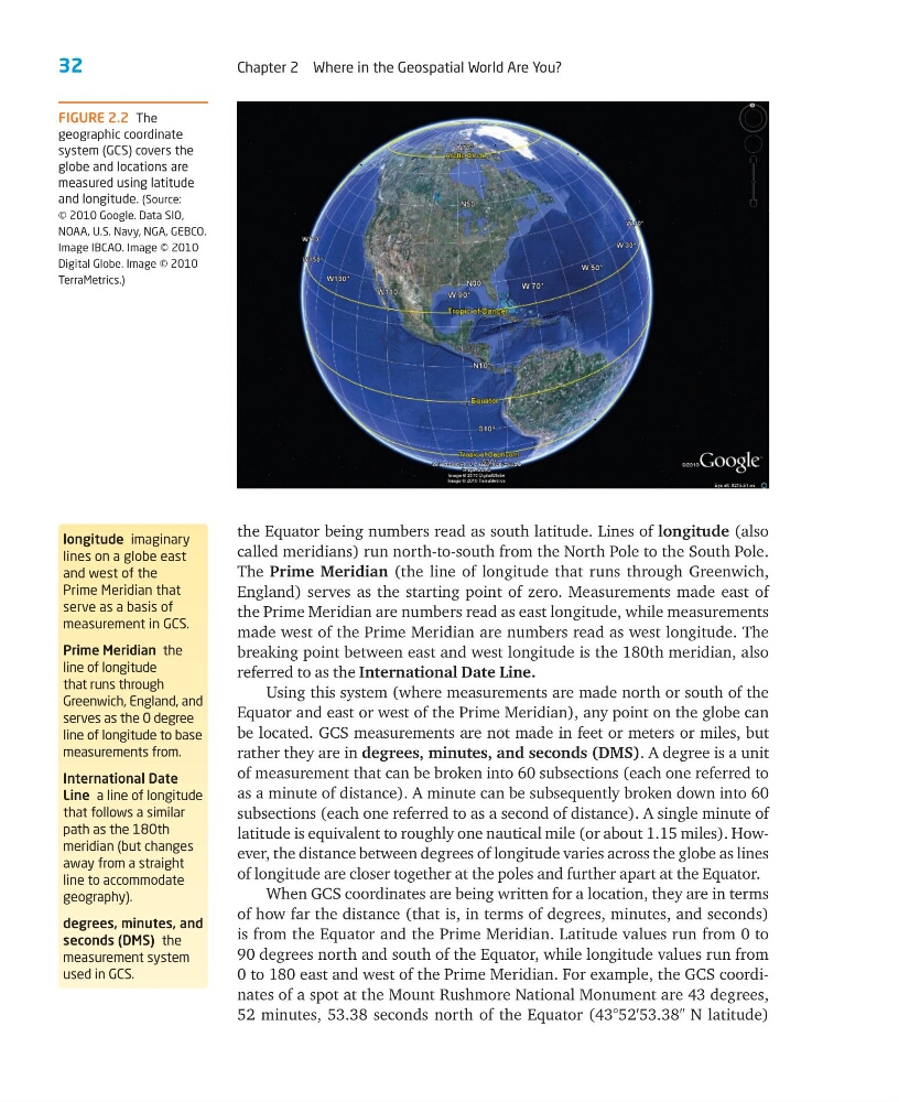
FIGURE 2.2 The
geographic coordinate
system (GCS) covers the
globe and locations are
measured using latitude
and longitude. (Source:
© 2010 Google. Data SIO,
NOAA, U.S. Navy, NGA, GEBCO.
Image IBCAO. Image © 2010
Digital Globe. Image © 2010
TerraMetrics.)
Chapter 2 Where in the Geospatial World Are You?
the Equator being numbers read as south latitude. Lines of longitude (also
called meridians) run north-to-south from the North Pole to the South Pole.
The Prime Meridian (the line of longitude that runs through Greenwich,
England) serves as the starting point of zero. Measurements made east of
the Prime Meridian are numbers read as east longitude, while measurements
made west of the Prime Meridian are numbers read as west longitude. The
breaking point between east and west longitude is the 180th meridian, also
referred to as the International Date Line.
Using this system (where measurements are made north or south of the
Equator and east or west of the Prime Meridian), any point on the globe can
be located. GCS measurements are not made in feet or meters or miles, but
rather they are in degrees, minutes, and seconds (DMS). A degree is a unit
of measurement that can be broken into 60 subsections (each one referred to
as a minute of distance). A minute can be subsequently broken down into 60
subsections (each one referred to as a second of distance). A single minute of
latitude is equivalent to roughly one nautical mile (or about 1.15 miles). However, the distance between degrees of longitude varies across the globe as lines
of longitude are closer together at the poles and further apart at the Equator.
When GCS coordinates are being written for a location, they are in terms
of how far the distance (that is, in terms of degrees, minutes, and seconds)
is from the Equator and the Prime Meridian. Latitude values run from 0 to
90 degrees north and south of the Equator, while longitude values run from
0 to 180 east and west of the Prime Meridian. For example, the GCS coordinates of a spot at the Mount Rushmore National Monument are 43 degrees,
52 minutes, 53.38 seconds north of the Equator (43°52′53.38″ N latitude)
longitude imaginary
lines on a globe east
and west of the
Prime Meridian that
serve as a basis of
measurement in GCS.
Prime Meridian the
line of longitude
that runs through
Greenwich, England, and
serves as the 0 degree
line of longitude to base
measurements from.
International Date
Line a line of longitude
that follows a similar
path as the 180th
meridian (but changes
away from a straight
line to accommodate
geography).
degrees, minutes, and
seconds (DMS) the
measurement system
used in GCS.
FIGURE 2.2 The
geographic coordinate
system (GCS) covers the
globe and locations are
measured using latitude
and longitude. (Source:
© 2010 Google. Data SIO,
NOAA, U.S. Navy, NGA, GEBCO.
Image IBCAO. Image © 2010
Digital Globe. Image © 2010
TerraMetrics.)