

30
Chapter 2 Where in the Geospatial World Are You?
assigning location information to the data being handled. Every location on
Earth has to be referenced in some way. In other words, every location has to
be identified and measured. Second, these measurements require some sort
of reference system so that locations at one point on Earth can be compared
with locations at another area. Third, since we’re dealing with points on a
three-dimensional (3D) Earth but we only have a two-dimensional (2D) surface to examine (like a map), there has to be a way of translating real-world
data to an environment we can use. This chapter examines how these concepts are treated in all forms of geospatial technology. If you’re going to be
able to precisely pin down the coordinates of a location, you’ll need to first
have a datum and a coordinate system.
What Is a Datum?
A datum is a reference surface, or model of Earth that is used for plotting
locations across the globe. The datum represents the size and shape of Earth,
which, contrary to popular belief, isn’t perfectly round. Earth is actually an
ellipsoid (or spheroid) shape, meaning that it’s larger at its center than it is
at its poles. Think of taking a basketball and squeezing the top and bottom of
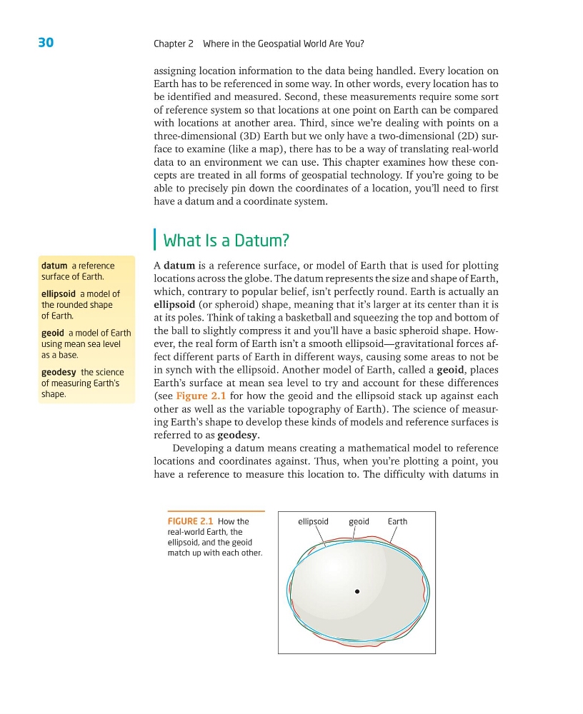
the ball to slightly compress it and you’ll have a basic spheroid shape. However, the real form of Earth isn’t a smooth ellipsoid— gravitational forces affect different parts of Earth in different ways, causing some areas to not be
in synch with the ellipsoid. Another model of Earth, called a geoid, places
Earth’s surface at mean sea level to try and account for these differences
(see Figure 2.1 for how the geoid and the ellipsoid stack up against each
other as well as the variable topography of Earth). The science of measuring Earth’s shape to develop these kinds of models and reference surfaces is
referred to as geodesy.
Developing a datum means creating a mathematical model to reference
locations and coordinates against. Thus, when you’re plotting a point, you
have a reference to measure this location to. The difficulty with datums in
datum a reference
surface of Earth.
ellipsoid a model of
the rounded shape
of Earth.
geoid a model of Earth
using mean sea level
as a base.
geodesy the science
of measuring Earth’s
shape.
FIGURE 2.1 How the
real-world Earth, the
ellipsoid, and the geoid
match up with each other.
ellipsoid
geoid
Earth
Chapter 2 Where in the Geospatial World Are You?
assigning location information to the data being handled. Every location on
Earth has to be referenced in some way. In other words, every location has to
be identified and measured. Second, these measurements require some sort
of reference system so that locations at one point on Earth can be compared
with locations at another area. Third, since we’re dealing with points on a
three-dimensional (3D) Earth but we only have a two-dimensional (2D) surface to examine (like a map), there has to be a way of translating real-world
data to an environment we can use. This chapter examines how these concepts are treated in all forms of geospatial technology. If you’re going to be
able to precisely pin down the coordinates of a location, you’ll need to first
have a datum and a coordinate system.
What Is a Datum?
A datum is a reference surface, or model of Earth that is used for plotting
locations across the globe. The datum represents the size and shape of Earth,
which, contrary to popular belief, isn’t perfectly round. Earth is actually an
ellipsoid (or spheroid) shape, meaning that it’s larger at its center than it is
at its poles. Think of taking a basketball and squeezing the top and bottom of
the ball to slightly compress it and you’ll have a basic spheroid shape. However, the real form of Earth isn’t a smooth ellipsoid— gravitational forces affect different parts of Earth in different ways, causing some areas to not be
in synch with the ellipsoid. Another model of Earth, called a geoid, places
Earth’s surface at mean sea level to try and account for these differences
(see Figure 2.1 for how the geoid and the ellipsoid stack up against each
other as well as the variable topography of Earth). The science of measuring Earth’s shape to develop these kinds of models and reference surfaces is
referred to as geodesy.
Developing a datum means creating a mathematical model to reference
locations and coordinates against. Thus, when you’re plotting a point, you
have a reference to measure this location to. The difficulty with datums in
datum a reference
surface of Earth.
ellipsoid a model of
the rounded shape
of Earth.
geoid a model of Earth
using mean sea level
as a base.
geodesy the science
of measuring Earth’s
shape.
FIGURE 2.1 How the
real-world Earth, the
ellipsoid, and the geoid
match up with each other.
ellipsoid
geoid
Earth