

442
Chapter 15 What’s Next for Geospatial Technology?
to download Landsat scenes of Ohio via NASA Glenn in Cleveland (and also
via OhioView’s Website). OhioView serves as a consortium for remote sensing
and geospatial research and is composed of members from each of the state
universities in Ohio, along with other partners such as the Ohio Aerospace
Institute. With all of these statewide affiliations, OhioView serves as a source
of many initiatives within the state, including educational efforts.
This type of statewide consortium may have originated with OhioView
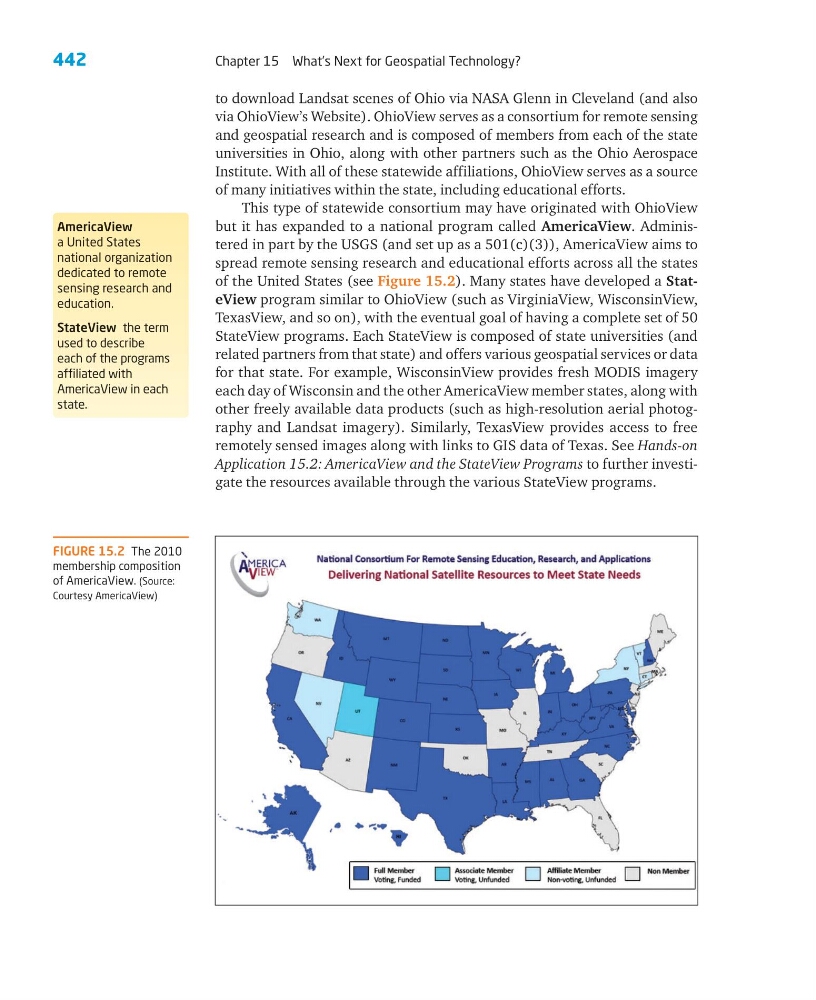
but it has expanded to a national program called AmericaView. Administered in part by the USGS (and set up as a 501(c)(3)), AmericaView aims to
spread remote sensing research and educational efforts across all the states
of the United States (see Figure 15.2). Many states have developed a StateView program similar to OhioView (such as VirginiaView, WisconsinView,
TexasView, and so on), with the eventual goal of having a complete set of 50
StateView programs. Each StateView is composed of state universities (and
related partners from that state) and offers various geospatial services or data
for that state. For example, WisconsinView provides fresh MODIS imagery
each day of Wisconsin and the other AmericaView member states, along with
other freely available data products (such as high-resolution aerial photography and Landsat imagery). Similarly, TexasView provides access to free
remotely sensed images along with links to GIS data of Texas. See Hands-on
Application 15.2: AmericaView and the StateView Programs to further investigate the resources available through the various StateView programs.
AmericaView
a United States
national organization
dedicated to remote
sensing research and
education.
StateView the term
used to describe
each of the programs
affiliated with
AmericaView in each
state.
FIGURE 15.2 The 2010
membership composition
of AmericaView. (Source:
Courtesy AmericaView)
Chapter 15 What’s Next for Geospatial Technology?
to download Landsat scenes of Ohio via NASA Glenn in Cleveland (and also
via OhioView’s Website). OhioView serves as a consortium for remote sensing
and geospatial research and is composed of members from each of the state
universities in Ohio, along with other partners such as the Ohio Aerospace
Institute. With all of these statewide affiliations, OhioView serves as a source
of many initiatives within the state, including educational efforts.
This type of statewide consortium may have originated with OhioView
but it has expanded to a national program called AmericaView. Administered in part by the USGS (and set up as a 501(c)(3)), AmericaView aims to
spread remote sensing research and educational efforts across all the states
of the United States (see Figure 15.2). Many states have developed a StateView program similar to OhioView (such as VirginiaView, WisconsinView,
TexasView, and so on), with the eventual goal of having a complete set of 50
StateView programs. Each StateView is composed of state universities (and
related partners from that state) and offers various geospatial services or data
for that state. For example, WisconsinView provides fresh MODIS imagery
each day of Wisconsin and the other AmericaView member states, along with
other freely available data products (such as high-resolution aerial photography and Landsat imagery). Similarly, TexasView provides access to free
remotely sensed images along with links to GIS data of Texas. See Hands-on
Application 15.2: AmericaView and the StateView Programs to further investigate the resources available through the various StateView programs.
AmericaView
a United States
national organization
dedicated to remote
sensing research and
education.
StateView the term
used to describe
each of the programs
affiliated with
AmericaView in each
state.
FIGURE 15.2 The 2010
membership composition
of AmericaView. (Source:
Courtesy AmericaView)