

340
Chapter 11 Images from Space
with 0.5-meter spatial resolution. DigitalGlobe also launched WorldView-2
in October 2009 with 0.46-meter panchromatic and 1.84-meter 8-band multispectral spatial resolution.
The highest spatial resolution imagery currently commercially available
is from the sensors onboard the GeoEye-1 satellite, launched in 2008 by
the GeoEye company. GeoEye-1 has two sensors, a four-band multispectral
(blue, green, red, and near infrared) with 1.65-meter spatial resolution and a
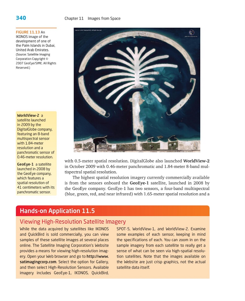
FIGURE 11.13 An
IKONOS image of the
development of one of
the Palm Islands in Dubai,
United Arab Emirates.
(Source: Satellite Imaging
Corporation Copyright ©
2007 GeoEye/SIME. All Rights
Reserved.)
While the data acquired by satellites like IKONOS
and QuickBird is sold commercially, you can view
samples of these satellite images at several places
online. The Satellite Imaging Corporation’s Website
provides a means for viewing high-resolution imagery. Open your Web browser and go to http://www.
satimagingcorp.com. Select the option for Gallery,
and then select High-Resolution Sensors. Available
imagery includes GeoEye-1, IKONOS, QuickBird,
SPOT-5, WorldView-1, and WorldView-2. Examine
some examples of each sensor, keeping in mind
the specifications of each. You can zoom in on the
sample imagery from each satellite to really get a
sense of what can be seen via high-spatial resolution satellites. Note that the images available on
the Website are just crisp graphics, not the actual
satellite data itself.
Hands-on Application 11.5
Viewing High-Resolution Satellite Imagery
WorldView-2 a
satellite launched
in 2009 by the
DigitalGlobe company,
featuring an 8-band
multispectral sensor
with 1.84-meter
resolution and a
panchromatic sensor of
0.46-meter resolution.
GeoEye-1 a satellite
launched in 2008 by
the GeoEye company,
which features a
spatial resolution of
41 centimeters with its
panchromatic sensor.
Chapter 11 Images from Space
with 0.5-meter spatial resolution. DigitalGlobe also launched WorldView-2
in October 2009 with 0.46-meter panchromatic and 1.84-meter 8-band multispectral spatial resolution.
The highest spatial resolution imagery currently commercially available
is from the sensors onboard the GeoEye-1 satellite, launched in 2008 by
the GeoEye company. GeoEye-1 has two sensors, a four-band multispectral
(blue, green, red, and near infrared) with 1.65-meter spatial resolution and a
FIGURE 11.13 An
IKONOS image of the
development of one of
the Palm Islands in Dubai,
United Arab Emirates.
(Source: Satellite Imaging
Corporation Copyright ©
2007 GeoEye/SIME. All Rights
Reserved.)
While the data acquired by satellites like IKONOS
and QuickBird is sold commercially, you can view
samples of these satellite images at several places
online. The Satellite Imaging Corporation’s Website
provides a means for viewing high-resolution imagery. Open your Web browser and go to http://www.
satimagingcorp.com. Select the option for Gallery,
and then select High-Resolution Sensors. Available
imagery includes GeoEye-1, IKONOS, QuickBird,
SPOT-5, WorldView-1, and WorldView-2. Examine
some examples of each sensor, keeping in mind
the specifications of each. You can zoom in on the
sample imagery from each satellite to really get a
sense of what can be seen via high-spatial resolution satellites. Note that the images available on
the Website are just crisp graphics, not the actual
satellite data itself.
Hands-on Application 11.5
Viewing High-Resolution Satellite Imagery
WorldView-2 a
satellite launched
in 2009 by the
DigitalGlobe company,
featuring an 8-band
multispectral sensor
with 1.84-meter
resolution and a
panchromatic sensor of
0.46-meter resolution.
GeoEye-1 a satellite
launched in 2008 by
the GeoEye company,
which features a
spatial resolution of
41 centimeters with its
panchromatic sensor.