

337
What Is a Landsat Satellite and What Does It Do?
scientists can find clues to understanding the spread of phytoplankton in
coastal waters, enabling environmentalists to try and head off potential algae blooms or red-tide conditions. Threats to animal habitats can be assessed
through forest or wetland monitoring via Landsat imagery; Landsat images
also allow scientists to track the movements of invasive species that threaten
timber industries. Hands-on Application 11.4: Applications of Landsat Imagery
lets you dig further into the myriad uses of Landsat remote sensing.
NASA also operates a remote sensing project with capabilities related to
the Landsat program. EO-1 (Earth Observing 1) was launched in 2000 as part
of NASA’s New Millennium Program and placed in orbit so it was traveling
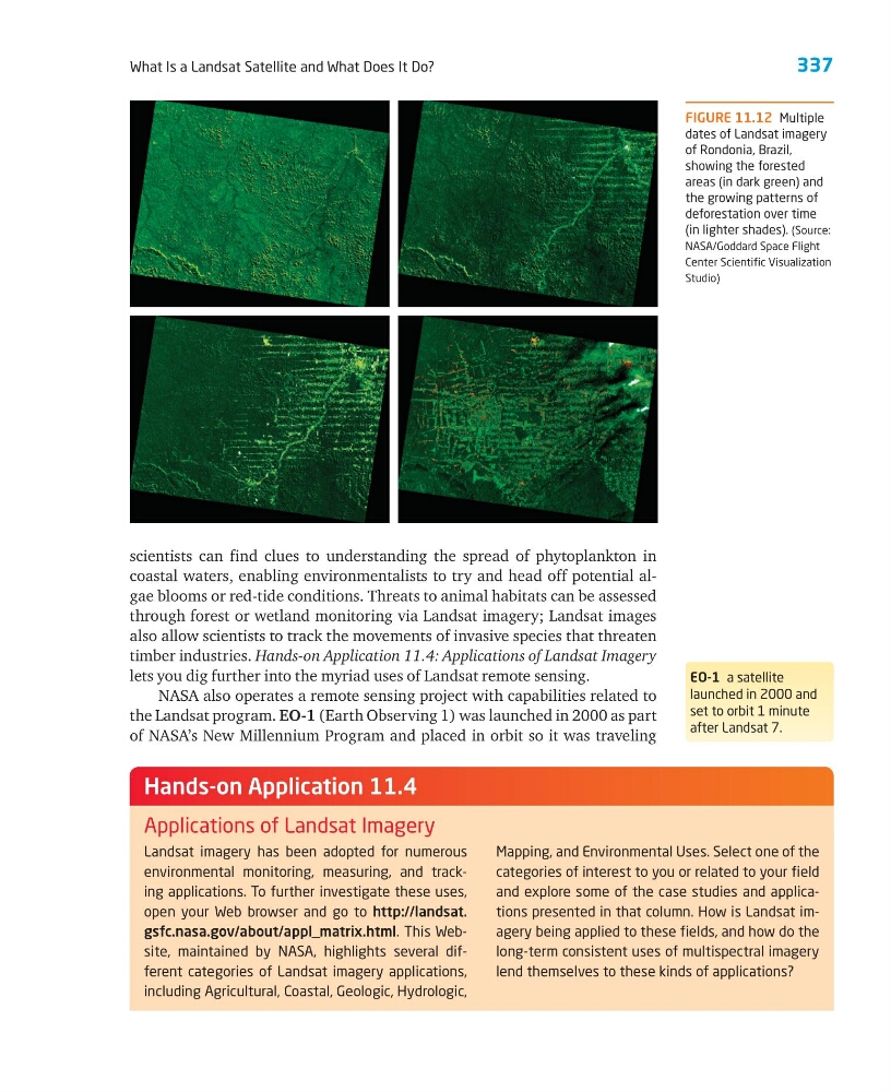
FIGURE 11.12 Multiple
dates of Landsat imagery
of Rondonia, Brazil,
showing the forested
areas (in dark green) and
the growing patterns of
deforestation over time
(in lighter shades). (Source:
NASA/Goddard Space Flight
Center Scientific Visualization
Studio)
Landsat imagery has been adopted for numerous
environmental monitoring, measuring, and tracking applications. To further investigate these uses,
open your Web browser and go to http://landsat.
gsfc.nasa.gov/about/appl_matrix.html. This Website, maintained by NASA, highlights several different categories of Landsat imagery applications,
including Agricultural, Coastal, Geologic, Hydrologic,
Mapping, and Environmental Uses. Select one of the
categories of interest to you or related to your field
and explore some of the case studies and applications presented in that column. How is Landsat imagery being applied to these fields, and how do the
long-term consistent uses of multispectral imagery
lend themselves to these kinds of applications?
Hands-on Application 11.4
Applications of Landsat Imagery
EO-1 a satellite
launched in 2000 and
set to orbit 1 minute
after Landsat 7.
What Is a Landsat Satellite and What Does It Do?
scientists can find clues to understanding the spread of phytoplankton in
coastal waters, enabling environmentalists to try and head off potential algae blooms or red-tide conditions. Threats to animal habitats can be assessed
through forest or wetland monitoring via Landsat imagery; Landsat images
also allow scientists to track the movements of invasive species that threaten
timber industries. Hands-on Application 11.4: Applications of Landsat Imagery
lets you dig further into the myriad uses of Landsat remote sensing.
NASA also operates a remote sensing project with capabilities related to
the Landsat program. EO-1 (Earth Observing 1) was launched in 2000 as part
of NASA’s New Millennium Program and placed in orbit so it was traveling
FIGURE 11.12 Multiple
dates of Landsat imagery
of Rondonia, Brazil,
showing the forested
areas (in dark green) and
the growing patterns of
deforestation over time
(in lighter shades). (Source:
NASA/Goddard Space Flight
Center Scientific Visualization
Studio)
Landsat imagery has been adopted for numerous
environmental monitoring, measuring, and tracking applications. To further investigate these uses,
open your Web browser and go to http://landsat.
gsfc.nasa.gov/about/appl_matrix.html. This Website, maintained by NASA, highlights several different categories of Landsat imagery applications,
including Agricultural, Coastal, Geologic, Hydrologic,
Mapping, and Environmental Uses. Select one of the
categories of interest to you or related to your field
and explore some of the case studies and applications presented in that column. How is Landsat imagery being applied to these fields, and how do the
long-term consistent uses of multispectral imagery
lend themselves to these kinds of applications?
Hands-on Application 11.4
Applications of Landsat Imagery
EO-1 a satellite
launched in 2000 and
set to orbit 1 minute
after Landsat 7.