

290
Chapter 9 Remotely Sensed Images from Above
9.1 Applying Elements of Visual Image Interpretation
Take a look at each one of the images (there are questions related to each
further down) and try to determine just what it is you’re looking at. Although
everyone’s application of the elements may vary, there are some guidelines
that you may find useful in interpreting the images.
Several images may contain multiple items, but all of them work together
to help define one key solution.
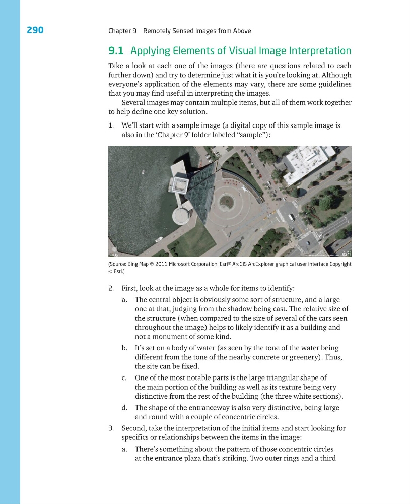
1. We’ll start with a sample image (a digital copy of this sample image is
also in the ‘Chapter 9’ folder labeled “sample”):
(Source: Bing Map © 2011 Microsoft Corporation. Esri® ArcGIS ArcExplorer graphical user interface Copyright
© Esri.)
2. First, look at the image as a whole for items to identify:
a. The central object is obviously some sort of structure, and a large
one at that, judging from the shadow being cast. The relative size of
the structure (when compared to the size of several of the cars seen
throughout the image) helps to likely identify it as a building and
not a monument of some kind.
b. It’s set on a body of water (as seen by the tone of the water being
different from the tone of the nearby concrete or greenery). Thus,
the site can be fixed.
c. One of the most notable parts is the large triangular shape of
the main portion of the building as well as its texture being very
distinctive from the rest of the building (the three white sections).
d. The shape of the entranceway is also very distinctive, being large
and round with a couple of concentric circles.
3. Second, take the interpretation of the initial items and start looking for
specifics or relationships between the items in the image:
a. There’s something about the pattern of those concentric circles
at the entrance plaza that’s striking. Two outer rings and a third
Chapter 9 Remotely Sensed Images from Above
9.1 Applying Elements of Visual Image Interpretation
Take a look at each one of the images (there are questions related to each
further down) and try to determine just what it is you’re looking at. Although
everyone’s application of the elements may vary, there are some guidelines
that you may find useful in interpreting the images.
Several images may contain multiple items, but all of them work together
to help define one key solution.
1. We’ll start with a sample image (a digital copy of this sample image is
also in the ‘Chapter 9’ folder labeled “sample”):
(Source: Bing Map © 2011 Microsoft Corporation. Esri® ArcGIS ArcExplorer graphical user interface Copyright
© Esri.)
2. First, look at the image as a whole for items to identify:
a. The central object is obviously some sort of structure, and a large
one at that, judging from the shadow being cast. The relative size of
the structure (when compared to the size of several of the cars seen
throughout the image) helps to likely identify it as a building and
not a monument of some kind.
b. It’s set on a body of water (as seen by the tone of the water being
different from the tone of the nearby concrete or greenery). Thus,
the site can be fixed.
c. One of the most notable parts is the large triangular shape of
the main portion of the building as well as its texture being very
distinctive from the rest of the building (the three white sections).
d. The shape of the entranceway is also very distinctive, being large
and round with a couple of concentric circles.
3. Second, take the interpretation of the initial items and start looking for
specifics or relationships between the items in the image:
a. There’s something about the pattern of those concentric circles
at the entrance plaza that’s striking. Two outer rings and a third