

283
How Can You Interpret Objects in an Aerial Image?
These same elements can be used to identify items in satellite images as
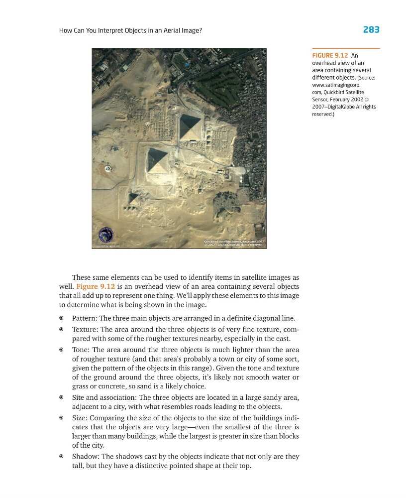
well. Figure 9.12 is an overhead view of an area containing several objects
that all add up to represent one thing. We’ll apply these elements to this image
to determine what is being shown in the image.
a Pattern: The three main objects are arranged in a definite diagonal line.
a Texture: The area around the three objects is of very fine texture, compared with some of the rougher textures nearby, especially in the east.
a Tone: The area around the three objects is much lighter than the area
of rougher texture (and that area’s probably a town or city of some sort,
given the pattern of the objects in this range). Given the tone and texture
of the ground around the three objects, it’s likely not smooth water or
grass or concrete, so sand is a likely choice.
a Site and association: The three objects are located in a large sandy area,
adjacent to a city, with what resembles roads leading to the objects.
a Size: Comparing the size of the objects to the size of the buildings indicates that the objects are very large—even the smallest of the three is
larger than many buildings, while the largest is greater in size than blocks
of the city.
a Shadow: The shadows cast by the objects indicate that not only are they
tall, but they have a distinctive pointed shape at their top.
FIGURE 9.12 An
overhead view of an
area containing several
different objects. (Source:
www.satimagingcorp.
com, Quickbird Satellite
Sensor, February 2002 ©
2007—DigitalGlobe All rights
reserved.)
How Can You Interpret Objects in an Aerial Image?
These same elements can be used to identify items in satellite images as
well. Figure 9.12 is an overhead view of an area containing several objects
that all add up to represent one thing. We’ll apply these elements to this image
to determine what is being shown in the image.
a Pattern: The three main objects are arranged in a definite diagonal line.
a Texture: The area around the three objects is of very fine texture, compared with some of the rougher textures nearby, especially in the east.
a Tone: The area around the three objects is much lighter than the area
of rougher texture (and that area’s probably a town or city of some sort,
given the pattern of the objects in this range). Given the tone and texture
of the ground around the three objects, it’s likely not smooth water or
grass or concrete, so sand is a likely choice.
a Site and association: The three objects are located in a large sandy area,
adjacent to a city, with what resembles roads leading to the objects.
a Size: Comparing the size of the objects to the size of the buildings indicates that the objects are very large—even the smallest of the three is
larger than many buildings, while the largest is greater in size than blocks
of the city.
a Shadow: The shadows cast by the objects indicate that not only are they
tall, but they have a distinctive pointed shape at their top.
FIGURE 9.12 An
overhead view of an
area containing several
different objects. (Source:
www.satimagingcorp.
com, Quickbird Satellite
Sensor, February 2002 ©
2007—DigitalGlobe All rights
reserved.)