

279
What Are the Different Types of Aerial Photos?
In an oblique photo, the camera is tilted so that it’s not positioned directly
at nadir, but rather at an angle. Take a look at Figure 9.2 again for an example
of this—the image of San Francisco taken from the kites. Unlike a vertical photo, you can see the sides of some of the buildings, and you’re really seeing the
city from a perspective view instead of an overhead one. Oblique images allow
for very different views of a target rather than from straight overhead and can
capture other types of information (such as the sides of buildings or mountains). Law enforcement agencies could make use of oblique photos of a building to obtain detailed information of all sides of a building (allowing a view of
entrances, exits, windows, and so on) before sending police into a potentially
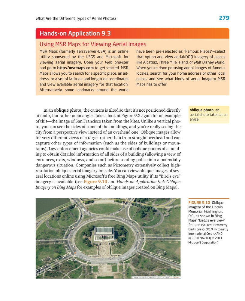
dangerous situation. Companies such as Pictometry extensively collect highresolution oblique aerial imagery for sale. You can view oblique images of several locations online using Microsoft’s free Bing Maps utility if its “Bird’s eye”
imagery is available (see Figure 9.10 and Hands-on Application 9.4: Oblique
Imagery on Bing Maps for examples of oblique images created on Bing Maps).
MSR Maps (formerly TerraServer-USA) is an online
utility sponsored by the USGS and Microsoft for
viewing aerial imagery. Open your Web browser
and go to http://msrmaps.com to get started. MSR
Maps allows you to search for a specific place, an address, or a set of latitude and longitude coordinates
and view available aerial imagery for that location.
Alternatively, some landmarks around the world
have been pre-selected as “Famous Places”—select
that option and view aerial/DOQ imagery of places
like Alcatraz, Three Mile Island, or Walt Disney World.
When you’re done perusing aerial images of famous
locales, search for your home address or other local
places and see what kinds of aerial imagery MSR
Maps has to offer.
Hands-on Application 9.3
Using MSR Maps for Viewing Aerial Images
oblique photo an
aerial photo taken at an
angle.
FIGURE 9.10 Oblique
imagery of the Lincoln
Memorial, Washington,
D.C., as shown in Bing
Maps’ “Birds’s eye view”
feature. (Source: Pictometry
Bird’s Eye © 2010 Pictometry
International Corp © AND
© 2010 NAVTEQ © 2011
Microsoft Corporation)
What Are the Different Types of Aerial Photos?
In an oblique photo, the camera is tilted so that it’s not positioned directly
at nadir, but rather at an angle. Take a look at Figure 9.2 again for an example
of this—the image of San Francisco taken from the kites. Unlike a vertical photo, you can see the sides of some of the buildings, and you’re really seeing the
city from a perspective view instead of an overhead one. Oblique images allow
for very different views of a target rather than from straight overhead and can
capture other types of information (such as the sides of buildings or mountains). Law enforcement agencies could make use of oblique photos of a building to obtain detailed information of all sides of a building (allowing a view of
entrances, exits, windows, and so on) before sending police into a potentially
dangerous situation. Companies such as Pictometry extensively collect highresolution oblique aerial imagery for sale. You can view oblique images of several locations online using Microsoft’s free Bing Maps utility if its “Bird’s eye”
imagery is available (see Figure 9.10 and Hands-on Application 9.4: Oblique
Imagery on Bing Maps for examples of oblique images created on Bing Maps).
MSR Maps (formerly TerraServer-USA) is an online
utility sponsored by the USGS and Microsoft for
viewing aerial imagery. Open your Web browser
and go to http://msrmaps.com to get started. MSR
Maps allows you to search for a specific place, an address, or a set of latitude and longitude coordinates
and view available aerial imagery for that location.
Alternatively, some landmarks around the world
have been pre-selected as “Famous Places”—select
that option and view aerial/DOQ imagery of places
like Alcatraz, Three Mile Island, or Walt Disney World.
When you’re done perusing aerial images of famous
locales, search for your home address or other local
places and see what kinds of aerial imagery MSR
Maps has to offer.
Hands-on Application 9.3
Using MSR Maps for Viewing Aerial Images
oblique photo an
aerial photo taken at an
angle.
FIGURE 9.10 Oblique
imagery of the Lincoln
Memorial, Washington,
D.C., as shown in Bing
Maps’ “Birds’s eye view”
feature. (Source: Pictometry
Bird’s Eye © 2010 Pictometry
International Corp © AND
© 2010 NAVTEQ © 2011
Microsoft Corporation)