

171
GIS Spatial Analysis: AEJEE Version
Question 6.7 How many cities are contained within the United States with
a population of more than 2,000,000 persons?
10. Clear all of the currently selected features and buffers.
6.6 More Spatial Analysis
1. The next analysis that you’ll perform involves analysis of the features
in relation to the five Great Lakes, so zoom in on the View so that you
can see all five Great Lakes. The first thing you’ll have to do is select the
Great Lakes to work with.
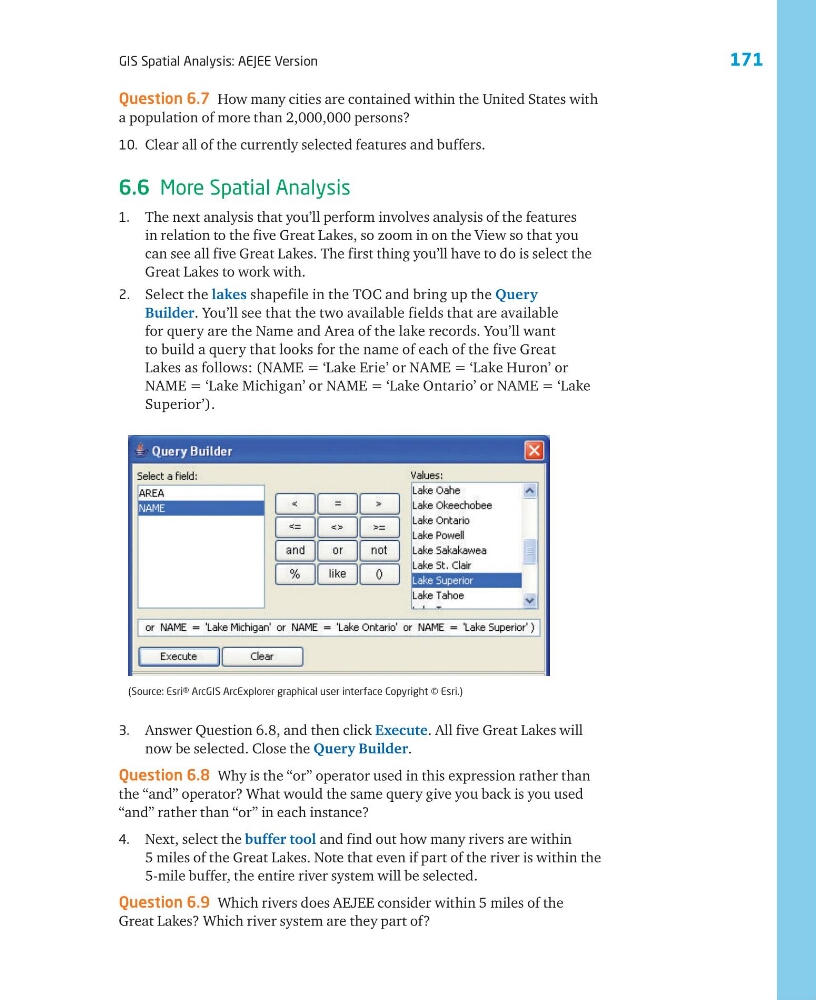
2. Select the lakes shapefile in the TOC and bring up the Query
Builder. You’ll see that the two available fields that are available
for query are the Name and Area of the lake records. You’ll want
to build a query that looks for the name of each of the five Great
Lakes as follows: (NAME = ‘Lake Erie’ or NAME = ‘Lake Huron’ or
NAME = ‘Lake Michigan’ or NAME = ‘Lake Ontario’ or NAME = ‘Lake
Superior’).
(Source: Esri® ArcGIS ArcExplorer graphical user interface Copyright © Esri.)
3. Answer Question 6.8, and then click Execute. All five Great Lakes will
now be selected. Close the Query Builder.
Question 6.8 Why is the “or” operator used in this expression rather than
the “and” operator? What would the same query give you back is you used
“and” rather than “or” in each instance?
4. Next, select the buffer tool and find out how many rivers are within
5 miles of the Great Lakes. Note that even if part of the river is within the
5-mile buffer, the entire river system will be selected.
Question 6.9 Which rivers does AEJEE consider within 5 miles of the
Great Lakes? Which river system are they part of?
GIS Spatial Analysis: AEJEE Version
Question 6.7 How many cities are contained within the United States with
a population of more than 2,000,000 persons?
10. Clear all of the currently selected features and buffers.
6.6 More Spatial Analysis
1. The next analysis that you’ll perform involves analysis of the features
in relation to the five Great Lakes, so zoom in on the View so that you
can see all five Great Lakes. The first thing you’ll have to do is select the
Great Lakes to work with.
2. Select the lakes shapefile in the TOC and bring up the Query
Builder. You’ll see that the two available fields that are available
for query are the Name and Area of the lake records. You’ll want
to build a query that looks for the name of each of the five Great
Lakes as follows: (NAME = ‘Lake Erie’ or NAME = ‘Lake Huron’ or
NAME = ‘Lake Michigan’ or NAME = ‘Lake Ontario’ or NAME = ‘Lake
Superior’).
(Source: Esri® ArcGIS ArcExplorer graphical user interface Copyright © Esri.)
3. Answer Question 6.8, and then click Execute. All five Great Lakes will
now be selected. Close the Query Builder.
Question 6.8 Why is the “or” operator used in this expression rather than
the “and” operator? What would the same query give you back is you used
“and” rather than “or” in each instance?
4. Next, select the buffer tool and find out how many rivers are within
5 miles of the Great Lakes. Note that even if part of the river is within the
5-mile buffer, the entire river system will be selected.
Question 6.9 Which rivers does AEJEE consider within 5 miles of the
Great Lakes? Which river system are they part of?