

84
Chapter 4 Finding Your Location with the Global Positioning System
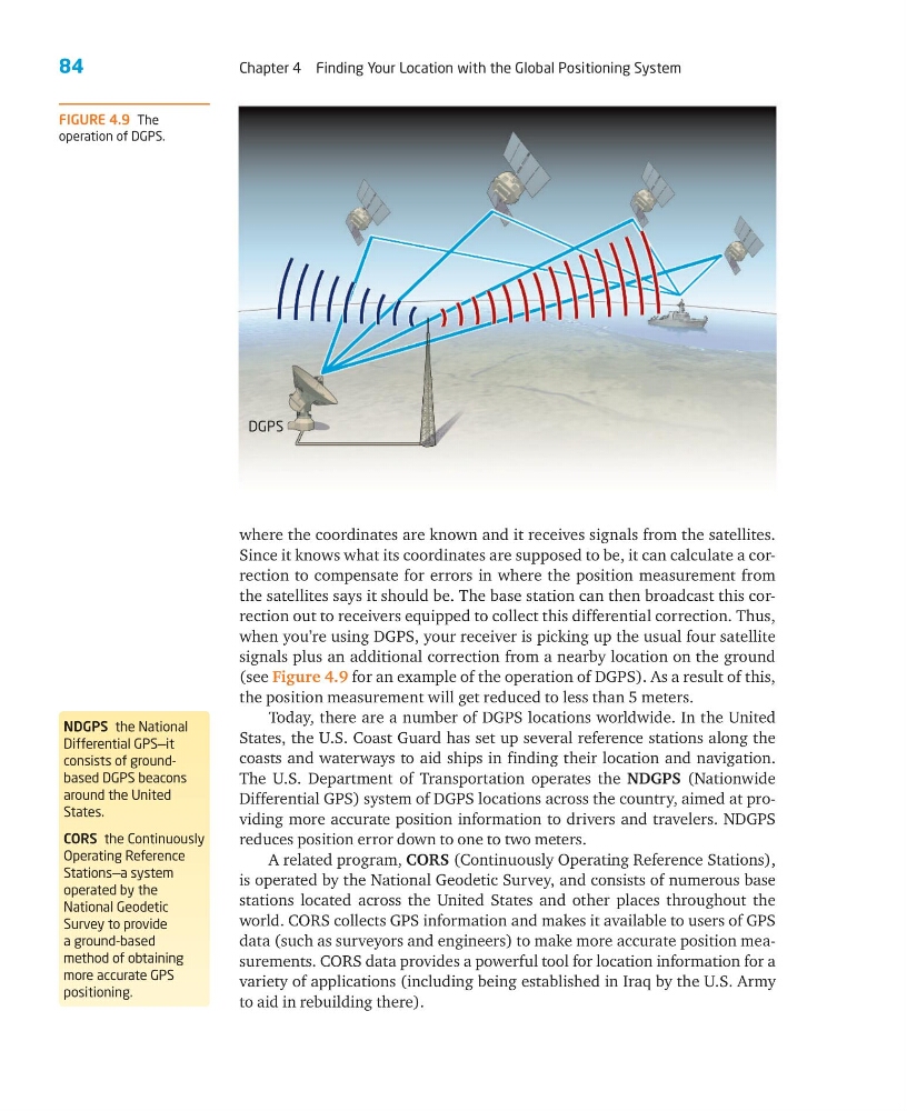
where the coordinates are known and it receives signals from the satellites.
Since it knows what its coordinates are supposed to be, it can calculate a correction to compensate for errors in where the position measurement from
the satellites says it should be. The base station can then broadcast this correction out to receivers equipped to collect this differential correction. Thus,
when you’re using DGPS, your receiver is picking up the usual four satellite
signals plus an additional correction from a nearby location on the ground
(see Figure 4.9 for an example of the operation of DGPS). As a result of this,
the position measurement will get reduced to less than 5 meters.
Today, there are a number of DGPS locations worldwide. In the United
States, the U.S. Coast Guard has set up several reference stations along the
coasts and waterways to aid ships in finding their location and navigation.
The U.S. Department of Transportation operates the NDGPS (Nationwide
Differential GPS) system of DGPS locations across the country, aimed at providing more accurate position information to drivers and travelers. NDGPS
reduces position error down to one to two meters.
A related program, CORS (Continuously Operating Reference Stations),
is operated by the National Geodetic Survey, and consists of numerous base
stations located across the United States and other places throughout the
world. CORS collects GPS information and makes it available to users of GPS
data (such as surveyors and engineers) to make more accurate position measurements. CORS data provides a powerful tool for location information for a
variety of applications (including being established in Iraq by the U.S. Army
to aid in rebuilding there).
NDGPS the National
Differential GPS—it
consists of groundbased DGPS beacons
around the United
States.
CORS the Continuously
Operating Reference
Stations—a system
operated by the
National Geodetic
Survey to provide
a ground-based
method of obtaining
more accurate GPS
positioning.
FIGURE 4.9 The
operation of DGPS.
DGPS
Chapter 4 Finding Your Location with the Global Positioning System
where the coordinates are known and it receives signals from the satellites.
Since it knows what its coordinates are supposed to be, it can calculate a correction to compensate for errors in where the position measurement from
the satellites says it should be. The base station can then broadcast this correction out to receivers equipped to collect this differential correction. Thus,
when you’re using DGPS, your receiver is picking up the usual four satellite
signals plus an additional correction from a nearby location on the ground
(see Figure 4.9 for an example of the operation of DGPS). As a result of this,
the position measurement will get reduced to less than 5 meters.
Today, there are a number of DGPS locations worldwide. In the United
States, the U.S. Coast Guard has set up several reference stations along the
coasts and waterways to aid ships in finding their location and navigation.
The U.S. Department of Transportation operates the NDGPS (Nationwide
Differential GPS) system of DGPS locations across the country, aimed at providing more accurate position information to drivers and travelers. NDGPS
reduces position error down to one to two meters.
A related program, CORS (Continuously Operating Reference Stations),
is operated by the National Geodetic Survey, and consists of numerous base
stations located across the United States and other places throughout the
world. CORS collects GPS information and makes it available to users of GPS
data (such as surveyors and engineers) to make more accurate position measurements. CORS data provides a powerful tool for location information for a
variety of applications (including being established in Iraq by the U.S. Army
to aid in rebuilding there).
NDGPS the National
Differential GPS—it
consists of groundbased DGPS beacons
around the United
States.
CORS the Continuously
Operating Reference
Stations—a system
operated by the
National Geodetic
Survey to provide
a ground-based
method of obtaining
more accurate GPS
positioning.
FIGURE 4.9 The
operation of DGPS.
DGPS