

impervious surfaces. The impervious surface has been emerging as a key indicator
of urbanization in recent years. The map of impervious surfaces may be useful in
revealing socioeconomic characteristics of a city. They found the impervious
surface was an effective variable in modeling residential population at all three
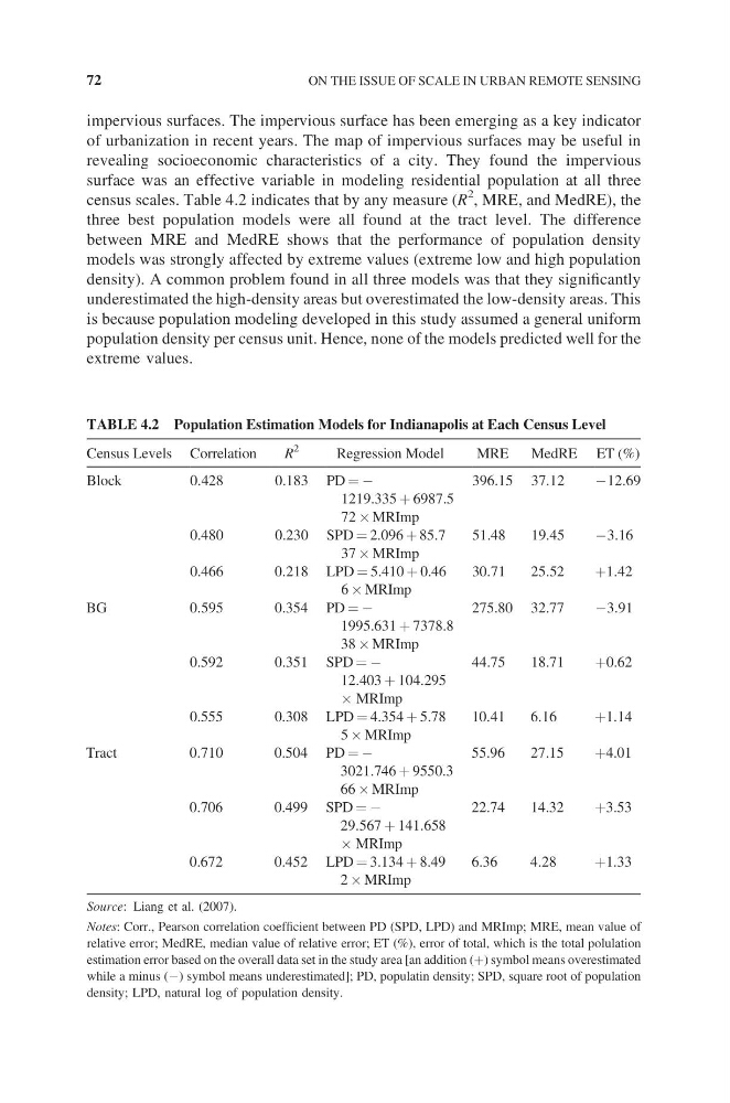
census scales. Table 4.2 indicates that by any measure (R
2 , MRE, and MedRE), the
three best population models were all found at the tract level. The difference
between MRE and MedRE shows that the performance of population density
models was strongly affected by extreme values (extreme low and high population
density). A common problem found in all three models was that they significantly
underestimated the high-density areas but overestimated the low-density areas. This
is because population modeling developed in this study assumed a general uniform
population density per census unit. Hence, none of the models predicted well for the
extreme values.
TABLE 4.2 Population Estimation Models for Indianapolis at Each Census Level
Census Levels Correlation
R
2
Regression Model
MRE
MedRE ET (%)
Block
0.428
0.183 PD = −
396.15 37.12
−12.69
1219.335 + 6987.5
72 ´ MRImp
0.480
0.230 SPD = 2.096 + 85.7
51.48
19.45
−3.16
37 ´ MRImp
0.466
0.218 LPD = 5.410 + 0.46
30.71
25.52
+1.42
6 ´ MRImp
BG
0.595
0.354 PD = −
275.80 32.77
−3.91
1995.631 + 7378.8
38 ´ MRImp
0.592
0.351 SPD = −
44.75
18.71
+0.62
12.403 + 104.295
´ MRImp
0.555
0.308 LPD = 4.354 + 5.78
10.41
6.16
+1.14
5 ´ MRImp
Tract
0.710
0.504 PD = −
55.96
27.15
+4.01
3021.746 + 9550.3
66 ´ MRImp
0.706
0.499 SPD = −
22.74
14.32
+3.53
29.567 + 141.658
´ MRImp
0.672
0.452 LPD = 3.134 + 8.49
6.36
4.28
+1.33
2 ´ MRImp
Source: Liang et al. (2007).
Notes: Corr., Pearson correlation coefficient between PD (SPD, LPD) and MRImp; MRE, mean value of
relative error; MedRE, median value of relative error; ET (%), error of total, which is the total polulation
estimation error based on the overall data set in the study area [an addition (+) symbol means overestimated
while a minus (−) symbol means underestimated]; PD, populatin density; SPD, square root of population
density; LPD, natural log of population density.
72
ON THE ISSUE OF SCALE IN URBAN REMOTE SENSING
of urbanization in recent years. The map of impervious surfaces may be useful in
revealing socioeconomic characteristics of a city. They found the impervious
surface was an effective variable in modeling residential population at all three
census scales. Table 4.2 indicates that by any measure (R
2 , MRE, and MedRE), the
three best population models were all found at the tract level. The difference
between MRE and MedRE shows that the performance of population density
models was strongly affected by extreme values (extreme low and high population
density). A common problem found in all three models was that they significantly
underestimated the high-density areas but overestimated the low-density areas. This
is because population modeling developed in this study assumed a general uniform
population density per census unit. Hence, none of the models predicted well for the
extreme values.
TABLE 4.2 Population Estimation Models for Indianapolis at Each Census Level
Census Levels Correlation
R
2
Regression Model
MRE
MedRE ET (%)
Block
0.428
0.183 PD = −
396.15 37.12
−12.69
1219.335 + 6987.5
72 ´ MRImp
0.480
0.230 SPD = 2.096 + 85.7
51.48
19.45
−3.16
37 ´ MRImp
0.466
0.218 LPD = 5.410 + 0.46
30.71
25.52
+1.42
6 ´ MRImp
BG
0.595
0.354 PD = −
275.80 32.77
−3.91
1995.631 + 7378.8
38 ´ MRImp
0.592
0.351 SPD = −
44.75
18.71
+0.62
12.403 + 104.295
´ MRImp
0.555
0.308 LPD = 4.354 + 5.78
10.41
6.16
+1.14
5 ´ MRImp
Tract
0.710
0.504 PD = −
55.96
27.15
+4.01
3021.746 + 9550.3
66 ´ MRImp
0.706
0.499 SPD = −
22.74
14.32
+3.53
29.567 + 141.658
´ MRImp
0.672
0.452 LPD = 3.134 + 8.49
6.36
4.28
+1.33
2 ´ MRImp
Source: Liang et al. (2007).
Notes: Corr., Pearson correlation coefficient between PD (SPD, LPD) and MRImp; MRE, mean value of
relative error; MedRE, median value of relative error; ET (%), error of total, which is the total polulation
estimation error based on the overall data set in the study area [an addition (+) symbol means overestimated
while a minus (−) symbol means underestimated]; PD, populatin density; SPD, square root of population
density; LPD, natural log of population density.
72
ON THE ISSUE OF SCALE IN URBAN REMOTE SENSING