

be mapped accurately with hyperspectral remote sensing techniques (Herold et al.,
2006). Therefore, land cover mapping requires taking into account the intraclass
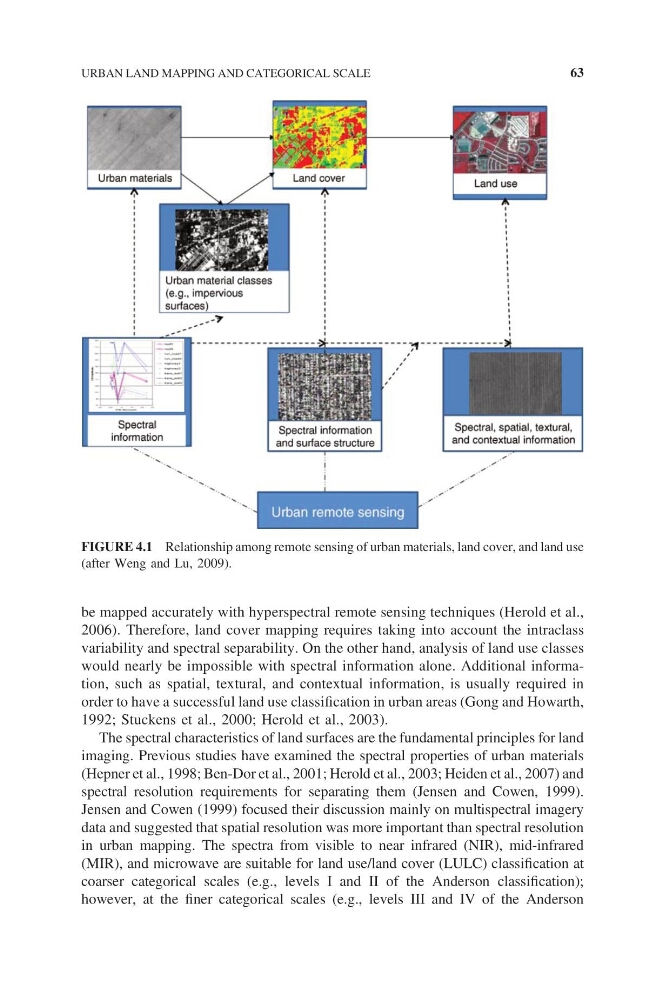
variability and spectral separability. On the other hand, analysis of land use classes
would nearly be impossible with spectral information alone. Additional information, such as spatial, textural, and contextual information, is usually required in
order to have a successful land use classification in urban areas (Gong and Howarth,
1992; Stuckens et al., 2000; Herold et al., 2003).
The spectral characteristics of land surfaces are the fundamental principles for land
imaging. Previous studies have examined the spectral properties of urban materials
(Hepner et al., 1998; Ben-Dor et al., 2001; Herold et al., 2003; Heiden et al., 2007) and
spectral resolution requirements for separating them (Jensen and Cowen, 1999).
Jensen and Cowen (1999) focused their discussion mainly on multispectral imagery
data and suggested that spatial resolution was more important than spectral resolution
in urban mapping. The spectra from visible to near infrared (NIR), mid-infrared
(MIR), and microwave are suitable for land use/land cover (LULC) classification at
coarser categorical scales (e.g., levels I and II of the Anderson classification);
however, at the finer categorical scales (e.g., levels III and IV of the Anderson
FIGURE 4.1 Relationship among remote sensing of urban materials, land cover, and land use
(after Weng and Lu, 2009).
URBAN LAND MAPPING AND CATEGORICAL SCALE
63
2006). Therefore, land cover mapping requires taking into account the intraclass
variability and spectral separability. On the other hand, analysis of land use classes
would nearly be impossible with spectral information alone. Additional information, such as spatial, textural, and contextual information, is usually required in
order to have a successful land use classification in urban areas (Gong and Howarth,
1992; Stuckens et al., 2000; Herold et al., 2003).
The spectral characteristics of land surfaces are the fundamental principles for land
imaging. Previous studies have examined the spectral properties of urban materials
(Hepner et al., 1998; Ben-Dor et al., 2001; Herold et al., 2003; Heiden et al., 2007) and
spectral resolution requirements for separating them (Jensen and Cowen, 1999).
Jensen and Cowen (1999) focused their discussion mainly on multispectral imagery
data and suggested that spatial resolution was more important than spectral resolution
in urban mapping. The spectra from visible to near infrared (NIR), mid-infrared
(MIR), and microwave are suitable for land use/land cover (LULC) classification at
coarser categorical scales (e.g., levels I and II of the Anderson classification);
however, at the finer categorical scales (e.g., levels III and IV of the Anderson
FIGURE 4.1 Relationship among remote sensing of urban materials, land cover, and land use
(after Weng and Lu, 2009).
URBAN LAND MAPPING AND CATEGORICAL SCALE
63