

good. The investigators note that METRIC offers promise for use in mapping regional
ET in the THP region.
In a study over the U.S. central Great Plains, Park et al. (2005) used surface
temperatures (T s ) derived from MODIS data for correlation with concurrent water
budget variables. Using a climate water budget program, four daily water budget
factors (percentage of soil moisture, actual/potential ET ratio, moisture deficit, and
moisture deficit potential ET ratio) were calculated at six weather station sites across
western and central Kansas. Correlation analysis showed that T s deviations from air
temperature had a significant relationship with water budget factors. To do the
analysis on a weekly basis, daily MODIS data were integrated into three different
types of weekly composites, including maximum T s driestday, and maximum T s
deviation from maximum air temperature, or max T a . Results showed that the
maximum T s deviation (T s –maxT a ) temperature composite had the largest correlation
with the climatic water budget parameters. Correlation for different data acquisition
times of MODIS TIR data improved the representativeness of signals for surface
moisture conditions. The driest-day composite was most sensitive to time correction.
After time correction, its relationship with soil moisture content improved by 11.1%
on average, but the degree of correlation improvement varied spatially, but there was
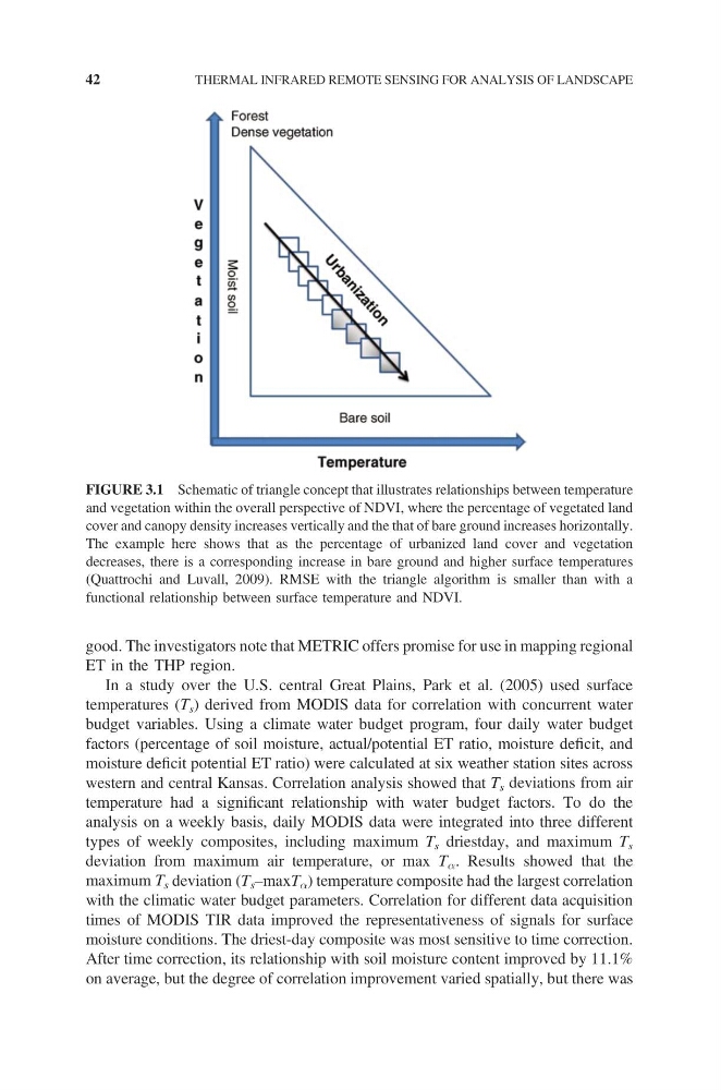
FIGURE 3.1 Schematic of triangle concept that illustrates relationships between temperature
and vegetation within the overall perspective of NDVI, where the percentage of vegetated land
cover and canopy density increases vertically and the that of bare ground increases horizontally.
The example here shows that as the percentage of urbanized land cover and vegetation
decreases, there is a corresponding increase in bare ground and higher surface temperatures
(Quattrochi and Luvall, 2009). RMSE with the triangle algorithm is smaller than with a
functional relationship between surface temperature and NDVI.
42
THERMAL INFRARED REMOTE SENSING FOR ANALYSIS OF LANDSCAPE
ET in the THP region.
In a study over the U.S. central Great Plains, Park et al. (2005) used surface
temperatures (T s ) derived from MODIS data for correlation with concurrent water
budget variables. Using a climate water budget program, four daily water budget
factors (percentage of soil moisture, actual/potential ET ratio, moisture deficit, and
moisture deficit potential ET ratio) were calculated at six weather station sites across
western and central Kansas. Correlation analysis showed that T s deviations from air
temperature had a significant relationship with water budget factors. To do the
analysis on a weekly basis, daily MODIS data were integrated into three different
types of weekly composites, including maximum T s driestday, and maximum T s
deviation from maximum air temperature, or max T a . Results showed that the
maximum T s deviation (T s –maxT a ) temperature composite had the largest correlation
with the climatic water budget parameters. Correlation for different data acquisition
times of MODIS TIR data improved the representativeness of signals for surface
moisture conditions. The driest-day composite was most sensitive to time correction.
After time correction, its relationship with soil moisture content improved by 11.1%
on average, but the degree of correlation improvement varied spatially, but there was
FIGURE 3.1 Schematic of triangle concept that illustrates relationships between temperature
and vegetation within the overall perspective of NDVI, where the percentage of vegetated land
cover and canopy density increases vertically and the that of bare ground increases horizontally.
The example here shows that as the percentage of urbanized land cover and vegetation
decreases, there is a corresponding increase in bare ground and higher surface temperatures
(Quattrochi and Luvall, 2009). RMSE with the triangle algorithm is smaller than with a
functional relationship between surface temperature and NDVI.
42
THERMAL INFRARED REMOTE SENSING FOR ANALYSIS OF LANDSCAPE