

Based on these evaluations, we conclude that radar images should at least have a
nominal scale ratio of 1 : 6 to provide a benefit for a SAR/multispectral EO fusion. For
instance, this means that TerraSAR-X data can be used to sharpen SPOT or even
Landsat TM image data but are of no or little use for improving the spatial resolution
of modern multispectral very high resolution (VHR) sensors. This is demonstrated in
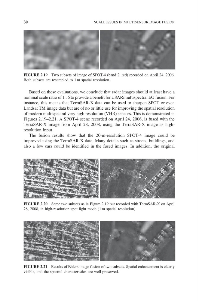
Figures 2.19–2.21. A SPOT-4 scene recorded on April 24, 2006, is fused with the
TerraSAR-X image from April 28, 2008, using the TerraSAR-X image as highresolution input.
The fusion results show that the 20-m-resolution SPOT-4 image could be
improved using the TerraSAR-X data. Many details such as streets, buildings, and
also a few cars could be identified in the fused images. In addition, the original
FIGURE 2.19 Two subsets of image of SPOT-4 (band 2, red) recorded on April 24, 2006.
Both subsets are resampled to 1 m spatial resolution.
FIGURE 2.20 Same two subsets as in Figure 2.19 but recorded with TerraSAR-X on April
28, 2008, in high-resolution spot light mode (1 m spatial resolution).
FIGURE 2.21 Results of Ehlers image fusion of two subsets. Spatial enhancement is clearly
visible, and the spectral characteristics are well preserved.
30
SCALE ISSUES IN MULTISENSOR IMAGE FUSION
nominal scale ratio of 1 : 6 to provide a benefit for a SAR/multispectral EO fusion. For
instance, this means that TerraSAR-X data can be used to sharpen SPOT or even
Landsat TM image data but are of no or little use for improving the spatial resolution
of modern multispectral very high resolution (VHR) sensors. This is demonstrated in
Figures 2.19–2.21. A SPOT-4 scene recorded on April 24, 2006, is fused with the
TerraSAR-X image from April 28, 2008, using the TerraSAR-X image as highresolution input.
The fusion results show that the 20-m-resolution SPOT-4 image could be
improved using the TerraSAR-X data. Many details such as streets, buildings, and
also a few cars could be identified in the fused images. In addition, the original
FIGURE 2.19 Two subsets of image of SPOT-4 (band 2, red) recorded on April 24, 2006.
Both subsets are resampled to 1 m spatial resolution.
FIGURE 2.20 Same two subsets as in Figure 2.19 but recorded with TerraSAR-X on April
28, 2008, in high-resolution spot light mode (1 m spatial resolution).
FIGURE 2.21 Results of Ehlers image fusion of two subsets. Spatial enhancement is clearly
visible, and the spectral characteristics are well preserved.
30
SCALE ISSUES IN MULTISENSOR IMAGE FUSION