

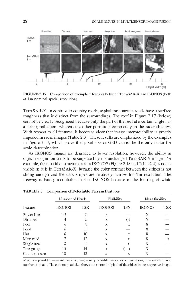
TerraSAR-X. In contrast to country roads, asphalt or concrete roads have a surface
roughness that is distinct from the surroundings. The roof in Figure 2.17 (below)
cannot be clearly recognized because only the part of the roof at a certain angle has
a strong reflection, whereas the other portion is completely in the radar shadow.
With respect to all features, it becomes clear that image interpretability is greatly
impeded in radar images (Table 2.3). These results are emphasized by the examples
in Figure 2.17, which prove that pixel size or GSD cannot be the only factor for
scale determination.
As IKONOS images are degraded to lower resolution, however, the ability in
object recognition starts to be surpassed by the unchanged TerraSAR-X image. For
example, the repetitive structure in 4-m IKONOS (Figure 2.18 and Table 2.4) is not as
visible as it is in TerraSAR-X, because the color contrast between the stripes is not
strong enough and the dark stripes are relatively narrow for 4 m resolution. The
freeway is barely identifiable in 4-m IKONOS because of the blurring of white
FIGURE 2.17 Comparison of exemplary features between TerraSAR-X and IKONOS (both
at 1 m nominal spatial resolution).
TABLE 2.3 Comparison of Detectable Terrain Features
Number of Pixels
Visibility
Identifiability
Feature
IKONOS
TSX
IKONOS
TSX
IKONOS
TSX
Power line
1-2
U
x
—
X
—
Dirt road
4
U
x
(-)
X
—
Pool
6
8
x
x
X
—
Pond
6
U
x
—
X
—
Hut
6
10
x
x
X
—
Main road
7
12
x
x
X
x
Single tree
8
U
x
x
X
—
Tree group
13
14
x
(—)
X
—
Country house
18
13
x
x
X
—
Note: x = possible, — = not possible, (—) = only possible under some conditions, U = undetermined
number of pixels. The column pixel size shows the amount of pixel of the object in the respective image.
28
SCALE ISSUES IN MULTISENSOR IMAGE FUSION
roughness that is distinct from the surroundings. The roof in Figure 2.17 (below)
cannot be clearly recognized because only the part of the roof at a certain angle has
a strong reflection, whereas the other portion is completely in the radar shadow.
With respect to all features, it becomes clear that image interpretability is greatly
impeded in radar images (Table 2.3). These results are emphasized by the examples
in Figure 2.17, which prove that pixel size or GSD cannot be the only factor for
scale determination.
As IKONOS images are degraded to lower resolution, however, the ability in
object recognition starts to be surpassed by the unchanged TerraSAR-X image. For
example, the repetitive structure in 4-m IKONOS (Figure 2.18 and Table 2.4) is not as
visible as it is in TerraSAR-X, because the color contrast between the stripes is not
strong enough and the dark stripes are relatively narrow for 4 m resolution. The
freeway is barely identifiable in 4-m IKONOS because of the blurring of white
FIGURE 2.17 Comparison of exemplary features between TerraSAR-X and IKONOS (both
at 1 m nominal spatial resolution).
TABLE 2.3 Comparison of Detectable Terrain Features
Number of Pixels
Visibility
Identifiability
Feature
IKONOS
TSX
IKONOS
TSX
IKONOS
TSX
Power line
1-2
U
x
—
X
—
Dirt road
4
U
x
(-)
X
—
Pool
6
8
x
x
X
—
Pond
6
U
x
—
X
—
Hut
6
10
x
x
X
—
Main road
7
12
x
x
X
x
Single tree
8
U
x
x
X
—
Tree group
13
14
x
(—)
X
—
Country house
18
13
x
x
X
—
Note: x = possible, — = not possible, (—) = only possible under some conditions, U = undetermined
number of pixels. The column pixel size shows the amount of pixel of the object in the respective image.
28
SCALE ISSUES IN MULTISENSOR IMAGE FUSION