

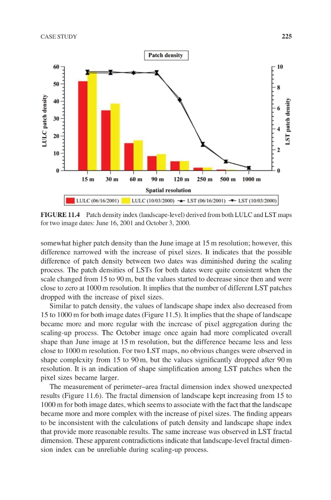
somewhat higher patch density than the June image at 15 m resolution; however, this
difference narrowed with the increase of pixel sizes. It indicates that the possible
difference of patch density between two dates was diminished during the scaling
process. The patch densities of LSTs for both dates were quite consistent when the
scale changed from 15 to 90 m, but the values started to decrease since then and were
close to zero at 1000 m resolution. It implies that the number of different LST patches
dropped with the increase of pixel sizes.
Similar to patch density, the values of landscape shape index also decreased from
15 to 1000 m for both image dates (Figure 11.5). It implies that the shape of landscape
became more and more regular with the increase of pixel aggregation during the
scaling-up process. The October image once again had more complicated overall
shape than June image at 15 m resolution, but the difference became less and less
close to 1000 m resolution. For two LST maps, no obvious changes were observed in
shape complexity from 15 to 90 m, but the values significantly dropped after 90 m
resolution. It is an indication of shape simplification among LST patches when the
pixel sizes became larger.
The measurement of perimeter–area fractal dimension index showed unexpected
results (Figure 11.6). The fractal dimension of landscape kept increasing from 15 to
1000 m for both image dates, which seems to associate with the fact that the landscape
became more and more complex with the increase of pixel sizes. The finding appears
to be inconsistent with the calculations of patch density and landscape shape index
that provide more reasonable results. The same increase was observed in LST fractal
dimension. These apparent contradictions indicate that landscape-level fractal dimension index can be unreliable during scaling-up process.
FIGURE 11.4 Patch density index (landscape-level) derived from both LULC and LST maps
for two image dates: June 16, 2001 and October 3, 2000.
CASE STUDY
225
difference narrowed with the increase of pixel sizes. It indicates that the possible
difference of patch density between two dates was diminished during the scaling
process. The patch densities of LSTs for both dates were quite consistent when the
scale changed from 15 to 90 m, but the values started to decrease since then and were
close to zero at 1000 m resolution. It implies that the number of different LST patches
dropped with the increase of pixel sizes.
Similar to patch density, the values of landscape shape index also decreased from
15 to 1000 m for both image dates (Figure 11.5). It implies that the shape of landscape
became more and more regular with the increase of pixel aggregation during the
scaling-up process. The October image once again had more complicated overall
shape than June image at 15 m resolution, but the difference became less and less
close to 1000 m resolution. For two LST maps, no obvious changes were observed in
shape complexity from 15 to 90 m, but the values significantly dropped after 90 m
resolution. It is an indication of shape simplification among LST patches when the
pixel sizes became larger.
The measurement of perimeter–area fractal dimension index showed unexpected
results (Figure 11.6). The fractal dimension of landscape kept increasing from 15 to
1000 m for both image dates, which seems to associate with the fact that the landscape
became more and more complex with the increase of pixel sizes. The finding appears
to be inconsistent with the calculations of patch density and landscape shape index
that provide more reasonable results. The same increase was observed in LST fractal
dimension. These apparent contradictions indicate that landscape-level fractal dimension index can be unreliable during scaling-up process.
FIGURE 11.4 Patch density index (landscape-level) derived from both LULC and LST maps
for two image dates: June 16, 2001 and October 3, 2000.
CASE STUDY
225