

262
Paul A. TYLER
Table 9.1
Characteristics of the main peripheral seas
Sea/sub region
Max depth (m)
Sill depth
Main characteristics
Area (km 2 )
Volume (km 3 )
Mediterranean
Warm: evaporation > fresh-water influx
2510×10 6
3771×10 6
West
3730
350 1
East
5093
400 2
Red Sea
>2000
200
Hot: evaporation fresh-water influx
0.45×10 6
0.251×10 6
Caribbean Sea
–
–
Warm: evaporation fresh-water influx
2.62×10 6
West
7600
1500 3
East
5400
2800/1815
Gulf of Mexico
3400
1500 3
Warm: evaporation fresh-water influx
1.543×10 6
2.322×10 6
Indonesian
archipelago
7000
2000
Warm: evaporation < fresh-water influx
Boundary not
distinct
Sea of Japan
4036
130
Cold: evaporation < fresh-water influx
1.01×10 6
1.36×10 6
Sea of Okhotsk
3657
2318
Cold: evaporation fresh-water influx
1.58×10 6
1.23×10 6
1 Strait of Gibraltar
2 Straits of Sicily
3 Strait of Yucatan
Golfe du
Lion
Catalan Sea
Alboran
Sea
G u lf o f
T a ra n to
Aegean
Sea
Crete
Cyprus
Rhodes
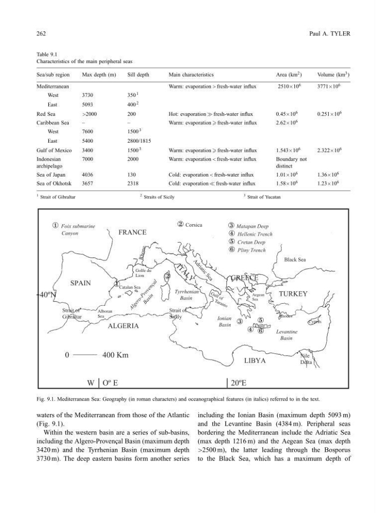
Fig. 9.1. Mediterranean Sea: Geography (in roman characters) and oceanographical features (in italics) referred to in the text.
waters of the Mediterranean from those of the Atlantic
(Fig. 9.1).
Within the western basin are a series of sub-basins,
including the Algero-Proven¸ cal Basin (maximum depth
3420 m) and the Tyrrhenian Basin (maximum depth
3730 m). The deep eastern basins form another series
including the Ionian Basin (maximum depth 5093 m)
and the Levantine Basin (4384 m). Peripheral seas
bordering the Mediterranean include the Adriatic Sea
(max depth 1216 m) and the Aegean Sea (max depth
>2500 m), the latter leading through the Bosporus
to the Black Sea, which has a maximum depth of
Paul A. TYLER
Table 9.1
Characteristics of the main peripheral seas
Sea/sub region
Max depth (m)
Sill depth
Main characteristics
Area (km 2 )
Volume (km 3 )
Mediterranean
Warm: evaporation > fresh-water influx
2510×10 6
3771×10 6
West
3730
350 1
East
5093
400 2
Red Sea
>2000
200
Hot: evaporation fresh-water influx
0.45×10 6
0.251×10 6
Caribbean Sea
–
–
Warm: evaporation fresh-water influx
2.62×10 6
West
7600
1500 3
East
5400
2800/1815
Gulf of Mexico
3400
1500 3
Warm: evaporation fresh-water influx
1.543×10 6
2.322×10 6
Indonesian
archipelago
7000
2000
Warm: evaporation < fresh-water influx
Boundary not
distinct
Sea of Japan
4036
130
Cold: evaporation < fresh-water influx
1.01×10 6
1.36×10 6
Sea of Okhotsk
3657
2318
Cold: evaporation fresh-water influx
1.58×10 6
1.23×10 6
1 Strait of Gibraltar
2 Straits of Sicily
3 Strait of Yucatan
Golfe du
Lion
Catalan Sea
Alboran
Sea
G u lf o f
T a ra n to
Aegean
Sea
Crete
Cyprus
Rhodes
Fig. 9.1. Mediterranean Sea: Geography (in roman characters) and oceanographical features (in italics) referred to in the text.
waters of the Mediterranean from those of the Atlantic
(Fig. 9.1).
Within the western basin are a series of sub-basins,
including the Algero-Proven¸ cal Basin (maximum depth
3420 m) and the Tyrrhenian Basin (maximum depth
3730 m). The deep eastern basins form another series
including the Ionian Basin (maximum depth 5093 m)
and the Levantine Basin (4384 m). Peripheral seas
bordering the Mediterranean include the Adriatic Sea
(max depth 1216 m) and the Aegean Sea (max depth
>2500 m), the latter leading through the Bosporus
to the Black Sea, which has a maximum depth of