

9
.
o
.
"
.
"
."
. ' ' -..-s
9
.
.
.
9
:
.----..:.:....,
9
.
.--,..
,,a=..&..i.~;.
~'...
'.
. ~
-
"..
. .
.
-:...
9 .
~
9 .~.
.
9
" "~
.
.
.
.
%
9 . 9 ,
9
...'~
...
.''....'-.
:!:.',.::..".,,,
9
'
~. " 9 ~"2""-.~'-:'.": "
"
.
"7. {.'-'" i' ~.~. ~'''?"
'
.'7"-- -'.--~.'.
"~.."
:: :": "~J~'"'~l~'"
.--...
. 9 ..~.
9
9
....
".'.'
9
~--, '.
:..::::!~.:.~:..~'.z,". "
9 <_ ~.:.~.. -.,: .: -...,~". ..: ,~:.~~
9
"
""'~"
"
."
..... ~
9 %:.'::x; " .... '"'"
9
-
-~. 9
. <...-.~ ...
:. . . . :~s. . _, , , ". "-". -~. -~-. . -_-. . '
-
~.
~
9
.
.
.,.
.
,
~o--~'-....s
..." :....:-:"~163
,
;
9
-.
9
.
~
.
.
-
9
~--~Z.~ 9 .~
'-~,
9
.
..
-~-..., ._,.:.j.. ~.~:..::
|
_
_
Q
US Highway 140
.
.. v
-
i::ii
=.~.
---~
!.
~ . . . .
.
d~"
9
.
.
Explanation
Q Shale and sandstone of Cretaceous G Piped gully
Mancos Shale
G Natural bridge
Q Tan silt and clay, sandy in places,
Quaternary
Q Cave
~ Flood plan of Aztec Wash
O Culvert
Aztec Wash low-flow channel
Q Gravity crack
Pipe system
system, piped
4~
.,..j
4~
c~
C~
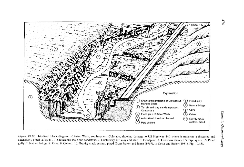
Figure 19.12. Idealized block diagram of Aztec Wash, southwestern Colorado, showing damage to US Highway 140 where it traverses a dissected and
extensively piped valley fill. 1. Cretaceous shale and sandstone. 2. Quaternary silt; clay and sand. 3. Floodplain. 4. Low-flow channel. 5. Pipe system. 6. Piped
gully. 7. Natural bridge. 8. Cave. 9. Culvert. 10. Gravity crack system, piped (from Parker and Jenne (1967), in Costa and Baker (1981), Fig. 10.15).
,,<
.
o
.
"
.
"
."
. ' ' -..-s
9
.
.
.
9
:
.----..:.:....,
9
.
.--,..
,,a=..&..i.~;.
~'...
'.
. ~
-
"..
. .
.
-:...
9 .
~
9 .~.
.
9
" "~
.
.
.
.
%
9 . 9 ,
9
...'~
...
.''....'-.
:!:.',.::..".,,,
9
'
~. " 9 ~"2""-.~'-:'.": "
"
.
"7. {.'-'" i' ~.~. ~'''?"
'
.'7"-- -'.--~.'.
"~.."
:: :": "~J~'"'~l~'"
.--...
. 9 ..~.
9
9
....
".'.'
9
~--, '.
:..::::!~.:.~:..~'.z,". "
9 <_ ~.:.~.. -.,: .: -...,~". ..: ,~:.~~
9
"
""'~"
"
."
..... ~
9 %:.'::x; " .... '"'"
9
-
-~. 9
. <...-.~ ...
:. . . . :~s. . _, , , ". "-". -~. -~-. . -_-. . '
-
~.
~
9
.
.
.,.
.
,
~o--~'-....s
..." :....:-:"~163
,
;
9
-.
9
.
~
.
.
-
9
~--~Z.~ 9 .~
'-~,
9
.
..
-~-..., ._,.:.j.. ~.~:..::
|
_
_
Q
US Highway 140
.
.. v
-
i::ii
=.~.
---~
!.
~ . . . .
.
d~"
9
.
.
Explanation
Q Shale and sandstone of Cretaceous G Piped gully
Mancos Shale
G Natural bridge
Q Tan silt and clay, sandy in places,
Quaternary
Q Cave
~ Flood plan of Aztec Wash
O Culvert
Aztec Wash low-flow channel
Q Gravity crack
Pipe system
system, piped
4~
.,..j
4~
c~
C~
Figure 19.12. Idealized block diagram of Aztec Wash, southwestern Colorado, showing damage to US Highway 140 where it traverses a dissected and
extensively piped valley fill. 1. Cretaceous shale and sandstone. 2. Quaternary silt; clay and sand. 3. Floodplain. 4. Low-flow channel. 5. Pipe system. 6. Piped
gully. 7. Natural bridge. 8. Cave. 9. Culvert. 10. Gravity crack system, piped (from Parker and Jenne (1967), in Costa and Baker (1981), Fig. 10.15).
,,<