

28
Climatic Geomorphology
Equator
d
1:,',1 Glacier zone
11111111111 Zone of pronounced valley
formation
~
Extratropical zone of valley
formation
Subtropical zone of pediment
l~\\\\'i
-
and valley formation
[L~~] Tropical zone of planation
surface formation
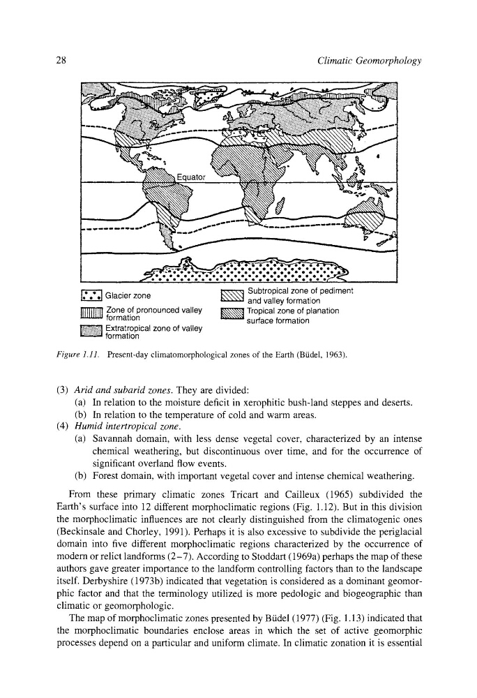
Figure 1.11. Present-day climatomorphological zones of the Earth (Btidel, 1963).
(3) Arid and subarid zones. They are divided:
(a) In relation to the moisture deficit in xerophitic bush-land steppes and deserts.
(b) In relation to the temperature of cold and warm areas.
(4) Humid intertropical zone.
(a) Savannah domain, with less dense vegetal cover, characterized by an intense
chemical weathering, but discontinuous over time, and for the occurrence of
significant overland flow events.
(b) Forest domain, with important vegetal cover and intense chemical weathering.
From these primary climatic zones Tricart and Cailleux (1965) subdivided the
Earth's surface into 12 different morphoclimatic regions (Fig. 1.12). But in this division
the morphoclimatic influences are not clearly distinguished from the climatogenic ones
(Beckinsale and Chorley, 1991). Perhaps it is also excessive to subdivide the periglacial
domain into five different morphoclimatic regions characterized by the occurrence of
modern or relict landforms (2-7). According to Stoddart (1969a) perhaps the map of these
authors gave greater importance to the landform controlling factors than to the landscape
itself. Derbyshire (1973b) indicated that vegetation is considered as a dominant geomorphic factor and that the terminology utilized is more pedologic and biogeographic than
climatic or geomorphologic.
The map of morphoclimatic zones presented by Btidel (1977) (Fig. 1.13) indicated that
the morphoclimatic boundaries enclose areas in which the set of active geomorphic
processes depend on a particular and uniform climate. In climatic zonation it is essential
Climatic Geomorphology
Equator
d
1:,',1 Glacier zone
11111111111 Zone of pronounced valley
formation
~
Extratropical zone of valley
formation
Subtropical zone of pediment
l~\\\\'i
-
and valley formation
[L~~] Tropical zone of planation
surface formation
Figure 1.11. Present-day climatomorphological zones of the Earth (Btidel, 1963).
(3) Arid and subarid zones. They are divided:
(a) In relation to the moisture deficit in xerophitic bush-land steppes and deserts.
(b) In relation to the temperature of cold and warm areas.
(4) Humid intertropical zone.
(a) Savannah domain, with less dense vegetal cover, characterized by an intense
chemical weathering, but discontinuous over time, and for the occurrence of
significant overland flow events.
(b) Forest domain, with important vegetal cover and intense chemical weathering.
From these primary climatic zones Tricart and Cailleux (1965) subdivided the
Earth's surface into 12 different morphoclimatic regions (Fig. 1.12). But in this division
the morphoclimatic influences are not clearly distinguished from the climatogenic ones
(Beckinsale and Chorley, 1991). Perhaps it is also excessive to subdivide the periglacial
domain into five different morphoclimatic regions characterized by the occurrence of
modern or relict landforms (2-7). According to Stoddart (1969a) perhaps the map of these
authors gave greater importance to the landform controlling factors than to the landscape
itself. Derbyshire (1973b) indicated that vegetation is considered as a dominant geomorphic factor and that the terminology utilized is more pedologic and biogeographic than
climatic or geomorphologic.
The map of morphoclimatic zones presented by Btidel (1977) (Fig. 1.13) indicated that
the morphoclimatic boundaries enclose areas in which the set of active geomorphic
processes depend on a particular and uniform climate. In climatic zonation it is essential