

346
Climatic Geomorphology
t. "a L L.~
(~+
,'~
~v
~.W" rr, r- ~ ~...:.
~
_....
_~
;~
~
P, , >~'~-'..
,-(~
o..
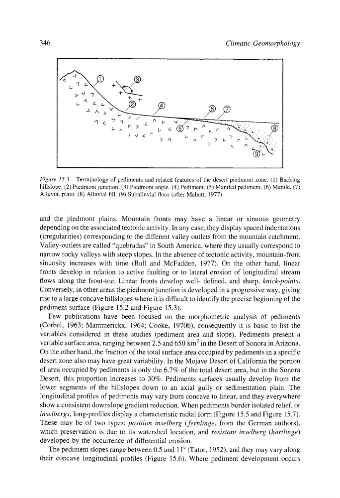
Figure 15.3. Terminology of pediments and related features of the desert piedmont zone. (1) Backing
hillslope. (2) Piedmont junction. (3) Piedmont angle. (4) Pediment. (5) Mantled pediment. (6) Mantle. (7)
Alluvial plain. (8) Alluvial fill. (9) Suballuvial floor (after Mabutt, 1977).
and the piedmont plains. Mountain fronts may have a linear or sinuous geometry
depending on the associated tectonic activity. In any case, they display spaced indentations
(irregularities) corresponding to the different valley outlets from the mountain catchment.
Valley-outlets are called "quebradas" in South America, where they usually correspond to
narrow rocky valleys with steep slopes. In the absence of tectonic activity, mountain-front
sinuosity increases with time (Bull and McFadden, 1977). On the other hand, linear
fronts develop in relation to active faulting or to lateral erosion of longitudinal stream
flows along the front-toe. Linear fronts develop well- defined, and sharp, knick-points.
Conversely, in other areas the piedmont junction is developed in a progressive way, giving
rise to a large concave hillslopes where it is difficult to identify the precise beginning of the
pediment surface (Figure 15.2 and Figure 15.3).
Few publications have been focused on the morphometric analysis of pediments
(Corbel, 1963; Mammerickx, 1964; Cooke, 1970b), consequently it is basic to list the
variables considered in these studies (pediment area and slope). Pediments present a
variable surface area, ranging between 2.5 and 650 km 2 in the Desert of Sonora in Arizona.
On the other hand, the fraction of the total surface area occupied by pediments in a specific
desert zone also may have great variability. In the Mojave Desert of California the portion
of area occupied by pediments is only the 6.7% of the total desert area, but in the Sonora
Desert, this proportion increases to 30%. Pediments surfaces usually develop from the
lower segments of the hillslopes down to an axial gully or sedimentation plain. The
longitudinal profiles of pediments may vary from concave to linear, and they everywhere
show a consistent downslope gradient reduction. When pediments border isolated relief, or
inselbergs, long-profiles display a characteristic radial form (Figure 15.5 and Figure 15.7).
These may be of two types: position inselberg (fernlinge, from the German authors),
which preservation is due to its watershed location, and resistant inselberg (hiirtlinge)
developed by the occurrence of differential erosion.
The pediment slopes range between 0.5 and 11 ~ (Tator, 1952), and they may vary along
their concave longitudinal profiles (Figure 15.6). Where pediment development occurs
Climatic Geomorphology
t. "a L L.~
(~+
,'~
~v
~.W" rr, r- ~ ~...:.
~
_....
_~
;~
~
P, , >~'~-'..
,-(~
o..
Figure 15.3. Terminology of pediments and related features of the desert piedmont zone. (1) Backing
hillslope. (2) Piedmont junction. (3) Piedmont angle. (4) Pediment. (5) Mantled pediment. (6) Mantle. (7)
Alluvial plain. (8) Alluvial fill. (9) Suballuvial floor (after Mabutt, 1977).
and the piedmont plains. Mountain fronts may have a linear or sinuous geometry
depending on the associated tectonic activity. In any case, they display spaced indentations
(irregularities) corresponding to the different valley outlets from the mountain catchment.
Valley-outlets are called "quebradas" in South America, where they usually correspond to
narrow rocky valleys with steep slopes. In the absence of tectonic activity, mountain-front
sinuosity increases with time (Bull and McFadden, 1977). On the other hand, linear
fronts develop in relation to active faulting or to lateral erosion of longitudinal stream
flows along the front-toe. Linear fronts develop well- defined, and sharp, knick-points.
Conversely, in other areas the piedmont junction is developed in a progressive way, giving
rise to a large concave hillslopes where it is difficult to identify the precise beginning of the
pediment surface (Figure 15.2 and Figure 15.3).
Few publications have been focused on the morphometric analysis of pediments
(Corbel, 1963; Mammerickx, 1964; Cooke, 1970b), consequently it is basic to list the
variables considered in these studies (pediment area and slope). Pediments present a
variable surface area, ranging between 2.5 and 650 km 2 in the Desert of Sonora in Arizona.
On the other hand, the fraction of the total surface area occupied by pediments in a specific
desert zone also may have great variability. In the Mojave Desert of California the portion
of area occupied by pediments is only the 6.7% of the total desert area, but in the Sonora
Desert, this proportion increases to 30%. Pediments surfaces usually develop from the
lower segments of the hillslopes down to an axial gully or sedimentation plain. The
longitudinal profiles of pediments may vary from concave to linear, and they everywhere
show a consistent downslope gradient reduction. When pediments border isolated relief, or
inselbergs, long-profiles display a characteristic radial form (Figure 15.5 and Figure 15.7).
These may be of two types: position inselberg (fernlinge, from the German authors),
which preservation is due to its watershed location, and resistant inselberg (hiirtlinge)
developed by the occurrence of differential erosion.
The pediment slopes range between 0.5 and 11 ~ (Tator, 1952), and they may vary along
their concave longitudinal profiles (Figure 15.6). Where pediment development occurs