

148
Climatic Geomorphology
(Figure 7.1). This differentiation is based upon the percentage of permafrost beneath a
certain point. The proportion of frozen ground in the continuous permafrost is higher than
80% between 30 and 80% in the discontinuous permafrost, and less than 30% in the
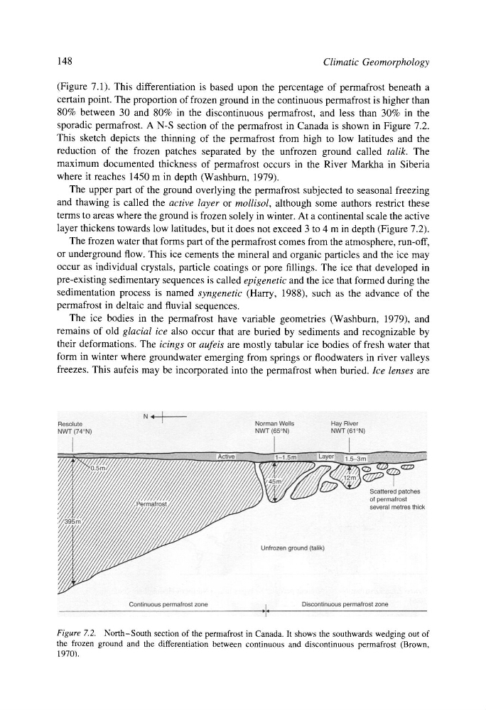
sporadic permafrost. A N-S section of the permafrost in Canada is shown in Figure 7.2.
This sketch depicts the thinning of the permafrost from high to low latitudes and the
reduction of the frozen patches separated by the unfrozen ground called talik. The
maximum documented thickness of permafrost occurs in the River Markha in Siberia
where it reaches 1450 m in depth (Washburn, 1979).
The upper part of the ground overlying the permafrost subjected to seasonal freezing
and thawing is called the active layer or mollisol, although some authors restrict these
terms to areas where the ground is frozen solely in winter. At a continental scale the active
layer thickens towards low latitudes, but it does not exceed 3 to 4 m in depth (Figure 7.2).
The frozen water that forms part of the permafrost comes from the atmosphere, run-off,
or underground flow. This ice cements the mineral and organic particles and the ice may
occur as individual crystals, particle coatings or pore fillings. The ice that developed in
pre-existing sedimentary sequences is called epigenetic and the ice that formed during the
sedimentation process is named syngenetic (Harry, 1988), such as the advance of the
permafrost in deltaic and fluvial sequences.
The ice bodies in the permafrost have variable geometries (Washburn, 1979), and
remains of old glacial ice also occur that are buffed by sediments and recognizable by
their deformations. The icings or aufeis are mostly tabular ice bodies of fresh water that
form in winter where groundwater emerging from springs or floodwaters in river valleys
freezes. This aufeis may be incorporated into the permafrost when buried. Ice lenses are
Figure 7.2. North-South section of the permafrost in Canada. It shows the southwards wedging out of
the frozen ground and the differentiation between continuous and discontinuous permafrost (Brown,
1970).
Climatic Geomorphology
(Figure 7.1). This differentiation is based upon the percentage of permafrost beneath a
certain point. The proportion of frozen ground in the continuous permafrost is higher than
80% between 30 and 80% in the discontinuous permafrost, and less than 30% in the
sporadic permafrost. A N-S section of the permafrost in Canada is shown in Figure 7.2.
This sketch depicts the thinning of the permafrost from high to low latitudes and the
reduction of the frozen patches separated by the unfrozen ground called talik. The
maximum documented thickness of permafrost occurs in the River Markha in Siberia
where it reaches 1450 m in depth (Washburn, 1979).
The upper part of the ground overlying the permafrost subjected to seasonal freezing
and thawing is called the active layer or mollisol, although some authors restrict these
terms to areas where the ground is frozen solely in winter. At a continental scale the active
layer thickens towards low latitudes, but it does not exceed 3 to 4 m in depth (Figure 7.2).
The frozen water that forms part of the permafrost comes from the atmosphere, run-off,
or underground flow. This ice cements the mineral and organic particles and the ice may
occur as individual crystals, particle coatings or pore fillings. The ice that developed in
pre-existing sedimentary sequences is called epigenetic and the ice that formed during the
sedimentation process is named syngenetic (Harry, 1988), such as the advance of the
permafrost in deltaic and fluvial sequences.
The ice bodies in the permafrost have variable geometries (Washburn, 1979), and
remains of old glacial ice also occur that are buffed by sediments and recognizable by
their deformations. The icings or aufeis are mostly tabular ice bodies of fresh water that
form in winter where groundwater emerging from springs or floodwaters in river valleys
freezes. This aufeis may be incorporated into the permafrost when buried. Ice lenses are
Figure 7.2. North-South section of the permafrost in Canada. It shows the southwards wedging out of
the frozen ground and the differentiation between continuous and discontinuous permafrost (Brown,
1970).