

136
Climatic Geomorphology
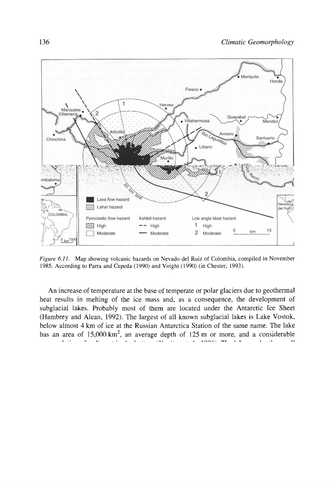
Figure 6.11. Map showing volcanic hazards on Nevado del Ruiz of Colombia, compiled in November
1985. According to Parra and Cepeda (1990) and Voight (1990) (in Chester, 1993).
An increase of temperature at the base of temperate or polar glaciers due to geothermal
heat results in melting of the ice mass and, as a consequence, the development of
subglacial lakes. Probably most of them are located under the Antarctic Ice Sheet
(Hambrey and Alean, 1992). The largest of all known subglacial lakes is Lake Vostok,
below almost 4 km of ice at the Russian Antarctica Station of the same name. The lake
has an area of 15,000 km 2, an average depth of 125 m or more, and a considerable
accumulation of sediment in the bottom (Kapitsa et al., 1996). The lakes under the small
Iceland ice sheets have a well-documented history of volcanic activity under the glacial
ice and their consequent floods. Ten percent of these ice sheets cover volcanically active
rift areas.
Near the middle of the Vatnaj6kull Ice Sheet, the Grfmsv6tn subglacial lake is located
in an active geothermal area where a number of eruptions have occurred in historical times
(Thorarinsson, 1953). When the lake breaks very large floods (j6kulhlaups) are triggered
on the Skeidarfirsandur plains (1000 km 2 with a gradient of 1/200) at the south end of
the ice sheet, thus building the greatest of Icelandic sandur. In past times an average
of 12 floods every 10 years has occurred, and the mean volume of each flood has been 3 to
3.5 km 3, with their maximum discharge being 10,000 m 3 s -~. Each j6kulhlaup has carried
about 30 million tons of sediment (Bjornsson, 1979). These floods can be triggered by an
increase of geothermal heat or by an eruption, like that of 1934, wherein the total sediment
Climatic Geomorphology
Figure 6.11. Map showing volcanic hazards on Nevado del Ruiz of Colombia, compiled in November
1985. According to Parra and Cepeda (1990) and Voight (1990) (in Chester, 1993).
An increase of temperature at the base of temperate or polar glaciers due to geothermal
heat results in melting of the ice mass and, as a consequence, the development of
subglacial lakes. Probably most of them are located under the Antarctic Ice Sheet
(Hambrey and Alean, 1992). The largest of all known subglacial lakes is Lake Vostok,
below almost 4 km of ice at the Russian Antarctica Station of the same name. The lake
has an area of 15,000 km 2, an average depth of 125 m or more, and a considerable
accumulation of sediment in the bottom (Kapitsa et al., 1996). The lakes under the small
Iceland ice sheets have a well-documented history of volcanic activity under the glacial
ice and their consequent floods. Ten percent of these ice sheets cover volcanically active
rift areas.
Near the middle of the Vatnaj6kull Ice Sheet, the Grfmsv6tn subglacial lake is located
in an active geothermal area where a number of eruptions have occurred in historical times
(Thorarinsson, 1953). When the lake breaks very large floods (j6kulhlaups) are triggered
on the Skeidarfirsandur plains (1000 km 2 with a gradient of 1/200) at the south end of
the ice sheet, thus building the greatest of Icelandic sandur. In past times an average
of 12 floods every 10 years has occurred, and the mean volume of each flood has been 3 to
3.5 km 3, with their maximum discharge being 10,000 m 3 s -~. Each j6kulhlaup has carried
about 30 million tons of sediment (Bjornsson, 1979). These floods can be triggered by an
increase of geothermal heat or by an eruption, like that of 1934, wherein the total sediment