

Fluvioglacial erosion and sedimentation
111
which every 10 years or so flash floods occur with discharges of about 40,000 to
50,000 m 3 s -1, flooding around 1000 km 2 of a sandy-gravel plain (sandur). Its normal
discharge is about 400 m 3 s -1 (Thorarinsson, 1953; Bj6rnsson, 1992).
In the geomorphic record, there are some outstanding extreme paleofloods in the
Pleistocene era, such as those recently discovered in the Altai Mountains of Siberia (Baker
et al., 1993), and those of Lake Missoula, in the northwestern United States (Bretz, 1923).
This latter is also known as the Spokane flood. In both cases, the peak discharges reached
several million cubic metres per second. The floods were triggered by advances of lobes of
the ice sheet lobes that blocked the drainages, and formed large ice-dammed lakes. When
the dam was destroyed by the ice dam floating upwards or being melted through, a sudden,
extreme flood occurred.
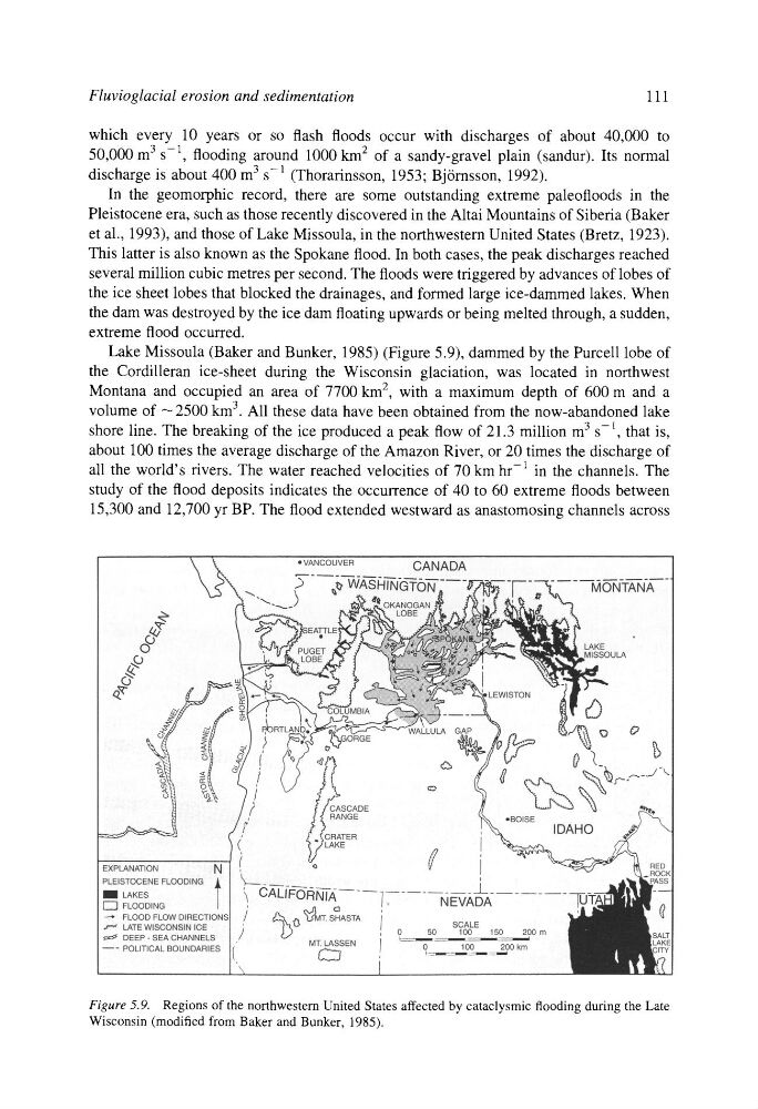
Lake Missoula (Baker and Bunker, 1985) (Figure 5.9), dammed by the Purcell lobe of
the Cordilleran ice-sheet during the Wisconsin glaciation, was located in northwest
Montana and occupied an area of 7700 km 2, with a maximum depth of 600 m and a
volume of ---2500 km 3. All these data have been obtained from the now-abandoned lake
shore line. The breaking of the ice produced a peak flow of 21.3 million m 3 s-l, that is,
about 100 times the average discharge of the Amazon River, or 20 times the discharge of
all the world's rivers. The water reached velocities of 70 km hr-1 in the channels. The
study of the flood deposits indicates the occurrence of 40 to 60 extreme floods between
15,300 and 12,700 yr BP. The flood extended westward as anastomosing channels across
Figure 5.9. Regions of the northwestern United States affected by cataclysmic flooding during the Late
Wisconsin (modified from Baker and Bunker, 1985).
111
which every 10 years or so flash floods occur with discharges of about 40,000 to
50,000 m 3 s -1, flooding around 1000 km 2 of a sandy-gravel plain (sandur). Its normal
discharge is about 400 m 3 s -1 (Thorarinsson, 1953; Bj6rnsson, 1992).
In the geomorphic record, there are some outstanding extreme paleofloods in the
Pleistocene era, such as those recently discovered in the Altai Mountains of Siberia (Baker
et al., 1993), and those of Lake Missoula, in the northwestern United States (Bretz, 1923).
This latter is also known as the Spokane flood. In both cases, the peak discharges reached
several million cubic metres per second. The floods were triggered by advances of lobes of
the ice sheet lobes that blocked the drainages, and formed large ice-dammed lakes. When
the dam was destroyed by the ice dam floating upwards or being melted through, a sudden,
extreme flood occurred.
Lake Missoula (Baker and Bunker, 1985) (Figure 5.9), dammed by the Purcell lobe of
the Cordilleran ice-sheet during the Wisconsin glaciation, was located in northwest
Montana and occupied an area of 7700 km 2, with a maximum depth of 600 m and a
volume of ---2500 km 3. All these data have been obtained from the now-abandoned lake
shore line. The breaking of the ice produced a peak flow of 21.3 million m 3 s-l, that is,
about 100 times the average discharge of the Amazon River, or 20 times the discharge of
all the world's rivers. The water reached velocities of 70 km hr-1 in the channels. The
study of the flood deposits indicates the occurrence of 40 to 60 extreme floods between
15,300 and 12,700 yr BP. The flood extended westward as anastomosing channels across
Figure 5.9. Regions of the northwestern United States affected by cataclysmic flooding during the Late
Wisconsin (modified from Baker and Bunker, 1985).