

North Latitude
Subsurface
CDOM Maxima
Colour contours: CDOM/QSU
Colour lines: Salinity/PSU
28.6
30
20
Depth/m
10
28.7
28.8
28.9
29.0
29.1
0
2
4
6
CDOMIQSU
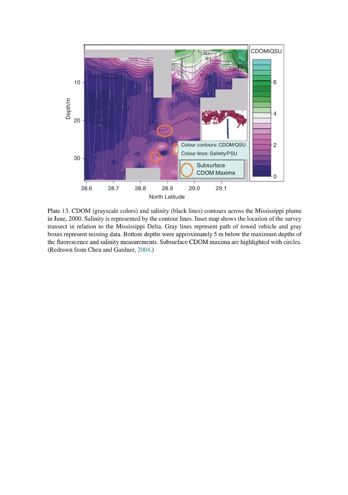
Plate 13. CDOM (grayscale colors) and salinity (black lines) contours across the Mississippi plume
in June, 2000. Salinity is represented by the contour lines. Inset map shows the location of the survey
transect in relation to the Mississippi Delta. Gray lines represent path of towed vehicle and gray
boxes represent missing data. Bottom depths were approximately 5 m below the maximum depths of
the fluorescence and salinity measurements. Subsurface CDOM maxima are highlighted with circles.
(Redrawn from Chen and Gardner, 2004.)
Subsurface
CDOM Maxima
Colour contours: CDOM/QSU
Colour lines: Salinity/PSU
28.6
30
20
Depth/m
10
28.7
28.8
28.9
29.0
29.1
0
2
4
6
CDOMIQSU
Plate 13. CDOM (grayscale colors) and salinity (black lines) contours across the Mississippi plume
in June, 2000. Salinity is represented by the contour lines. Inset map shows the location of the survey
transect in relation to the Mississippi Delta. Gray lines represent path of towed vehicle and gray
boxes represent missing data. Bottom depths were approximately 5 m below the maximum depths of
the fluorescence and salinity measurements. Subsurface CDOM maxima are highlighted with circles.
(Redrawn from Chen and Gardner, 2004.)