

10. EXPLOITATION AND EVALUATION OF RETRIEVAL
ALGORITHMS FOR GEOSTATIONARY SATELLITE DATA
PROCESSING
81
3.
POTENTIAL OF GEOSTATIONARY
OBSERVATIONS FOR LAND APPLICATIONS
Meteosat Second Generation (MSG) will have enhanced spectral
capabilities with respect to the present Meteosat satellite, in addition to an
improved image repeat cycle (15 minutes). The spectral characteristics of its
main radiometer, called Spinning Enhanced Visible and Infrared Imager
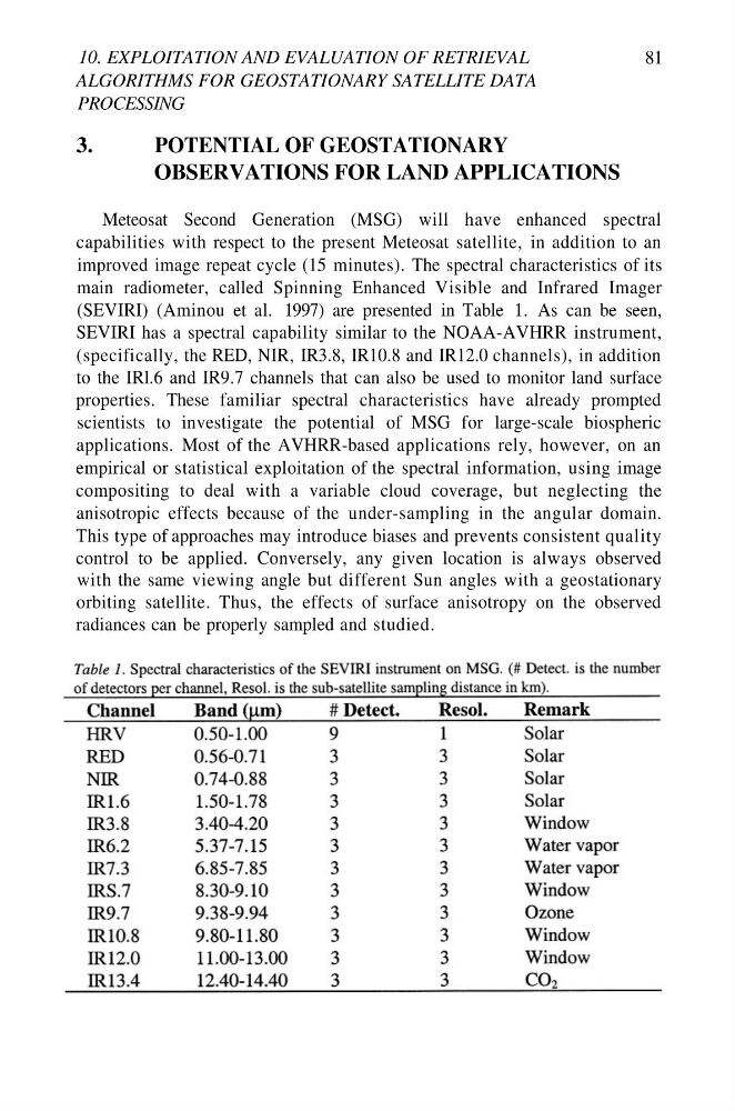
(SEVIRI) (Aminou et al. 1997) are presented in Table 1. As can be seen,
SEVIRI has a spectral capability similar to the NOAA-AVHRR instrument,
(specifically, the RED, NIR, IR3.8, IR10.8 and IR12.0 channels), in addition
to the IRl.6 and IR9.7 channels that can also be used to monitor land surface
properties. These familiar spectral characteristics have already prompted
scientists to investigate the potential of MSG for large-scale biospheric
applications. Most of the AVHRR-based applications rely, however, on an
empirical or statistical exploitation of the spectral information, using image
compositing to deal with a variable cloud coverage, but neglecting the
anisotropic effects because of the under-sampling in the angular domain.
This type of approaches may introduce biases and prevents consistent quality
control to be applied. Conversely, any given location is always observed
with the same viewing angle but different Sun angles with a geostationary
orbiting satellite. Thus, the effects of surface anisotropy on the observed
radiances can be properly sampled and studied.
ALGORITHMS FOR GEOSTATIONARY SATELLITE DATA
PROCESSING
81
3.
POTENTIAL OF GEOSTATIONARY
OBSERVATIONS FOR LAND APPLICATIONS
Meteosat Second Generation (MSG) will have enhanced spectral
capabilities with respect to the present Meteosat satellite, in addition to an
improved image repeat cycle (15 minutes). The spectral characteristics of its
main radiometer, called Spinning Enhanced Visible and Infrared Imager
(SEVIRI) (Aminou et al. 1997) are presented in Table 1. As can be seen,
SEVIRI has a spectral capability similar to the NOAA-AVHRR instrument,
(specifically, the RED, NIR, IR3.8, IR10.8 and IR12.0 channels), in addition
to the IRl.6 and IR9.7 channels that can also be used to monitor land surface
properties. These familiar spectral characteristics have already prompted
scientists to investigate the potential of MSG for large-scale biospheric
applications. Most of the AVHRR-based applications rely, however, on an
empirical or statistical exploitation of the spectral information, using image
compositing to deal with a variable cloud coverage, but neglecting the
anisotropic effects because of the under-sampling in the angular domain.
This type of approaches may introduce biases and prevents consistent quality
control to be applied. Conversely, any given location is always observed
with the same viewing angle but different Sun angles with a geostationary
orbiting satellite. Thus, the effects of surface anisotropy on the observed
radiances can be properly sampled and studied.