

294
Chapter 29
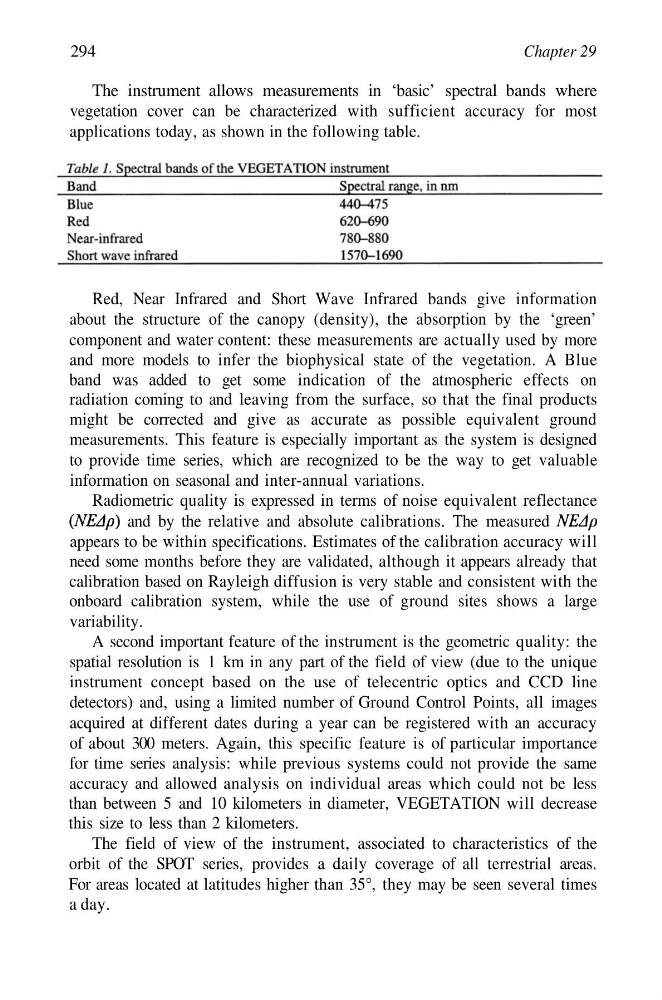
The instrument allows measurements in ‘basic’ spectral bands where
vegetation cover can be characterized with sufficient accuracy for most
applications today, as shown in the following table.
Red, Near Infrared and Short Wave Infrared bands give information
about the structure of the canopy (density), the absorption by the ‘green’
component and water content: these measurements are actually used by more
and more models to infer the biophysical state of the vegetation. A Blue
band was added to get some indication of the atmospheric effects on
radiation coming to and leaving from the surface, so that the final products
might be corrected and give as accurate as possible equivalent ground
measurements. This feature is especially important as the system is designed
to provide time series, which are recognized to be the way to get valuable
information on seasonal and inter-annual variations.
Radiometric quality is expressed in terms of noise equivalent reflectance
and by the relative and absolute calibrations. The measured
appears to be within specifications. Estimates of the calibration accuracy will
need some months before they are validated, although it appears already that
calibration based on Rayleigh diffusion is very stable and consistent with the
onboard calibration system, while the use of ground sites shows a large
variability.
A second important feature of the instrument is the geometric quality: the
spatial resolution is 1 km in any part of the field of view (due to the unique
instrument concept based on the use of telecentric optics and CCD line
detectors) and, using a limited number of Ground Control Points, all images
acquired at different dates during a year can be registered with an accuracy
of about 300 meters. Again, this specific feature is of particular importance
for time series analysis: while previous systems could not provide the same
accuracy and allowed analysis on individual areas which could not be less
than between 5 and 10 kilometers in diameter, VEGETATION will decrease
this size to less than 2 kilometers.
The field of view of the instrument, associated to characteristics of the
orbit of the SPOT series, provides a daily coverage of all terrestrial areas.
For areas located at latitudes higher than 35°, they may be seen several times
a day.
Chapter 29
The instrument allows measurements in ‘basic’ spectral bands where
vegetation cover can be characterized with sufficient accuracy for most
applications today, as shown in the following table.
Red, Near Infrared and Short Wave Infrared bands give information
about the structure of the canopy (density), the absorption by the ‘green’
component and water content: these measurements are actually used by more
and more models to infer the biophysical state of the vegetation. A Blue
band was added to get some indication of the atmospheric effects on
radiation coming to and leaving from the surface, so that the final products
might be corrected and give as accurate as possible equivalent ground
measurements. This feature is especially important as the system is designed
to provide time series, which are recognized to be the way to get valuable
information on seasonal and inter-annual variations.
Radiometric quality is expressed in terms of noise equivalent reflectance
and by the relative and absolute calibrations. The measured
appears to be within specifications. Estimates of the calibration accuracy will
need some months before they are validated, although it appears already that
calibration based on Rayleigh diffusion is very stable and consistent with the
onboard calibration system, while the use of ground sites shows a large
variability.
A second important feature of the instrument is the geometric quality: the
spatial resolution is 1 km in any part of the field of view (due to the unique
instrument concept based on the use of telecentric optics and CCD line
detectors) and, using a limited number of Ground Control Points, all images
acquired at different dates during a year can be registered with an accuracy
of about 300 meters. Again, this specific feature is of particular importance
for time series analysis: while previous systems could not provide the same
accuracy and allowed analysis on individual areas which could not be less
than between 5 and 10 kilometers in diameter, VEGETATION will decrease
this size to less than 2 kilometers.
The field of view of the instrument, associated to characteristics of the
orbit of the SPOT series, provides a daily coverage of all terrestrial areas.
For areas located at latitudes higher than 35°, they may be seen several times
a day.