

12. EARTH OBSERVATION DEMANDS FOR IMPROVED WATER
RESOURCES MANAGEMENT
111
use (e.g., Bastiaanssen et al., 1996). Dry matter accumulation is a direct
function of the cumulative amount of solar radiation and water transpired.
Remotely sensed estimates of leaf area index (e.g., Gobron et al., 1997),
photosynthetic active radiation (e.g., Asrar, 1992) and evapotranspiration
can therefore be very helpful in determining the productivity of water at the
regional scale, i.e., yield per unit of water consumed. Analysis and
management in a variety of ecosystems at the basin level can be assessed by
means of remote sensing techniques at a spatial level consistent with our
needs—observing with resolutions below 10 m, or truly basin level—is
feasible. The data can be collected at a variety of temporal resolutions, from
hours to weeks.
To the field researchers on irrigation, this combination of what can be
observed, and how it can be observed and interpreted is already a giant leap
from farmer interviews and staff gauge readings in irrigation canals.
Nevertheless, we see the potential for yet more, including the compilation of
objectively measured, remotely sensed data on irrigated river basins as the
basis for negotiation among competing sectors—and countries—for scarce
and valuable water resources.
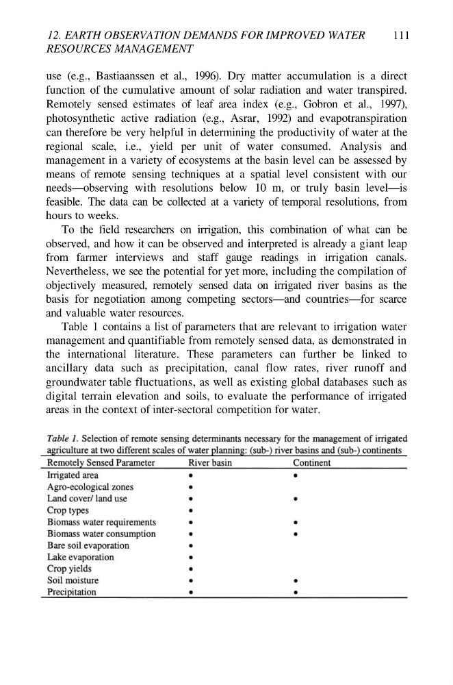
Table 1 contains a list of parameters that are relevant to irrigation water
management and quantifiable from remotely sensed data, as demonstrated in
the international literature. These parameters can further be linked to
ancillary data such as precipitation, canal flow rates, river runoff and
groundwater table fluctuations, as well as existing global databases such as
digital terrain elevation and soils, to evaluate the performance of irrigated
areas in the context of inter-sectoral competition for water.
RESOURCES MANAGEMENT
111
use (e.g., Bastiaanssen et al., 1996). Dry matter accumulation is a direct
function of the cumulative amount of solar radiation and water transpired.
Remotely sensed estimates of leaf area index (e.g., Gobron et al., 1997),
photosynthetic active radiation (e.g., Asrar, 1992) and evapotranspiration
can therefore be very helpful in determining the productivity of water at the
regional scale, i.e., yield per unit of water consumed. Analysis and
management in a variety of ecosystems at the basin level can be assessed by
means of remote sensing techniques at a spatial level consistent with our
needs—observing with resolutions below 10 m, or truly basin level—is
feasible. The data can be collected at a variety of temporal resolutions, from
hours to weeks.
To the field researchers on irrigation, this combination of what can be
observed, and how it can be observed and interpreted is already a giant leap
from farmer interviews and staff gauge readings in irrigation canals.
Nevertheless, we see the potential for yet more, including the compilation of
objectively measured, remotely sensed data on irrigated river basins as the
basis for negotiation among competing sectors—and countries—for scarce
and valuable water resources.
Table 1 contains a list of parameters that are relevant to irrigation water
management and quantifiable from remotely sensed data, as demonstrated in
the international literature. These parameters can further be linked to
ancillary data such as precipitation, canal flow rates, river runoff and
groundwater table fluctuations, as well as existing global databases such as
digital terrain elevation and soils, to evaluate the performance of irrigated
areas in the context of inter-sectoral competition for water.