

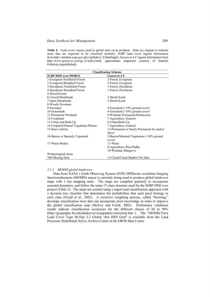
Table 2. Land cover classes used in global land cover products. Data are aligned to indicate
areas that are expected to be classified similarly. IGBP land cover legend information
from http://edcdaac.usgs.gov/glcc/globdoc2_0.html#app2, Geocover-LC legend information from
http://www.geocover.com/gc_lc/index.html; approximate alignment courtesy of Jennifer
Gebelein (unpublished).
Classification Scheme
IGBP DISCover/MOD12
Geocover-LC
1-Evergreen Needleleaf Forest
2-Forest, Evergreen
2-Evergreen Broadleaf Forest
2-Forest, Evergreen
3-Deciduous Needleleaf Forest
1-Forest, Deciduous
4-Deciduous Broadleaf Forest
1-Forest, Deciduous
5-Mixed Forest
6-Closed Shrublands
3-Shrub/Scrub
7-Open Shrublands
3-Shrub/Scrub
8-Woody Savannas
9-Savannas
4-Grassland (>10% ground cover)
10-Grasslands
4-Grassland (>10% ground cover)
11-Permanent Wetlands
9-Wetland, Permanent/Herbaceous
12-Croplands
7-Agriculture, General
13-Urban and Built-Up
6-Urban/Built-Up
14-Cropland/Natural Vegetation Mosaic
7-Agriculture, General
15-Snow and Ice
12-Permanent or Nearly Permanent Ice and/or
Snow
16-Barren or Sparsely Vegetated
5-Barren/Minimal Vegetation (<10% ground
cover)
17-Water Bodies
11-Water
8-Agriculture, Rice/Paddy
10-Wetland, Mangrove
99-Interrupted Areas
100-Missing Data
13-Cloud/Cloud Shadow/No Data
3.1.2 MODIS global landcover
Data from NASA’s Earth Observing System (EOS) MODerate resolution Imaging
Spectroradiometer (MODIS) sensor is currently being used to produce global landcover
maps with 1 km mapping units. The maps are compiled quarterly to incorporate
seasonal dynamics, and follow the same 17-class structure used for the IGBP DISCover
project (Table 2). The maps are created using a supervised classification approach with
a decision tree classifier that determines the probabilities that each pixel belongs to
each class (Friedl et al., 2002). A recursive weighting process, called “boosting,”
develops classification trees that can incorporate prior knowledge in order to improve
the global classification map (McIver and Friedl, 2002). Preliminary validation
results indicate classification accuracies for the different classes of 60 to 90%
(http://geography.bu.edu/landcover/userguidelc/consistent.htm ). The “MODIS/Terra
Land Cover Type 96-Day L3 Global 1km ISIN Grid” is available from the Land
Processes Distributed Active Archive Center at the EROS Data Center.
289
Data Synthesis for Management
areas that are expected to be classified similarly. IGBP land cover legend information
from http://edcdaac.usgs.gov/glcc/globdoc2_0.html#app2, Geocover-LC legend information from
http://www.geocover.com/gc_lc/index.html; approximate alignment courtesy of Jennifer
Gebelein (unpublished).
Classification Scheme
IGBP DISCover/MOD12
Geocover-LC
1-Evergreen Needleleaf Forest
2-Forest, Evergreen
2-Evergreen Broadleaf Forest
2-Forest, Evergreen
3-Deciduous Needleleaf Forest
1-Forest, Deciduous
4-Deciduous Broadleaf Forest
1-Forest, Deciduous
5-Mixed Forest
6-Closed Shrublands
3-Shrub/Scrub
7-Open Shrublands
3-Shrub/Scrub
8-Woody Savannas
9-Savannas
4-Grassland (>10% ground cover)
10-Grasslands
4-Grassland (>10% ground cover)
11-Permanent Wetlands
9-Wetland, Permanent/Herbaceous
12-Croplands
7-Agriculture, General
13-Urban and Built-Up
6-Urban/Built-Up
14-Cropland/Natural Vegetation Mosaic
7-Agriculture, General
15-Snow and Ice
12-Permanent or Nearly Permanent Ice and/or
Snow
16-Barren or Sparsely Vegetated
5-Barren/Minimal Vegetation (<10% ground
cover)
17-Water Bodies
11-Water
8-Agriculture, Rice/Paddy
10-Wetland, Mangrove
99-Interrupted Areas
100-Missing Data
13-Cloud/Cloud Shadow/No Data
3.1.2 MODIS global landcover
Data from NASA’s Earth Observing System (EOS) MODerate resolution Imaging
Spectroradiometer (MODIS) sensor is currently being used to produce global landcover
maps with 1 km mapping units. The maps are compiled quarterly to incorporate
seasonal dynamics, and follow the same 17-class structure used for the IGBP DISCover
project (Table 2). The maps are created using a supervised classification approach with
a decision tree classifier that determines the probabilities that each pixel belongs to
each class (Friedl et al., 2002). A recursive weighting process, called “boosting,”
develops classification trees that can incorporate prior knowledge in order to improve
the global classification map (McIver and Friedl, 2002). Preliminary validation
results indicate classification accuracies for the different classes of 60 to 90%
(http://geography.bu.edu/landcover/userguidelc/consistent.htm ). The “MODIS/Terra
Land Cover Type 96-Day L3 Global 1km ISIN Grid” is available from the Land
Processes Distributed Active Archive Center at the EROS Data Center.
289
Data Synthesis for Management