

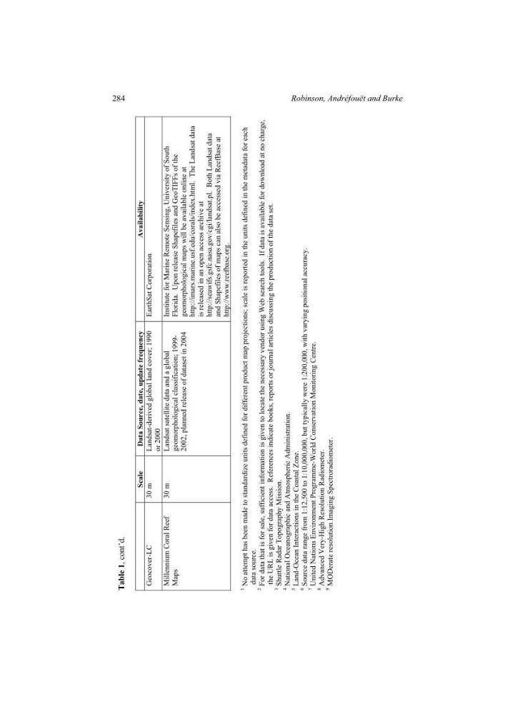
Table 1,
cont’d.
Scale Data Source, date, update frequency
Availability
Geocover-LC 30 m Landsat-derived global land cover; 1990
or 2000
EarthSat Corporation
Millennium Coral Reef
Maps
30 m Landsat satellite data and a global
geomorphological classification; 19992002, planned release of dataset in 2004
Institute for Marine Remote Sensing, University of South
Florida. Upon release Shapefiles and GeoTIFFs of the
geomorphological maps will be available online at http://imars.marine.usf.edu/corals/index.html. The Landsat data
is released in an open access archive at http://seawifs.gsfc.nasa.gov/cgi/landsat.pl. Both Landsat data
and Shapefiles of maps can also be accessed via ReefBase at
http://www.reefbase.org.
1
No attempt has been made to standardize units defined for different product
map projections; scale is reported in the units defined
in the metadata for each
data source.
2
For data that is for sale, sufficient information is given to locate the necessary
vendor using Web search tools. If data is
available for download at no charge,
the URL is given for data access. References indicate books,
reports or journal articles discussing the production of the data
set.
3
Shuttle Radar Topography Mission.
4
National Oceanographic and Atmospheric Administration.
5
Land-Ocean Interactions in the Coastal Zone.
6
Source data range from 1:12,500 to 1:10,000,000,
but typically were 1:200,000, with varying
positional accuracy.
7
United Nations Environment Programme-World Conservation Monitoring
Centre.
8
Advanced Very-High Resolution Radiometer.
9
MODerate resolution Imaging Spectroradiometer.
284
Robinson, Andréfouët and Burke
cont’d.
Scale Data Source, date, update frequency
Availability
Geocover-LC 30 m Landsat-derived global land cover; 1990
or 2000
EarthSat Corporation
Millennium Coral Reef
Maps
30 m Landsat satellite data and a global
geomorphological classification; 19992002, planned release of dataset in 2004
Institute for Marine Remote Sensing, University of South
Florida. Upon release Shapefiles and GeoTIFFs of the
geomorphological maps will be available online at http://imars.marine.usf.edu/corals/index.html. The Landsat data
is released in an open access archive at http://seawifs.gsfc.nasa.gov/cgi/landsat.pl. Both Landsat data
and Shapefiles of maps can also be accessed via ReefBase at
http://www.reefbase.org.
1
No attempt has been made to standardize units defined for different product
map projections; scale is reported in the units defined
in the metadata for each
data source.
2
For data that is for sale, sufficient information is given to locate the necessary
vendor using Web search tools. If data is
available for download at no charge,
the URL is given for data access. References indicate books,
reports or journal articles discussing the production of the data
set.
3
Shuttle Radar Topography Mission.
4
National Oceanographic and Atmospheric Administration.
5
Land-Ocean Interactions in the Coastal Zone.
6
Source data range from 1:12,500 to 1:10,000,000,
but typically were 1:200,000, with varying
positional accuracy.
7
United Nations Environment Programme-World Conservation Monitoring
Centre.
8
Advanced Very-High Resolution Radiometer.
9
MODerate resolution Imaging Spectroradiometer.
284
Robinson, Andréfouët and Burke