

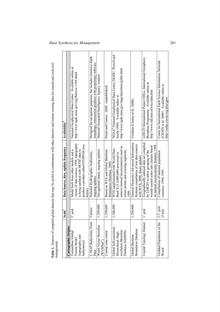
Table 1.
Sources of compiled global datasets that may be useful in combination with
other datasets and remote sensing data for coastal
and coral reef
management.
Scale
1
Data Source, date, update frequency Availability
2
Cartographic Origins
TerrainBase Global
Terrain Model
(topography and
bathymetry)
5’ grid Model built from other models and a
variety of data sources, 1994, topography
is being updated with SRTM
3
data to
produce a product called GTOPO30 (see
below).
National Geophysical Data Center. Available online at http://www.ngdc.noaa.gov/seg/fliers/se-1104.shtml
C-MAP Bathymetry Point
Data
Various National Hydrographic Authorities,
ongoing updates
Designed for navigation purposes, but includes extensive depth
soundings, commercial products with proprietary software
World Vector Shoreline
(WVSPlus
®
)
1:250,000 Navigational charts, ongoing updates National Geospatial-Intelligence Agency vendors
Coastal zone extent 1:250,000 Based on WVS and Global
Maritime
Boundaries Database, 2000
Pruett and Cimino. 2000. (unpublished)
Global Self-consistent,
Hierarchical, Highresolution Shoreline
Database (GSHHS)
1:100,000 WVS supplemented with World Data
Bank II (1:3,000,000) processed to
remove internal inconsistencies such as
erratic points and crossing segments,
1999
NOAA
4
National Geophysical Data Center (NGDC; Wessel and
Smith 1996). Available online at http://www.ngdc.noaa.gov/mgg/shorelines/gshhs.html
Global Maritime
Boundaries Database
1:250,000 General Dynamics Advanced Information
Systems compilation of text data sources
with WVS, 2000, future updates
Veridian (Cimino et al., 2000).
Coastal Typology Dataset 1’ grid Geographically indexed data
set compiled
by LOICZ5 to allow grouping of the
worlds coastal zones into clusters based
on natural socioeconomic features; 1998
LOICZ5 International Project Office, International Geosphere- Biosphere Programme. Available online at http://www.old.nioz.nl/loicz/data.htm
Gridded Population of the
World
2.5’ grid
(5 km)
Compilations of national population
censuses; 1990, 1995
Center for International Earth Science Information Network (CIESIN et al. 2000
). Available online at http://sedac.ciesin.org/plue/gpw
281
Data Synthesis for Management
Sources of compiled global datasets that may be useful in combination with
other datasets and remote sensing data for coastal
and coral reef
management.
Scale
1
Data Source, date, update frequency Availability
2
Cartographic Origins
TerrainBase Global
Terrain Model
(topography and
bathymetry)
5’ grid Model built from other models and a
variety of data sources, 1994, topography
is being updated with SRTM
3
data to
produce a product called GTOPO30 (see
below).
National Geophysical Data Center. Available online at http://www.ngdc.noaa.gov/seg/fliers/se-1104.shtml
C-MAP Bathymetry Point
Data
Various National Hydrographic Authorities,
ongoing updates
Designed for navigation purposes, but includes extensive depth
soundings, commercial products with proprietary software
World Vector Shoreline
(WVSPlus
®
)
1:250,000 Navigational charts, ongoing updates National Geospatial-Intelligence Agency vendors
Coastal zone extent 1:250,000 Based on WVS and Global
Maritime
Boundaries Database, 2000
Pruett and Cimino. 2000. (unpublished)
Global Self-consistent,
Hierarchical, Highresolution Shoreline
Database (GSHHS)
1:100,000 WVS supplemented with World Data
Bank II (1:3,000,000) processed to
remove internal inconsistencies such as
erratic points and crossing segments,
1999
NOAA
4
National Geophysical Data Center (NGDC; Wessel and
Smith 1996). Available online at http://www.ngdc.noaa.gov/mgg/shorelines/gshhs.html
Global Maritime
Boundaries Database
1:250,000 General Dynamics Advanced Information
Systems compilation of text data sources
with WVS, 2000, future updates
Veridian (Cimino et al., 2000).
Coastal Typology Dataset 1’ grid Geographically indexed data
set compiled
by LOICZ5 to allow grouping of the
worlds coastal zones into clusters based
on natural socioeconomic features; 1998
LOICZ5 International Project Office, International Geosphere- Biosphere Programme. Available online at http://www.old.nioz.nl/loicz/data.htm
Gridded Population of the
World
2.5’ grid
(5 km)
Compilations of national population
censuses; 1990, 1995
Center for International Earth Science Information Network (CIESIN et al. 2000
). Available online at http://sedac.ciesin.org/plue/gpw
281
Data Synthesis for Management