

4.4 PASSIVE MICROWAVE SENSORS AND SCATTEROMETERS
As is the case with the sensors listed in Table 3, sensors listed in Table 4 operate in
the microwave band of the electromagnetic spectrum, thus are not restricted by clouds
and can operate day and night. Note that sensors listed in Table 4 have spatial
resolutions on the order of kilometers whereas Tables 1 through 3 list spatial resolution
in meters.
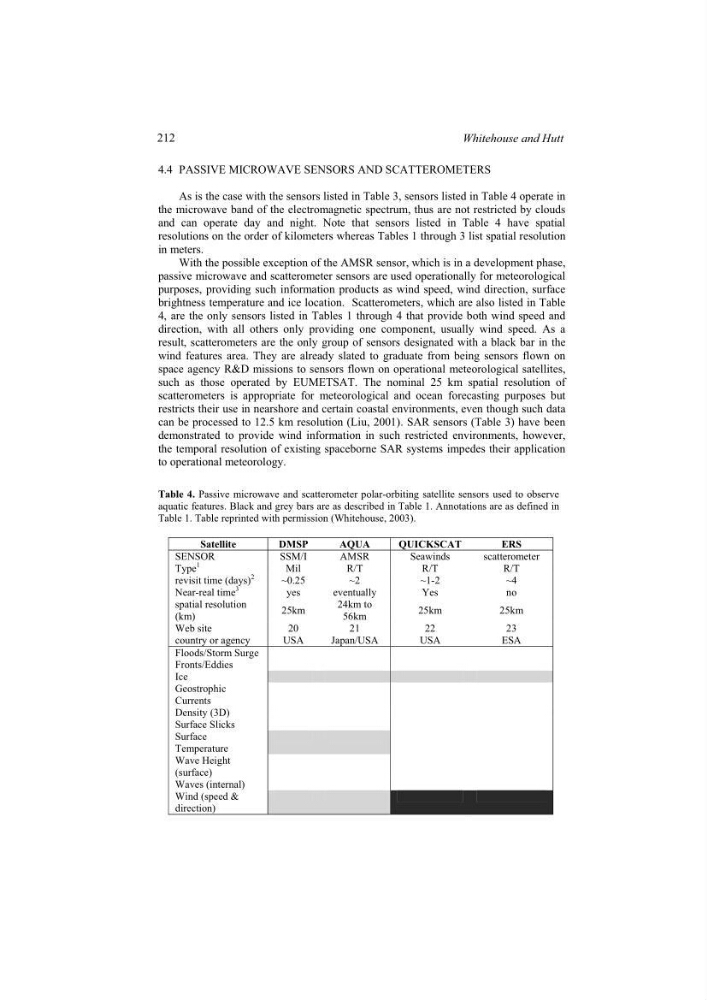
With the possible exception of the AMSR sensor, which is in a development phase,
passive microwave and scatterometer sensors are used operationally for meteorological
purposes, providing such information products as wind speed, wind direction, surface
brightness temperature and ice location. Scatterometers, which are also listed in Table
4, are the only sensors listed in Tables 1 through 4 that provide both wind speed and
direction, with all others only providing one component, usually wind speed. As a
result, scatterometers are the only group of sensors designated with a black bar in the
wind features area. They are already slated to graduate from being sensors flown on
space agency R&D missions to sensors flown on operational meteorological satellites,
such as those operated by EUMETSAT. The nominal 25 km spatial resolution of
scatterometers is appropriate for meteorological and ocean forecasting purposes but
restricts their use in nearshore and certain coastal environments, even though such data
can be processed to 12.5 km resolution (Liu, 2001). SAR sensors (Table 3) have been
demonstrated to provide wind information in such restricted environments, however,
the temporal resolution of existing spaceborne SAR systems impedes their application
to operational meteorology.
Table 4. Passive microwave and scatterometer polar-orbiting satellite sensors used to observe
aquatic features. Black and grey bars are as described in Table 1. Annotations are as defined in
Table 1. Table reprinted with permission (Whitehouse, 2003).
Satellite
DMSP
AQUA
QUICKSCAT
ERS
SENSOR
SSM/I
AMSR
Seawinds
scatterometer
Type
1
Mil
R/T
R/T
R/T
revisit time (days)
2
~0.25
~2
~1-2
~4
Near-real time
3
yes
eventually
Yes
no
spatial resolution
(km)
25km
24km to
56km
25km
25km
Web site
20
21
22
23
country or agency
USA
Japan/USA
USA
ESA
Floods/Storm Surge
Fronts/Eddies
Ice
Geostrophic
Currents
Density (3D)
Surface Slicks
Surface
Temperature
Wave Height
(surface)
Waves (internal)
Wind (speed &
direction)
212
Whitehouse and Hutt
As is the case with the sensors listed in Table 3, sensors listed in Table 4 operate in
the microwave band of the electromagnetic spectrum, thus are not restricted by clouds
and can operate day and night. Note that sensors listed in Table 4 have spatial
resolutions on the order of kilometers whereas Tables 1 through 3 list spatial resolution
in meters.
With the possible exception of the AMSR sensor, which is in a development phase,
passive microwave and scatterometer sensors are used operationally for meteorological
purposes, providing such information products as wind speed, wind direction, surface
brightness temperature and ice location. Scatterometers, which are also listed in Table
4, are the only sensors listed in Tables 1 through 4 that provide both wind speed and
direction, with all others only providing one component, usually wind speed. As a
result, scatterometers are the only group of sensors designated with a black bar in the
wind features area. They are already slated to graduate from being sensors flown on
space agency R&D missions to sensors flown on operational meteorological satellites,
such as those operated by EUMETSAT. The nominal 25 km spatial resolution of
scatterometers is appropriate for meteorological and ocean forecasting purposes but
restricts their use in nearshore and certain coastal environments, even though such data
can be processed to 12.5 km resolution (Liu, 2001). SAR sensors (Table 3) have been
demonstrated to provide wind information in such restricted environments, however,
the temporal resolution of existing spaceborne SAR systems impedes their application
to operational meteorology.
Table 4. Passive microwave and scatterometer polar-orbiting satellite sensors used to observe
aquatic features. Black and grey bars are as described in Table 1. Annotations are as defined in
Table 1. Table reprinted with permission (Whitehouse, 2003).
Satellite
DMSP
AQUA
QUICKSCAT
ERS
SENSOR
SSM/I
AMSR
Seawinds
scatterometer
Type
1
Mil
R/T
R/T
R/T
revisit time (days)
2
~0.25
~2
~1-2
~4
Near-real time
3
yes
eventually
Yes
no
spatial resolution
(km)
25km
24km to
56km
25km
25km
Web site
20
21
22
23
country or agency
USA
Japan/USA
USA
ESA
Floods/Storm Surge
Fronts/Eddies
Ice
Geostrophic
Currents
Density (3D)
Surface Slicks
Surface
Temperature
Wave Height
(surface)
Waves (internal)
Wind (speed &
direction)
212
Whitehouse and Hutt