

All of the multispectral satellite sensors listed in Table 1a are well known for their
terrestrial mapping applications. SPOT, for example, was used extensively during the
Gulf War in 1991. While they are not optimal sensors for observing aquatic
constituents, each of these land-oriented multispectral sensors have proven to be useful
in aquatic coastal projects involving tropical and subtropical waters, where the water is
relatively clear. With spatial resolutions ranging from submetre to a few tens of metres,
they usually meet the spatial resolution requirements of nearshore mapping programs. It
is almost certain that if not for the cost of purchasing large numbers of images produced
by these sensors, they would be used to a much greater extent by coastal managers and
researchers.
NASA’s Coastal Zone Color Scanner (CZCS), which was launched in 1978 and
produced data for the period 1979 to 1986, forever changed the way we view the
world’s oceans, and subsequently encouraged the development and eventual launch of
the marine-oriented multispectral sensors listed in Table 1B. Unfortunately, although
the follow-on to the CZCS mission, SeaWiFS, is still in operation, it was launched in
1997, thereby leaving a more than ten year temporal gap in ocean color data. The more
recent sensors listed in Table 1B, such as Modis and Meris, have additional spectral
bands which improve our ability to distinguish various coloring constituents which may
be present in coastal waters, such as constituents of terrestrial or benthic origin. Certain
multispectral programs, such as Modis, also include thermal IR sensors which permit
concurrent measurement of sea-surface temperature.
4.2 THERMAL IR SENSORS
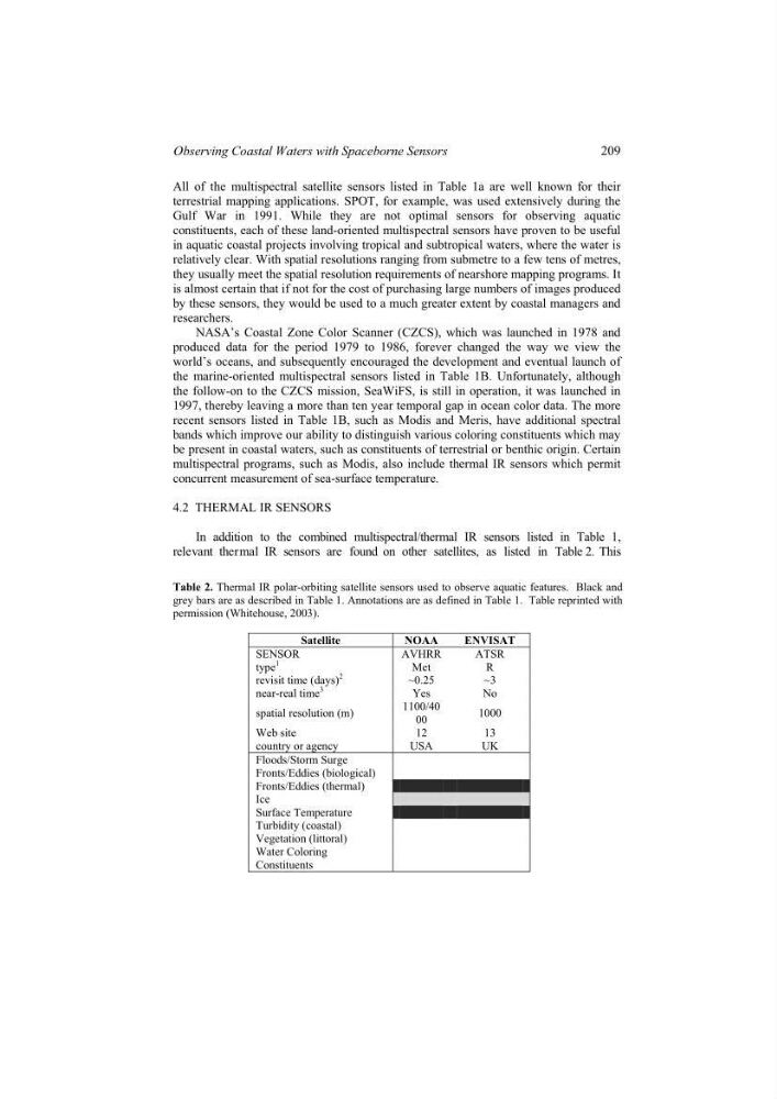
In addition to the combined multispectral/thermal IR sensors listed in Table 1,
Table 2. Thermal IR polar-orbiting satellite sensors used to observe aquatic features. Black and
grey bars are as described in Table 1. Annotations are as defined in Table 1. Table reprinted with
permission (Whitehouse, 2003).
Satellite
NOAA
ENVISAT
SENSOR
AVHRR
ATSR
type
1
Met
R
revisit time (days)
2
~0.25
~3
near-real time
3
Yes
No
spatial resolution (m)
1100/40
00
1000
Web site
12
13
country or agency
USA
UK
Floods/Storm Surge
Fronts/Eddies (biological)
Fronts/Eddies (thermal)
Ice
Surface Temperature
Turbidity (coastal)
Vegetation (littoral)
Water Coloring
Constituents
relevant thermal IR sensors are found on other satellites, as listed in Table 2. This
209
Observing Coastal Waters with Spaceborne Sensors
terrestrial mapping applications. SPOT, for example, was used extensively during the
Gulf War in 1991. While they are not optimal sensors for observing aquatic
constituents, each of these land-oriented multispectral sensors have proven to be useful
in aquatic coastal projects involving tropical and subtropical waters, where the water is
relatively clear. With spatial resolutions ranging from submetre to a few tens of metres,
they usually meet the spatial resolution requirements of nearshore mapping programs. It
is almost certain that if not for the cost of purchasing large numbers of images produced
by these sensors, they would be used to a much greater extent by coastal managers and
researchers.
NASA’s Coastal Zone Color Scanner (CZCS), which was launched in 1978 and
produced data for the period 1979 to 1986, forever changed the way we view the
world’s oceans, and subsequently encouraged the development and eventual launch of
the marine-oriented multispectral sensors listed in Table 1B. Unfortunately, although
the follow-on to the CZCS mission, SeaWiFS, is still in operation, it was launched in
1997, thereby leaving a more than ten year temporal gap in ocean color data. The more
recent sensors listed in Table 1B, such as Modis and Meris, have additional spectral
bands which improve our ability to distinguish various coloring constituents which may
be present in coastal waters, such as constituents of terrestrial or benthic origin. Certain
multispectral programs, such as Modis, also include thermal IR sensors which permit
concurrent measurement of sea-surface temperature.
4.2 THERMAL IR SENSORS
In addition to the combined multispectral/thermal IR sensors listed in Table 1,
Table 2. Thermal IR polar-orbiting satellite sensors used to observe aquatic features. Black and
grey bars are as described in Table 1. Annotations are as defined in Table 1. Table reprinted with
permission (Whitehouse, 2003).
Satellite
NOAA
ENVISAT
SENSOR
AVHRR
ATSR
type
1
Met
R
revisit time (days)
2
~0.25
~3
near-real time
3
Yes
No
spatial resolution (m)
1100/40
00
1000
Web site
12
13
country or agency
USA
UK
Floods/Storm Surge
Fronts/Eddies (biological)
Fronts/Eddies (thermal)
Ice
Surface Temperature
Turbidity (coastal)
Vegetation (littoral)
Water Coloring
Constituents
relevant thermal IR sensors are found on other satellites, as listed in Table 2. This
209
Observing Coastal Waters with Spaceborne Sensors