

satellite’s orbit repeat cycle. In other cases, the satellite sensor is steerable, or has a
wide swath (covers a wide area), or there are several satellites flying the same type of
sensor at a given time (i.e. a constellation), or some combination thereof. In such cases,
we refer to the satellite sensor’s effective revisit time. In general, the effective revisit
time of such a sensor will be shorter than the satellite’s orbit repeat cycle. The Canadian
Radarsat satellite, for example, orbits the planet every 100.7 minutes, completes 14
orbits per day, and repeats its orbit cycle every 24 days. However, Radarsat’s sensor,
which has various scanning and wide-swath modes, is capable of imaging a specific
geographic area every three to five days at mid latitudes, and approximately daily at
extremely high latitudes (e.g. polar regions). Thus, although Radarsat has an orbit
revisit cycle of 24 days, its effective revisit time is much faster, ranging between one to
several days.
The satellite sensor’s effective revisit time is the critical time element for
operational coastal management and science applications, as this is the element which
tells a manager or researcher how often the sensor will image a specific area of interest.
Engineering details, such as how long the satellite requires to orbit the planet or how
many orbits it completes per day, are not required for purposes of practical application.
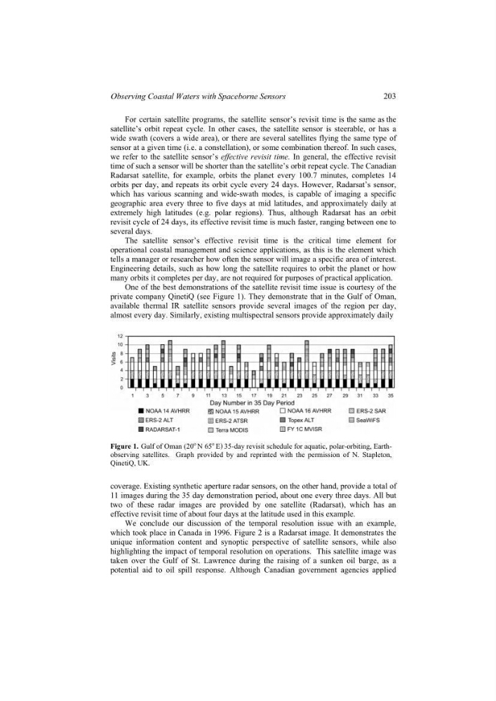
One of the best demonstrations of the satellite revisit time issue is courtesy of the
private company QinetiQ (see Figure 1). They demonstrate that in the Gulf of Oman,
available thermal IR satellite sensors provide several images of the region per day,
almost every day. Similarly, existing multispectral sensors provide approximately daily
Figure 1. Gulf of Oman (20
o N 65
o E) 35-day revisit schedule for aquatic, polar-orbiting, Earthobserving satellites. Graph provided by and reprinted with the permission of N. Stapleton,
QinetiQ, UK.
coverage. Existing synthetic aperture radar sensors, on the other hand, provide a total of
11 images during the 35 day demonstration period, about one every three days. All but
two of these radar images are provided by one satellite (Radarsat), which has an
effective revisit time of about four days at the latitude used in this example.
We conclude our discussion of the temporal resolution issue with an example,
which took place in Canada in 1996. Figure 2 is a Radarsat image. It demonstrates the
unique information content and synoptic perspective of satellite sensors, while also
highlighting the impact of temporal resolution on operations. This satellite image was
taken over the Gulf of St. Lawrence during the raising of a sunken oil barge, as a
potential aid to oil spill response. Although Canadian government agencies applied
For certain satellite programs, the satellite sensor revisit time is the same as the
’s
203
Observing Coastal Waters with Spaceborne Sensors
wide swath (covers a wide area), or there are several satellites flying the same type of
sensor at a given time (i.e. a constellation), or some combination thereof. In such cases,
we refer to the satellite sensor’s effective revisit time. In general, the effective revisit
time of such a sensor will be shorter than the satellite’s orbit repeat cycle. The Canadian
Radarsat satellite, for example, orbits the planet every 100.7 minutes, completes 14
orbits per day, and repeats its orbit cycle every 24 days. However, Radarsat’s sensor,
which has various scanning and wide-swath modes, is capable of imaging a specific
geographic area every three to five days at mid latitudes, and approximately daily at
extremely high latitudes (e.g. polar regions). Thus, although Radarsat has an orbit
revisit cycle of 24 days, its effective revisit time is much faster, ranging between one to
several days.
The satellite sensor’s effective revisit time is the critical time element for
operational coastal management and science applications, as this is the element which
tells a manager or researcher how often the sensor will image a specific area of interest.
Engineering details, such as how long the satellite requires to orbit the planet or how
many orbits it completes per day, are not required for purposes of practical application.
One of the best demonstrations of the satellite revisit time issue is courtesy of the
private company QinetiQ (see Figure 1). They demonstrate that in the Gulf of Oman,
available thermal IR satellite sensors provide several images of the region per day,
almost every day. Similarly, existing multispectral sensors provide approximately daily
Figure 1. Gulf of Oman (20
o N 65
o E) 35-day revisit schedule for aquatic, polar-orbiting, Earthobserving satellites. Graph provided by and reprinted with the permission of N. Stapleton,
QinetiQ, UK.
coverage. Existing synthetic aperture radar sensors, on the other hand, provide a total of
11 images during the 35 day demonstration period, about one every three days. All but
two of these radar images are provided by one satellite (Radarsat), which has an
effective revisit time of about four days at the latitude used in this example.
We conclude our discussion of the temporal resolution issue with an example,
which took place in Canada in 1996. Figure 2 is a Radarsat image. It demonstrates the
unique information content and synoptic perspective of satellite sensors, while also
highlighting the impact of temporal resolution on operations. This satellite image was
taken over the Gulf of St. Lawrence during the raising of a sunken oil barge, as a
potential aid to oil spill response. Although Canadian government agencies applied
For certain satellite programs, the satellite sensor revisit time is the same as the
’s
203
Observing Coastal Waters with Spaceborne Sensors