

LAI/FPAR products with ground measurements is a complicated task because of
issues with aggregation of plot-level measurements to sensor resolution, limited
temporal and spatial sampling of the ground data, field instrument calibrations,
sampling errors, etc.
Future research on LAI/FPAR product development will continue along the
following directions:
(a) Implementation of physical algorithms to derive high-resolution LAI/FPAR
products—this will involve characterizing land cover types at a sufficiently
high resolution.
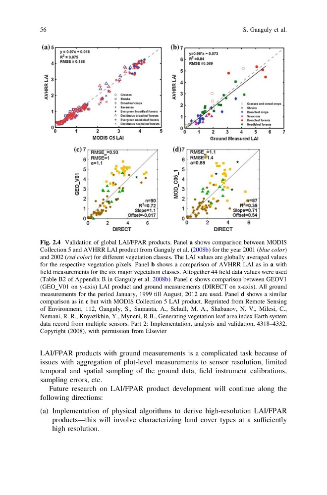
Fig. 2.4 Validation of global LAI/FPAR products. Panel a shows comparison between MODIS
Collection 5 and AVHRR LAI product from Ganguly et al. (2008b) for the year 2001 (blue color)
and 2002 (red color) for different vegetation classes. The LAI values are globally averaged values
for the respective vegetation pixels. Panel b shows a comparison of AVHRR LAI as in a with
field measurements for the six major vegetation classes. Altogether 44 field data values were used
(Table B2 of Appendix B in Ganguly et al. 2008b). Panel c shows comparison between GEOV1
(GEO_V01 on y-axis) LAI product and ground measurements (DIRECT on x-axis). All ground
measurements for the period January, 1999 till August, 2012 are used. Panel d shows a similar
comparison as in c but with MODIS Collection 5 LAI product. Reprinted from Remote Sensing
of Environment, 112, Ganguly, S., Samanta, A., Schull, M. A., Shabanov, N. V., Milesi, C.,
Nemani, R. R., Knyazikhin, Y., Myneni, R.B., Generating vegetation leaf area index Earth system
data record from multiple sensors. Part 2: Implementation, analysis and validation, 4318–4332,
Copyright (2008), with permission from Elsevier
56
S. Ganguly et al.
issues with aggregation of plot-level measurements to sensor resolution, limited
temporal and spatial sampling of the ground data, field instrument calibrations,
sampling errors, etc.
Future research on LAI/FPAR product development will continue along the
following directions:
(a) Implementation of physical algorithms to derive high-resolution LAI/FPAR
products—this will involve characterizing land cover types at a sufficiently
high resolution.
Fig. 2.4 Validation of global LAI/FPAR products. Panel a shows comparison between MODIS
Collection 5 and AVHRR LAI product from Ganguly et al. (2008b) for the year 2001 (blue color)
and 2002 (red color) for different vegetation classes. The LAI values are globally averaged values
for the respective vegetation pixels. Panel b shows a comparison of AVHRR LAI as in a with
field measurements for the six major vegetation classes. Altogether 44 field data values were used
(Table B2 of Appendix B in Ganguly et al. 2008b). Panel c shows comparison between GEOV1
(GEO_V01 on y-axis) LAI product and ground measurements (DIRECT on x-axis). All ground
measurements for the period January, 1999 till August, 2012 are used. Panel d shows a similar
comparison as in c but with MODIS Collection 5 LAI product. Reprinted from Remote Sensing
of Environment, 112, Ganguly, S., Samanta, A., Schull, M. A., Shabanov, N. V., Milesi, C.,
Nemani, R. R., Knyazikhin, Y., Myneni, R.B., Generating vegetation leaf area index Earth system
data record from multiple sensors. Part 2: Implementation, analysis and validation, 4318–4332,
Copyright (2008), with permission from Elsevier
56
S. Ganguly et al.