

A constrained view angle MVC (CV-MVC) has been adopted for use with
MODIS VI products (Huete et al. 2011). This method attempts to restrict pixel
selections to within ±30° by choosing the closest to nadir view pixel from a set of
2 or 3 highest NDVI values in the compositing period. Additionally, a per-pixel
QA-based methodology is used to filter out known problematic and noisy pixels
contaminated by residual clouds, shadow, high aerosol loadings, and large viewing
geometries. The CV-MVC method is then applied to the remaining higher quality
pixels. The selected VI value represents an actual observation (not modeled) for
the local solar zenith angle and close to nadir view geometry, and retain full
traceability to the sensor acquisition. Thus, they are not BRDF-corrected, but
rather minimized for BRDF influences. In a compositing study of MODIS and
AVHRR daily data for mapping burned area over the Iberian Peninsula, Chuvieco
et al. (2005) found this VI compositing procedure provided close to nadir observation angles and good spatial coherency, while the traditional MVC compositing
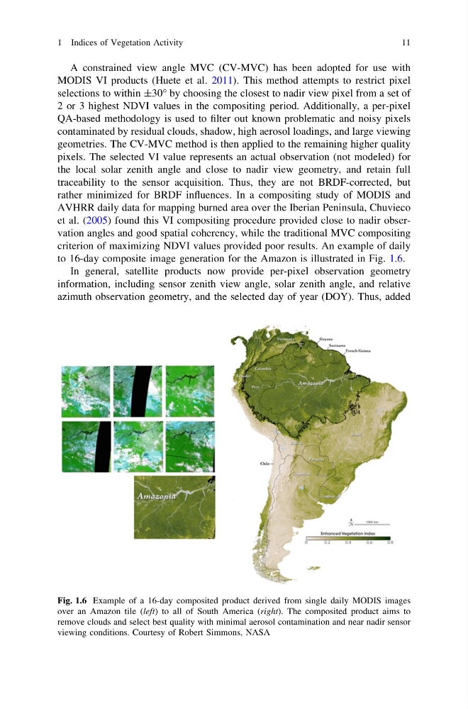
criterion of maximizing NDVI values provided poor results. An example of daily
to 16-day composite image generation for the Amazon is illustrated in Fig. 1.6.
In general, satellite products now provide per-pixel observation geometry
information, including sensor zenith view angle, solar zenith angle, and relative
azimuth observation geometry, and the selected day of year (DOY). Thus, added
Fig. 1.6 Example of a 16-day composited product derived from single daily MODIS images
over an Amazon tile (left) to all of South America (right). The composited product aims to
remove clouds and select best quality with minimal aerosol contamination and near nadir sensor
viewing conditions. Courtesy of Robert Simmons, NASA
1 Indices of Vegetation Activity
11
MODIS VI products (Huete et al. 2011). This method attempts to restrict pixel
selections to within ±30° by choosing the closest to nadir view pixel from a set of
2 or 3 highest NDVI values in the compositing period. Additionally, a per-pixel
QA-based methodology is used to filter out known problematic and noisy pixels
contaminated by residual clouds, shadow, high aerosol loadings, and large viewing
geometries. The CV-MVC method is then applied to the remaining higher quality
pixels. The selected VI value represents an actual observation (not modeled) for
the local solar zenith angle and close to nadir view geometry, and retain full
traceability to the sensor acquisition. Thus, they are not BRDF-corrected, but
rather minimized for BRDF influences. In a compositing study of MODIS and
AVHRR daily data for mapping burned area over the Iberian Peninsula, Chuvieco
et al. (2005) found this VI compositing procedure provided close to nadir observation angles and good spatial coherency, while the traditional MVC compositing
criterion of maximizing NDVI values provided poor results. An example of daily
to 16-day composite image generation for the Amazon is illustrated in Fig. 1.6.
In general, satellite products now provide per-pixel observation geometry
information, including sensor zenith view angle, solar zenith angle, and relative
azimuth observation geometry, and the selected day of year (DOY). Thus, added
Fig. 1.6 Example of a 16-day composited product derived from single daily MODIS images
over an Amazon tile (left) to all of South America (right). The composited product aims to
remove clouds and select best quality with minimal aerosol contamination and near nadir sensor
viewing conditions. Courtesy of Robert Simmons, NASA
1 Indices of Vegetation Activity
11