

1.3 Development of Satellite VI Products
A primary aim of a satellite VI product is to produce cloud-free, atmospherecorrected, and globally consistent VI values. A sequence of data processing steps
is generally made to achieve retrievals of higher quality satellite VI values. The atsatellite radiances are normalized by top-of-atmosphere solar irradiances to calculate ‘apparent reflectances’. The derived ‘apparent VI’ values will contain both
surface and atmosphere signals that confuse the interpretation of spatial and
temporal VI variations, since atmosphere scattering and absorption processes alter
the Red and NIR spectral contrasts of vegetated surfaces, thereby contaminating
the VI values. Atmosphere corrections are utilized to minimize this contamination
and produce top-of-canopy VI values that are more consistent with field-based and
tower-sensor VI measurements.
The VIs will remain particularly sensitive to any disproportionate atmospheric
correction of the Red and NIR bands. The inclusion of the Blue band in the EVI
was found to stabilize atmospheric aerosol effects in Northern Asia (Xiao et al.
2003) and in the Amazon during the biomass burning season (Miura et al. 2001).
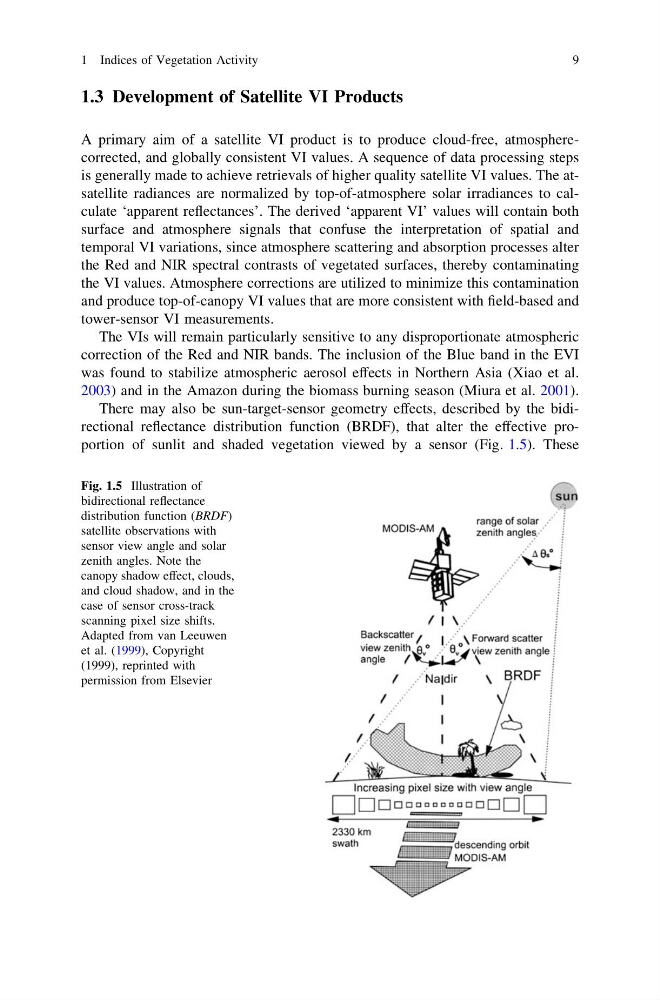
There may also be sun-target-sensor geometry effects, described by the bidirectional reflectance distribution function (BRDF), that alter the effective proportion of sunlit and shaded vegetation viewed by a sensor (Fig. 1.5). These
Fig. 1.5 Illustration of
bidirectional reflectance
distribution function (BRDF)
satellite observations with
sensor view angle and solar
zenith angles. Note the
canopy shadow effect, clouds,
and cloud shadow, and in the
case of sensor cross-track
scanning pixel size shifts.
Adapted from van Leeuwen
et al. (1999), Copyright
(1999), reprinted with
permission from Elsevier
1 Indices of Vegetation Activity
9
A primary aim of a satellite VI product is to produce cloud-free, atmospherecorrected, and globally consistent VI values. A sequence of data processing steps
is generally made to achieve retrievals of higher quality satellite VI values. The atsatellite radiances are normalized by top-of-atmosphere solar irradiances to calculate ‘apparent reflectances’. The derived ‘apparent VI’ values will contain both
surface and atmosphere signals that confuse the interpretation of spatial and
temporal VI variations, since atmosphere scattering and absorption processes alter
the Red and NIR spectral contrasts of vegetated surfaces, thereby contaminating
the VI values. Atmosphere corrections are utilized to minimize this contamination
and produce top-of-canopy VI values that are more consistent with field-based and
tower-sensor VI measurements.
The VIs will remain particularly sensitive to any disproportionate atmospheric
correction of the Red and NIR bands. The inclusion of the Blue band in the EVI
was found to stabilize atmospheric aerosol effects in Northern Asia (Xiao et al.
2003) and in the Amazon during the biomass burning season (Miura et al. 2001).
There may also be sun-target-sensor geometry effects, described by the bidirectional reflectance distribution function (BRDF), that alter the effective proportion of sunlit and shaded vegetation viewed by a sensor (Fig. 1.5). These
Fig. 1.5 Illustration of
bidirectional reflectance
distribution function (BRDF)
satellite observations with
sensor view angle and solar
zenith angles. Note the
canopy shadow effect, clouds,
and cloud shadow, and in the
case of sensor cross-track
scanning pixel size shifts.
Adapted from van Leeuwen
et al. (1999), Copyright
(1999), reprinted with
permission from Elsevier
1 Indices of Vegetation Activity
9