

NEE is the difference of two large carbon fluxes—photosynthesis (GPP) and
ecosystem respiration (R e ), and the errors of these two fluxes compensate each
other. For instance, underestimated GPP and underestimated R e may lead to an
accurate NEE estimate. A small error in GPP or R e can also translate to a large
error in NEE as the magnitude of GPP or R e is typically much larger than NEE. To
avoid compensating errors the basic processes underlying ecosystem carbon
uptake and release should both be modeled well (Richardson et al. 2007). Unlike
most modeling approaches, the data-driven approach directly estimates NEE,
which avoids the compensating errors.
6.3.2 MODIS Data
MODIS ASCII (American Standard Code for Information Interchange) subsets
(Collection 5) were obtained for each AmeriFlux site from the Oak Ridge National
Laboratory’s Distributed Active Archive Center (ORNL DAAC). These subsets
consist of 7 9 7 km regions centered on the flux tower, including surface
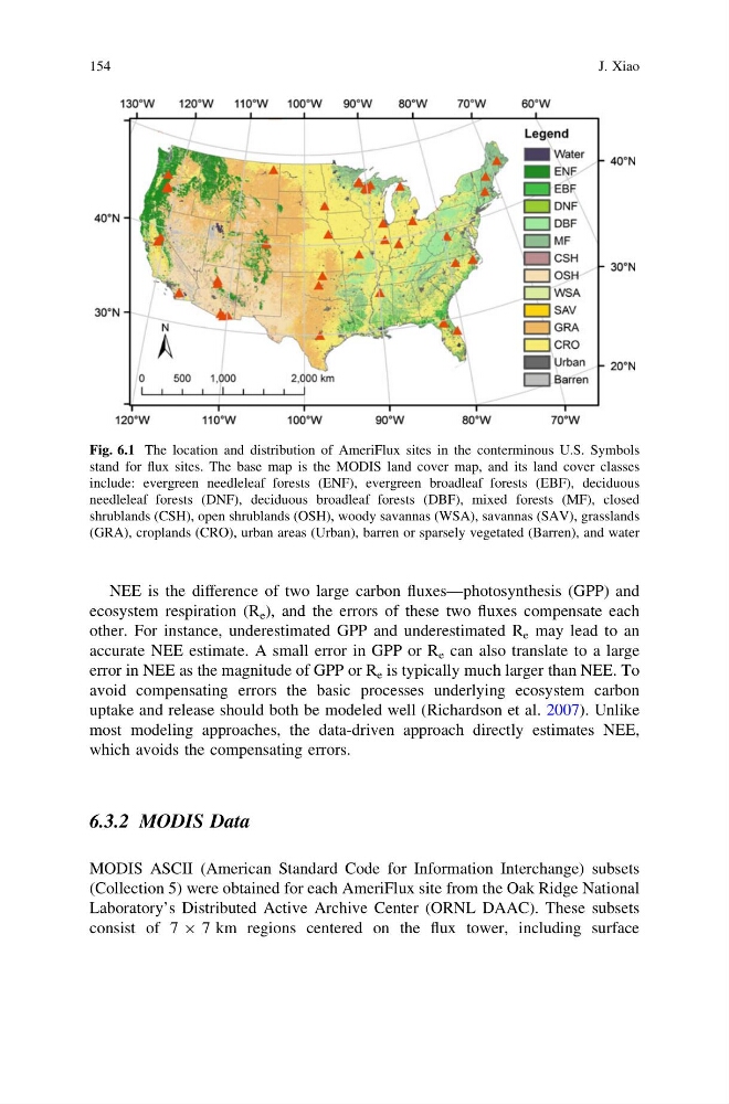
Fig. 6.1 The location and distribution of AmeriFlux sites in the conterminous U.S. Symbols
stand for flux sites. The base map is the MODIS land cover map, and its land cover classes
include: evergreen needleleaf forests (ENF), evergreen broadleaf forests (EBF), deciduous
needleleaf forests (DNF), deciduous broadleaf forests (DBF), mixed forests (MF), closed
shrublands (CSH), open shrublands (OSH), woody savannas (WSA), savannas (SAV), grasslands
(GRA), croplands (CRO), urban areas (Urban), barren or sparsely vegetated (Barren), and water
154
J. Xiao
ecosystem respiration (R e ), and the errors of these two fluxes compensate each
other. For instance, underestimated GPP and underestimated R e may lead to an
accurate NEE estimate. A small error in GPP or R e can also translate to a large
error in NEE as the magnitude of GPP or R e is typically much larger than NEE. To
avoid compensating errors the basic processes underlying ecosystem carbon
uptake and release should both be modeled well (Richardson et al. 2007). Unlike
most modeling approaches, the data-driven approach directly estimates NEE,
which avoids the compensating errors.
6.3.2 MODIS Data
MODIS ASCII (American Standard Code for Information Interchange) subsets
(Collection 5) were obtained for each AmeriFlux site from the Oak Ridge National
Laboratory’s Distributed Active Archive Center (ORNL DAAC). These subsets
consist of 7 9 7 km regions centered on the flux tower, including surface
Fig. 6.1 The location and distribution of AmeriFlux sites in the conterminous U.S. Symbols
stand for flux sites. The base map is the MODIS land cover map, and its land cover classes
include: evergreen needleleaf forests (ENF), evergreen broadleaf forests (EBF), deciduous
needleleaf forests (DNF), deciduous broadleaf forests (DBF), mixed forests (MF), closed
shrublands (CSH), open shrublands (OSH), woody savannas (WSA), savannas (SAV), grasslands
(GRA), croplands (CRO), urban areas (Urban), barren or sparsely vegetated (Barren), and water
154
J. Xiao