

3.4 Conclusions and Future Directions
Multispectral sensors are the only current remote sensing option that provides
information on mapping and monitoring of coral reefs at long time scales
([40 years) and large spatial scales (reef to global). Multispectral sensors that
contain the important blue band can map basic benthic features with reasonable
accuracy ([70 %), which can be improved by addition of texture information,
water column correction and contextual editing.
Multispectral satellite sensors are still evolving. Newer instruments offer higher
spatial resolution, higher spectral resolution, and greater data acquisition capacity.
For example, WorldView-2, which was launched on 8 October 2009, has 1.85-m
spatial resolution, 8 multispectral bands (coastal, blue, green, yellow, red, red
edge, and two near infrared bands; Table 3.1), and daily data acquisition capacity
of 950,000 km
2 . As sensors evolve, efforts will continue towards evaluating the
new sensors for different mapping applications (e.g., Mumby et al. 1997; Mumby
and Edwards 2002; Andréfouët et al. 2003; Yamano et al. 2006a), and analysis
techniques will also correspondingly progress and improve.
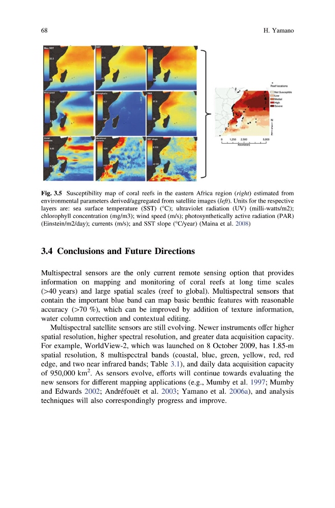
Fig. 3.5 Susceptibility map of coral reefs in the eastern Africa region (right) estimated from
environmental parameters derived/aggregated from satellite images (left). Units for the respective
layers are: sea surface temperature (SST) (°C); ultraviolet radiation (UV) (milli-watts/m2);
chlorophyll concentration (mg/m3); wind speed (m/s); photosynthetically active radiation (PAR)
(Einstein/m2/day); currents (m/s); and SST slope (°C/year) (Maina et al. 2008)
68
H. Yamano
Multispectral sensors are the only current remote sensing option that provides
information on mapping and monitoring of coral reefs at long time scales
([40 years) and large spatial scales (reef to global). Multispectral sensors that
contain the important blue band can map basic benthic features with reasonable
accuracy ([70 %), which can be improved by addition of texture information,
water column correction and contextual editing.
Multispectral satellite sensors are still evolving. Newer instruments offer higher
spatial resolution, higher spectral resolution, and greater data acquisition capacity.
For example, WorldView-2, which was launched on 8 October 2009, has 1.85-m
spatial resolution, 8 multispectral bands (coastal, blue, green, yellow, red, red
edge, and two near infrared bands; Table 3.1), and daily data acquisition capacity
of 950,000 km
2 . As sensors evolve, efforts will continue towards evaluating the
new sensors for different mapping applications (e.g., Mumby et al. 1997; Mumby
and Edwards 2002; Andréfouët et al. 2003; Yamano et al. 2006a), and analysis
techniques will also correspondingly progress and improve.
Fig. 3.5 Susceptibility map of coral reefs in the eastern Africa region (right) estimated from
environmental parameters derived/aggregated from satellite images (left). Units for the respective
layers are: sea surface temperature (SST) (°C); ultraviolet radiation (UV) (milli-watts/m2);
chlorophyll concentration (mg/m3); wind speed (m/s); photosynthetically active radiation (PAR)
(Einstein/m2/day); currents (m/s); and SST slope (°C/year) (Maina et al. 2008)
68
H. Yamano