

3.3.2 Change Detection
Because decadal-scale degradation of coral reefs has been primarily observed
using in situ data (Gardner et al. 2003), scaling up these observations to understand
the extent of reef decline at local, regional and global scales is an urgent task.
Analysis of aerial photography is one technique that has been used to detect
decadal changes of coral reefs back to the 1930s (Chap. 2). Photography provides
high spatial resolution and high thematic accuracy can be achieved, however the
acquisition interval is typically long ([5 years) and the ability to simultaneously
assess associated environmental change is limited. Multispectral satellite remote
sensing overcomes these issues, since reefs can be monitored at frequent intervals
(i.e., less than monthly if clouds do not obscure observation of target area) and the
same data can be used to investigate other environmental parameters (Table 3.2).
Level 1
Level 2
Level 3
Oceanic reefs
Atoll
Drowned atoll
Lagoon
Rim
Patch
Bank
Drowned bank
Bridge
Lagoon
Barrier
Patch
Uplifted atoll
Island
Land
Non reefal water bodies
Coastal barrier
Outer barrier
Multiple barrier
Barrier-fringing
Faro-barrier
Coastal/fringing patch
Intra-lagoon patch
Shelf patch
Ocean exposed fringing
Intra-seas exposed fringing
Lagoon exposed fringing
Shelf reefs
N
30 km
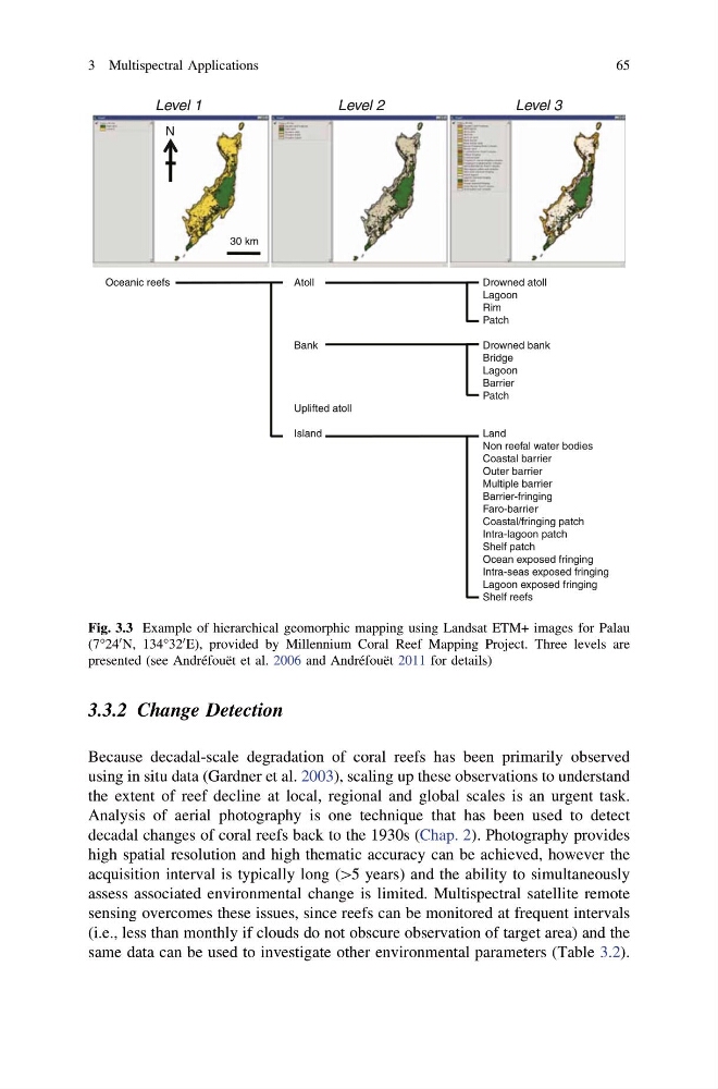
Fig. 3.3 Example of hierarchical geomorphic mapping using Landsat ETM+ images for Palau
(7°24
0 N, 134°32
0 E), provided by Millennium Coral Reef Mapping Project. Three levels are
presented (see Andréfouët et al. 2006 and Andréfouët 2011 for details)
3 Multispectral Applications
65
Because decadal-scale degradation of coral reefs has been primarily observed
using in situ data (Gardner et al. 2003), scaling up these observations to understand
the extent of reef decline at local, regional and global scales is an urgent task.
Analysis of aerial photography is one technique that has been used to detect
decadal changes of coral reefs back to the 1930s (Chap. 2). Photography provides
high spatial resolution and high thematic accuracy can be achieved, however the
acquisition interval is typically long ([5 years) and the ability to simultaneously
assess associated environmental change is limited. Multispectral satellite remote
sensing overcomes these issues, since reefs can be monitored at frequent intervals
(i.e., less than monthly if clouds do not obscure observation of target area) and the
same data can be used to investigate other environmental parameters (Table 3.2).
Level 1
Level 2
Level 3
Oceanic reefs
Atoll
Drowned atoll
Lagoon
Rim
Patch
Bank
Drowned bank
Bridge
Lagoon
Barrier
Patch
Uplifted atoll
Island
Land
Non reefal water bodies
Coastal barrier
Outer barrier
Multiple barrier
Barrier-fringing
Faro-barrier
Coastal/fringing patch
Intra-lagoon patch
Shelf patch
Ocean exposed fringing
Intra-seas exposed fringing
Lagoon exposed fringing
Shelf reefs
N
30 km
Fig. 3.3 Example of hierarchical geomorphic mapping using Landsat ETM+ images for Palau
(7°24
0 N, 134°32
0 E), provided by Millennium Coral Reef Mapping Project. Three levels are
presented (see Andréfouët et al. 2006 and Andréfouët 2011 for details)
3 Multispectral Applications
65