

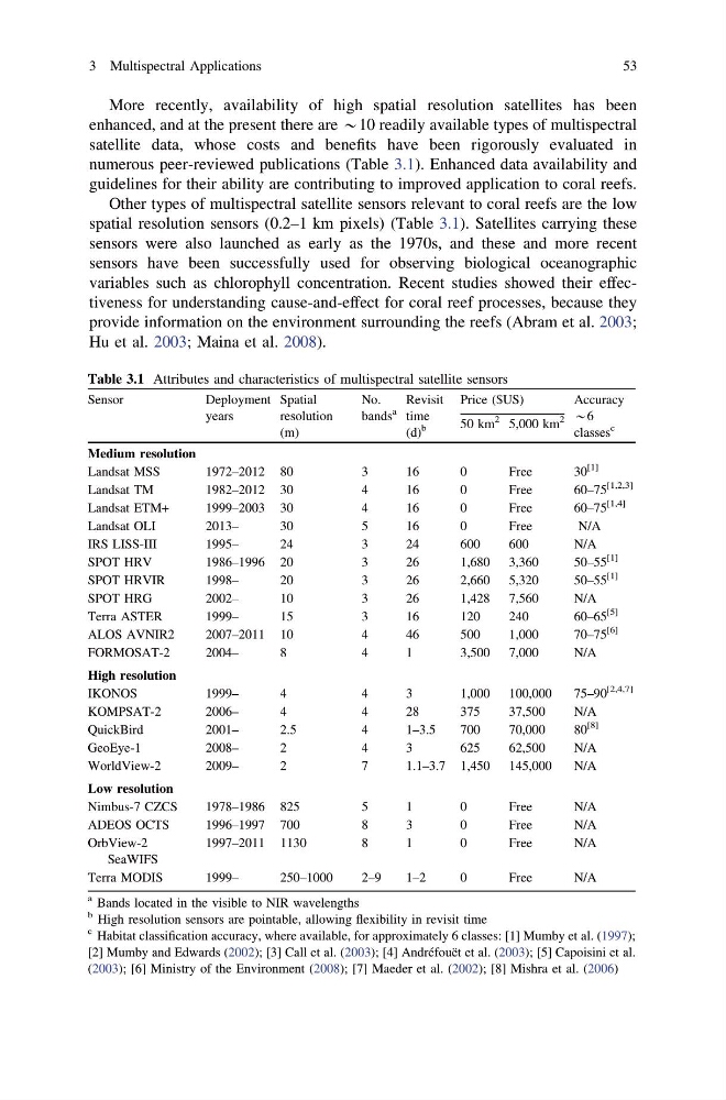
More recently, availability of high spatial resolution satellites has been
enhanced, and at the present there are *10 readily available types of multispectral
satellite data, whose costs and benefits have been rigorously evaluated in
numerous peer-reviewed publications (Table 3.1). Enhanced data availability and
guidelines for their ability are contributing to improved application to coral reefs.
Other types of multispectral satellite sensors relevant to coral reefs are the low
spatial resolution sensors (0.2–1 km pixels) (Table 3.1). Satellites carrying these
sensors were also launched as early as the 1970s, and these and more recent
sensors have been successfully used for observing biological oceanographic
variables such as chlorophyll concentration. Recent studies showed their effectiveness for understanding cause-and-effect for coral reef processes, because they
provide information on the environment surrounding the reefs (Abram et al. 2003;
Hu et al. 2003; Maina et al. 2008).
Table 3.1 Attributes and characteristics of multispectral satellite sensors
Sensor
Deployment
years
Spatial
resolution
(m)
No.
bands
a
Revisit
time
(d)
b
Price ($US)
Accuracy
*6
classes
c
50 km
2 5,000 km
2
Medium resolution
Landsat MSS
1972–2012 80
3
16
0
Free
30
[1]
Landsat TM
1982–2012 30
4
16
0
Free
60–75
[1,2,3]
Landsat ETM+
1999–2003 30
4
16
0
Free
60–75
[1,4]
Landsat OLI
2013–
30
5
16
0
Free
N/A
IRS LISS-III
1995–
24
3
24
600
600
N/A
SPOT HRV
1986–1996 20
3
26
1,680 3,360
50–55
[1]
SPOT HRVIR
1998–
20
3
26
2,660 5,320
50–55
[1]
SPOT HRG
2002–
10
3
26
1,428 7,560
N/A
Terra ASTER
1999–
15
3
16
120
240
60–65
[5]
ALOS AVNIR2
2007–2011 10
4
46
500
1,000
70–75
[6]
FORMOSAT-2
2004–
8
4
1
3,500 7,000
N/A
High resolution
IKONOS
1999–
4
4
3
1,000 100,000
75–90
[2,4,7]
KOMPSAT-2
2006–
4
4
28
375
37,500
N/A
QuickBird
2001–
2.5
4
1–3.5
700
70,000
80
[8]
GeoEye-1
2008–
2
4
3
625
62,500
N/A
WorldView-2
2009–
2
7
1.1–3.7 1,450 145,000
N/A
Low resolution
Nimbus-7 CZCS
1978–1986 825
5
1
0
Free
N/A
ADEOS OCTS
1996–1997 700
8
3
0
Free
N/A
OrbView-2
SeaWIFS
1997–2011 1130
8
1
0
Free
N/A
Terra MODIS
1999–
250–1000
2–9
1–2
0
Free
N/A
a Bands located in the visible to NIR wavelengths
b High resolution sensors are pointable, allowing flexibility in revisit time
c Habitat classification accuracy, where available, for approximately 6 classes: [1] Mumby et al. (1997);
[2] Mumby and Edwards (2002); [3] Call et al. (2003); [4] Andréfouët et al. (2003); [5] Capoisini et al.
(2003); [6] Ministry of the Environment (2008); [7] Maeder et al. (2002); [8] Mishra et al. (2006)
3 Multispectral Applications
53
enhanced, and at the present there are *10 readily available types of multispectral
satellite data, whose costs and benefits have been rigorously evaluated in
numerous peer-reviewed publications (Table 3.1). Enhanced data availability and
guidelines for their ability are contributing to improved application to coral reefs.
Other types of multispectral satellite sensors relevant to coral reefs are the low
spatial resolution sensors (0.2–1 km pixels) (Table 3.1). Satellites carrying these
sensors were also launched as early as the 1970s, and these and more recent
sensors have been successfully used for observing biological oceanographic
variables such as chlorophyll concentration. Recent studies showed their effectiveness for understanding cause-and-effect for coral reef processes, because they
provide information on the environment surrounding the reefs (Abram et al. 2003;
Hu et al. 2003; Maina et al. 2008).
Table 3.1 Attributes and characteristics of multispectral satellite sensors
Sensor
Deployment
years
Spatial
resolution
(m)
No.
bands
a
Revisit
time
(d)
b
Price ($US)
Accuracy
*6
classes
c
50 km
2 5,000 km
2
Medium resolution
Landsat MSS
1972–2012 80
3
16
0
Free
30
[1]
Landsat TM
1982–2012 30
4
16
0
Free
60–75
[1,2,3]
Landsat ETM+
1999–2003 30
4
16
0
Free
60–75
[1,4]
Landsat OLI
2013–
30
5
16
0
Free
N/A
IRS LISS-III
1995–
24
3
24
600
600
N/A
SPOT HRV
1986–1996 20
3
26
1,680 3,360
50–55
[1]
SPOT HRVIR
1998–
20
3
26
2,660 5,320
50–55
[1]
SPOT HRG
2002–
10
3
26
1,428 7,560
N/A
Terra ASTER
1999–
15
3
16
120
240
60–65
[5]
ALOS AVNIR2
2007–2011 10
4
46
500
1,000
70–75
[6]
FORMOSAT-2
2004–
8
4
1
3,500 7,000
N/A
High resolution
IKONOS
1999–
4
4
3
1,000 100,000
75–90
[2,4,7]
KOMPSAT-2
2006–
4
4
28
375
37,500
N/A
QuickBird
2001–
2.5
4
1–3.5
700
70,000
80
[8]
GeoEye-1
2008–
2
4
3
625
62,500
N/A
WorldView-2
2009–
2
7
1.1–3.7 1,450 145,000
N/A
Low resolution
Nimbus-7 CZCS
1978–1986 825
5
1
0
Free
N/A
ADEOS OCTS
1996–1997 700
8
3
0
Free
N/A
OrbView-2
SeaWIFS
1997–2011 1130
8
1
0
Free
N/A
Terra MODIS
1999–
250–1000
2–9
1–2
0
Free
N/A
a Bands located in the visible to NIR wavelengths
b High resolution sensors are pointable, allowing flexibility in revisit time
c Habitat classification accuracy, where available, for approximately 6 classes: [1] Mumby et al. (1997);
[2] Mumby and Edwards (2002); [3] Call et al. (2003); [4] Andréfouët et al. (2003); [5] Capoisini et al.
(2003); [6] Ministry of the Environment (2008); [7] Maeder et al. (2002); [8] Mishra et al. (2006)
3 Multispectral Applications
53