

required, and how the products are used to inform management decisions.
Section 15.3.1 discusses the use of baseline data and data products for compiling
reef inventories and prioritizing areas for protection on local to global scales, using
both scientific and local knowledge to inform mapping. Section 15.3.2 details
recent techniques developed to spatially predict reef fish assemblage characteristics across entire reefs and the uses of these tools for fisheries management.
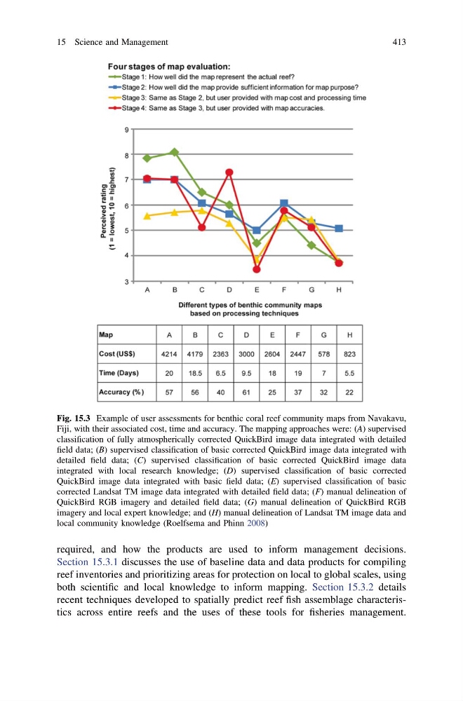
Fig. 15.3 Example of user assessments for benthic coral reef community maps from Navakavu,
Fiji, with their associated cost, time and accuracy. The mapping approaches were: (A) supervised
classification of fully atmospherically corrected QuickBird image data integrated with detailed
field data; (B) supervised classification of basic corrected QuickBird image data integrated with
detailed field data; (C) supervised classification of basic corrected QuickBird image data
integrated with local research knowledge; (D) supervised classification of basic corrected
QuickBird image data integrated with basic field data; (E) supervised classification of basic
corrected Landsat TM image data integrated with detailed field data; (F) manual delineation of
QuickBird RGB imagery and detailed field data; (G) manual delineation of QuickBird RGB
imagery and local expert knowledge; and (H) manual delineation of Landsat TM image data and
local community knowledge (Roelfsema and Phinn 2008)
15 Science and Management
413
Section 15.3.1 discusses the use of baseline data and data products for compiling
reef inventories and prioritizing areas for protection on local to global scales, using
both scientific and local knowledge to inform mapping. Section 15.3.2 details
recent techniques developed to spatially predict reef fish assemblage characteristics across entire reefs and the uses of these tools for fisheries management.
Fig. 15.3 Example of user assessments for benthic coral reef community maps from Navakavu,
Fiji, with their associated cost, time and accuracy. The mapping approaches were: (A) supervised
classification of fully atmospherically corrected QuickBird image data integrated with detailed
field data; (B) supervised classification of basic corrected QuickBird image data integrated with
detailed field data; (C) supervised classification of basic corrected QuickBird image data
integrated with local research knowledge; (D) supervised classification of basic corrected
QuickBird image data integrated with basic field data; (E) supervised classification of basic
corrected Landsat TM image data integrated with detailed field data; (F) manual delineation of
QuickBird RGB imagery and detailed field data; (G) manual delineation of QuickBird RGB
imagery and local expert knowledge; and (H) manual delineation of Landsat TM image data and
local community knowledge (Roelfsema and Phinn 2008)
15 Science and Management
413