

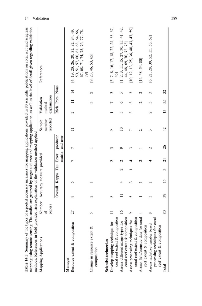
Table 14.5
Summary of the types of reported accuracy measures for mapping applications provided in 80 scientific publications on coral reef and seagrass
mapping using remote sensing. The studies are grouped by target audience and mapping application, as well as the level of detail given regarding validation
methods. References in bold provided rich explanation of the validation method applied
Mapping Applications
Number
of
papers
Accuracy measure provided
Sample
number
reported
Validation
method
explanation
References
Overall Kappa Tau Error
matrix
producer
and user
Rich Pore None
Manager
Resource extent & composition
27
9
5
7
7
11
2
11
14
[4, 19, 20, 26, 29, 31, 32, 34, 49,
50, 51, 57, 60, 61, 63, 64, 66,
67, 68, 71, 74, 75, 76, 77, 78,
79]
Change in resource extent &
composition
5
2
1
1
3
2
[9, 23, 46, 53, 65]
Scientist-technecian
Develop mapping technique for
coral reef extent & composition
11
8
2
3
9
1
7
3
[5, 7, 8, 16, 17, 18, 22, 24, 33, 37,
45]
Assess different image types for
coral reef extent & composition
16
11
4
2
2
9
10
5
6
5
[1, 2, 3, 11, 15, 27, 30, 35, 41, 42,
44, 48, 69, 70, 72, 73]
Assess processing techniques for
coral reef extent & composition
9
5
3
1
4
3
7
3
3
3
[10, 12, 13, 25, 36, 40, 43, 47, 59]
Assess field/acoustic data for coral
reef extent & composition
4
1
1
2
1
2
2
2
[14, 38, 54, 80]
Assess radiative transfer based
processing techniques for coral
reef extent & composition
8
3
1
4
2
3
2
3
3
[6, 21, 28, 39, 52, 55, 56, 62]
Total
80
39
15
3
21
26
42
13
35
32
14 Validation
389
Summary of the types of reported accuracy measures for mapping applications provided in 80 scientific publications on coral reef and seagrass
mapping using remote sensing. The studies are grouped by target audience and mapping application, as well as the level of detail given regarding validation
methods. References in bold provided rich explanation of the validation method applied
Mapping Applications
Number
of
papers
Accuracy measure provided
Sample
number
reported
Validation
method
explanation
References
Overall Kappa Tau Error
matrix
producer
and user
Rich Pore None
Manager
Resource extent & composition
27
9
5
7
7
11
2
11
14
[4, 19, 20, 26, 29, 31, 32, 34, 49,
50, 51, 57, 60, 61, 63, 64, 66,
67, 68, 71, 74, 75, 76, 77, 78,
79]
Change in resource extent &
composition
5
2
1
1
3
2
[9, 23, 46, 53, 65]
Scientist-technecian
Develop mapping technique for
coral reef extent & composition
11
8
2
3
9
1
7
3
[5, 7, 8, 16, 17, 18, 22, 24, 33, 37,
45]
Assess different image types for
coral reef extent & composition
16
11
4
2
2
9
10
5
6
5
[1, 2, 3, 11, 15, 27, 30, 35, 41, 42,
44, 48, 69, 70, 72, 73]
Assess processing techniques for
coral reef extent & composition
9
5
3
1
4
3
7
3
3
3
[10, 12, 13, 25, 36, 40, 43, 47, 59]
Assess field/acoustic data for coral
reef extent & composition
4
1
1
2
1
2
2
2
[14, 38, 54, 80]
Assess radiative transfer based
processing techniques for coral
reef extent & composition
8
3
1
4
2
3
2
3
3
[6, 21, 28, 39, 52, 55, 56, 62]
Total
80
39
15
3
21
26
42
13
35
32
14 Validation
389