

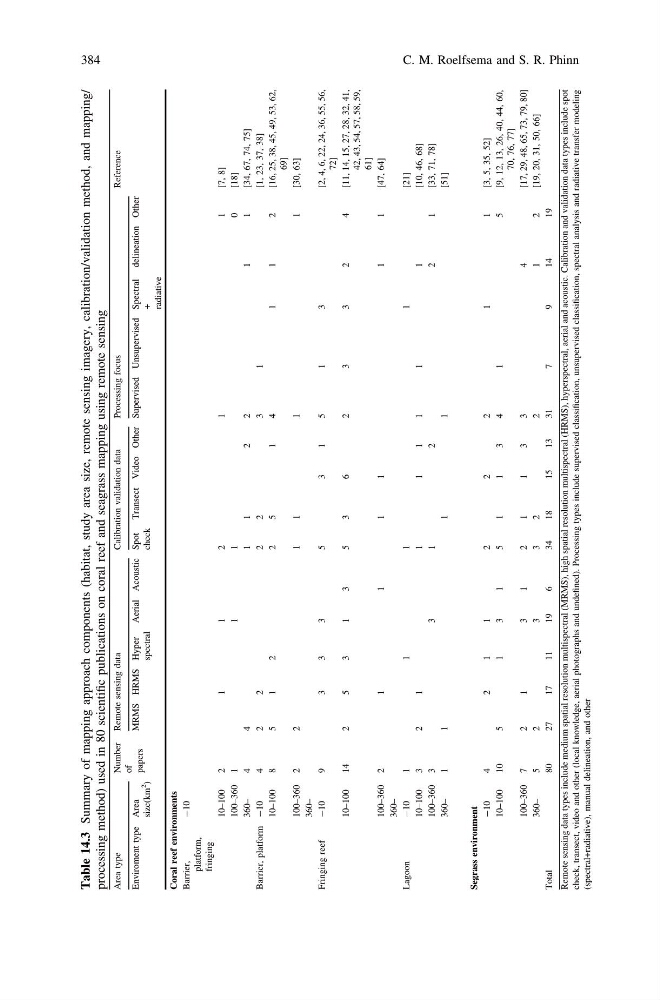
Table 14.3
Summary of mapping approach components (habitat, study area size, remote sensing imagery, calibration/validation method, and mapping/
processing method) used in 80 scientific publications on coral reef and seagrass mapping using remote sensing
Area type
Number
of
papers
Remote sensing data
Calibration validation data
Processing focus
Reference
Enviroment type Area
size(km
2
)
MRMS HRMS Hyper
spectral
Aerial Acoustic Spot
check
Transect Video Other Supervised Unsupervised Spectral
+
radiative
delineation Other
Coral reef environments
Barrier,
platform,
fringing
-10
10–100
2
1
1
2
1
1
[7, 8]
100–360 1
1
1
0
[18]
360–
4
4
1
1
2
2
1
1
[34, 67, 74, 75]
Barrier, platform -10
4
2
2
2
2
3
1
[1, 23, 37, 38]
10–100
8
5
1
2
2
5
1
4
1
1
2
[16, 25, 38, 45, 49, 53, 62,
69]
100–360 2
2
1
1
1
1
[30, 63]
360–
Fringing reef
-10
9
3
3
3
5
3
1
5
1
3
[2, 4, 6, 22, 24, 36, 55, 56,
72]
10–100
14
2
5
3
1
3
5
3
6
2
3
3
2
4
[11, 14, 15, 27, 28, 32, 41,
42, 43, 54, 57, 58, 59,
61]
100–360 2
1
1
1
1
1
1
[47, 64]
360–
Lagoon
-10
1
1
1
1
[21]
10–100
3
2
1
1
1
1
1
1
1
[10, 46, 68]
100–360 3
3
1
2
2
1
[33, 71, 78]
360–
1
1
1
1
[51]
Segrass environment
-10
4
2
1
1
2
2
2
1
1
[3, 5, 35, 52]
10–100
10
5
1
3
1
5
1
1
3
4
1
5
[9, 12, 13, 26, 40, 44, 60,
70, 76, 77]
100–360 7
2
1
3
1
2
1
1
3
3
4
[17, 29, 48, 65, 73, 79, 80]
360–
5
2
3
3
2
2
1
2
[19, 20, 31, 50, 66]
Total
80
27
17
11
19
6
34
18
15
13
31
7
9
14
19
Remote sensing data types include medium spatial resolution multispectral (MRMS), high spatial resolution multispectral (HRMS), hyperspectral, aerial and acoustic. Calibration and validation data types include spot
check, transect, video and other (local knowledge, aerial photographs and undefined). Processing types include supervised classification, unsupervised classification, spectral analysis and radiative transfer modeling
(spectral+radiative), manual delineation, and other
384
C. M. Roelfsema and S. R. Phinn
Summary of mapping approach components (habitat, study area size, remote sensing imagery, calibration/validation method, and mapping/
processing method) used in 80 scientific publications on coral reef and seagrass mapping using remote sensing
Area type
Number
of
papers
Remote sensing data
Calibration validation data
Processing focus
Reference
Enviroment type Area
size(km
2
)
MRMS HRMS Hyper
spectral
Aerial Acoustic Spot
check
Transect Video Other Supervised Unsupervised Spectral
+
radiative
delineation Other
Coral reef environments
Barrier,
platform,
fringing
-10
10–100
2
1
1
2
1
1
[7, 8]
100–360 1
1
1
0
[18]
360–
4
4
1
1
2
2
1
1
[34, 67, 74, 75]
Barrier, platform -10
4
2
2
2
2
3
1
[1, 23, 37, 38]
10–100
8
5
1
2
2
5
1
4
1
1
2
[16, 25, 38, 45, 49, 53, 62,
69]
100–360 2
2
1
1
1
1
[30, 63]
360–
Fringing reef
-10
9
3
3
3
5
3
1
5
1
3
[2, 4, 6, 22, 24, 36, 55, 56,
72]
10–100
14
2
5
3
1
3
5
3
6
2
3
3
2
4
[11, 14, 15, 27, 28, 32, 41,
42, 43, 54, 57, 58, 59,
61]
100–360 2
1
1
1
1
1
1
[47, 64]
360–
Lagoon
-10
1
1
1
1
[21]
10–100
3
2
1
1
1
1
1
1
1
[10, 46, 68]
100–360 3
3
1
2
2
1
[33, 71, 78]
360–
1
1
1
1
[51]
Segrass environment
-10
4
2
1
1
2
2
2
1
1
[3, 5, 35, 52]
10–100
10
5
1
3
1
5
1
1
3
4
1
5
[9, 12, 13, 26, 40, 44, 60,
70, 76, 77]
100–360 7
2
1
3
1
2
1
1
3
3
4
[17, 29, 48, 65, 73, 79, 80]
360–
5
2
3
3
2
2
1
2
[19, 20, 31, 50, 66]
Total
80
27
17
11
19
6
34
18
15
13
31
7
9
14
19
Remote sensing data types include medium spatial resolution multispectral (MRMS), high spatial resolution multispectral (HRMS), hyperspectral, aerial and acoustic. Calibration and validation data types include spot
check, transect, video and other (local knowledge, aerial photographs and undefined). Processing types include supervised classification, unsupervised classification, spectral analysis and radiative transfer modeling
(spectral+radiative), manual delineation, and other
384
C. M. Roelfsema and S. R. Phinn